East Midlands Regional Spatial Strategy 2005/06
East Midlands Regional Spatial Strategy 2005/06
East Midlands Regional Spatial Strategy 2005/06

Create successful ePaper yourself
Turn your PDF publications into a flip-book with our unique Google optimized e-Paper software.
5.28 Thus only partial information on this indicator<br />
has been found and this is the first time these<br />
comprehensive figures have been fully available.<br />
Data Analysis<br />
5.29 Although partial data has been found on the<br />
overall increase in woodland in the <strong>East</strong> <strong>Midlands</strong>, a<br />
significant development is undoubtedly the increase<br />
in woodlands that form part of the National Forest.<br />
The National Forest covers 200 square miles of<br />
Leicestershire, Derbyshire and Staffordshire. Initially<br />
6% of the land in the area had been woodland. This<br />
has now increased to around 16% with the planting<br />
of over 6 million trees (www.nationalforest.org).<br />
Policy Commentary<br />
Results:<br />
Significant Effects Indicator<br />
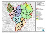
Figure 5.4 - Landscape Character<br />
Assessments in the <strong>East</strong> <strong>Midlands</strong> 20<strong>06</strong><br />
5.30 Over the last decade the rate of woodland<br />
creation supported through grant has been between<br />
500 and 850 hectares per annum.The figure for this<br />
year is significant but falls well short of the rate<br />
required to meet the target set out in the RSS of<br />
65,000 ha by 2021.<br />
5.31 <strong>2005</strong> year saw the publication of the <strong>Regional</strong><br />
Forestry Framework for the <strong>East</strong> <strong>Midlands</strong>;<br />
‘Space4trees’. This important publication seeks to<br />
integrate forestry with wider socio, economic and<br />
environmental objectives. It will guide the future<br />
work of the Forestry Commission and its partners in<br />
the region.<br />
Policy 30: Priorities for the Management and<br />
Enhancement of the Region’s Landscape<br />
Development Plans, LDFs and other Strategies<br />
should:<br />
• Continue to promote the highest level of<br />
landscape character protection<br />
• Promote initiatives to protect and enhance the<br />
natural and heritage landscape assets<br />
• Be informed by Landscape Character Assessments<br />
Target:<br />
• % of region covered by Landscape Character<br />
Assessments - 100% of rural areas<br />
Indicator:<br />
• % of region covered by Landscape Character<br />
Assessments<br />
Source: Natural England<br />
© Crown Copyright. All rights reserved.<br />
<strong>East</strong> <strong>Midlands</strong> <strong>Regional</strong> Assembly, 100038615, 20<strong>06</strong><br />
Data Analysis<br />
5.32 The information for this policy area has been<br />
provided by Natural England who undertook a<br />
survey in February/March 20<strong>06</strong>.This showed that 17<br />
local authorities had a Landscape Character<br />
Assessment (LCA) in place and that other local<br />
authorities were at different stages of development,<br />
with a number of studies underway. The Natural<br />
England view is that Derbyshire Dales is partially<br />
covered by a LCA, Leicestershire has a Landscape and<br />
Woodland <strong>Strategy</strong> which does not give sufficient<br />
LCA coverage to Districts, although some Districts<br />
have done their own LCAs . Northamptonshire were<br />
due to launch their LCA in November 20<strong>06</strong>;<br />
Harborough and Hinckley & Bosworth were due to<br />
have their LCAs completed in November 20<strong>06</strong>.<br />
Information on Landscape Character Assessments<br />
was also gathered via the monitoring questionnaires<br />
sent to local authorities, which largely confirmed the<br />
information from Natural England.<br />
<strong>East</strong> <strong>Midlands</strong> <strong>Regional</strong> <strong>Spatial</strong> <strong>Strategy</strong> Annual Monitoring Report <strong>2005</strong>/<strong>06</strong><br />
83