East Midlands Regional Spatial Strategy 2005/06
East Midlands Regional Spatial Strategy 2005/06
East Midlands Regional Spatial Strategy 2005/06

You also want an ePaper? Increase the reach of your titles
YUMPU automatically turns print PDFs into web optimized ePapers that Google loves.
<strong>East</strong> <strong>Midlands</strong> <strong>Regional</strong> <strong>Spatial</strong> <strong>Strategy</strong> Annual Monitoring Report <strong>2005</strong>/<strong>06</strong><br />
Policy 36: A <strong>Regional</strong> Approach to Managing<br />
Flood Risk<br />
Development plans and strategies of relevant<br />
agencies should include policies to prevent<br />
inappropriate development where there would<br />
be an adverse impact on the coastal and fluvial<br />
floodplain areas; deliver a programme of flood<br />
management schemes and require sustainable<br />
drainage<br />
Targets:<br />
• To be developed<br />
Indicators:<br />
• Planning permissions granted contrary to<br />
Environment Agency advice on flood defence<br />
grounds<br />
• Planning permissions granted with Sustainable<br />
Drainage Schemes (SuDS)<br />
• Number of properties at 1% flood risk<br />
• Number of strategic flood risk assessments<br />
undertaken<br />
Results:<br />
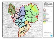
Figure 5.9 - Flood risk in the <strong>East</strong> <strong>Midlands</strong><br />
Flood Risk<br />
5.60 The total number of planning<br />
permissions granted contrary to<br />
Environment Agency advice on flood risk<br />
grounds was 20 in 2004/05. In 2003/04 it<br />
was 133.This represents a significant fall.<br />
This is mainly due to the publication of<br />
draft planning advice by the Government<br />
which recognises the risks and promotes<br />
a sequential approach to selection of<br />
land for development.The new Planning<br />
Policy Statement (PPS 25) was published<br />
at the end of December 20<strong>06</strong>.<br />
5.61 The number of properties in a 1%<br />
flood risk area is approximately 173,000<br />
in <strong>East</strong> <strong>Midlands</strong>. 1% flood risk means<br />
that there is a risk of flooding and that<br />
these properties are in the floodplain.The<br />
<strong>East</strong> <strong>Midlands</strong> has nearly as many<br />
properties in areas with a moderate or<br />
significant chance of flooding - almost<br />
154,000 - as the South <strong>East</strong> of England.<br />
The <strong>East</strong> <strong>Midlands</strong> has almost twice the<br />
proportion of land at significant chance<br />
of flooding than the next highest region<br />
(<strong>East</strong> of England). It also has the highest<br />
proportion of land (16%) at a moderate<br />
or significant risk of flooding.This is the<br />
first year that this data on the number of<br />
properties affected has been made<br />
available and the figure is approximate.<br />
92