- Page 1: Maphumulo Local MunicipalityMaphumu
- Page 5 and 6: 4.2.2.2 The New Growth Path Focus .
- Page 7 and 8: 6.6.4 THE PLAN ....................
- Page 9 and 10: Figure 9: Infrastructure, Community
- Page 11 and 12: FOREWORD BY HER WORSHIP, THE MAYOR
- Page 13 and 14: 1. Municipal Transformation and Ins
- Page 15 and 16: the local economy and the search fo
- Page 17 and 18: 1.7 MUNICIPAL TURN AROUND STRATEGY
- Page 19 and 20: infrastructure limits social inclus
- Page 21: 2.2 PROFILE OF THE MAPHUMULO MUNICI
- Page 24 and 25: 2.2.2.3 Sectoral ContributionPublic
- Page 26 and 27: 2.2.2.6 Poverty Stricken AreasThe e
- Page 28 and 29: Mandeni does not have a hospital th
- Page 30 and 31: CrimeCategoryApril2003-March2004Apr
- Page 32 and 33: 2.2.7 DISASTER MANAGEMENTILembe Dis
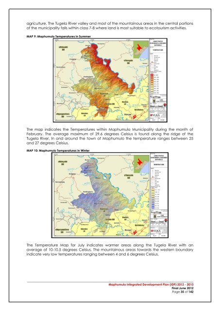
- Page 34 and 35: MAP 5: Maphumulo GeologyGneiss foun
- Page 38 and 39: MAP 13: Maphumulo Land SensitivityT
- Page 40 and 41: The Slope of Maphumulo indicates th
- Page 42 and 43: 17. The Department of Environmental
- Page 44 and 45: Eco-School ProgrammeWithin IDM, DAE
- Page 46 and 47: 11 1,812 1,812 59 1,753 59 97%Total
- Page 48 and 49: Funding for stage2 approved.KwaHlon
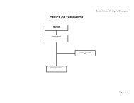
- Page 50 and 51: 2.6.3 ORGANISATIONAL STRUCTUREThe r
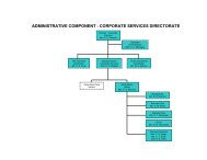
- Page 52 and 53: Figure 10: Budget and Treasury Depa
- Page 54 and 55: 2.6.6 COMMUNITY DEVELOPMENT WORKER
- Page 56 and 57: strategic session include; the purp
- Page 58 and 59: HousingEconomicDevelopmentandWater
- Page 60 and 61: OPPORTUNITIESOpportunity to effecti
- Page 62 and 63: Energy Usage- environmental changeA
- Page 64 and 65: 3.1.4 MAPHUMULO VISIONThe municipal
- Page 66 and 67: 4 CHAPTER 4 - THE SPATIAL DEVELOPME
- Page 68 and 69: 4.2.2 THE NEW GROWTH PATH4.2.2.1 In
- Page 70 and 71: 4.2.3 PROVINCIAL SPATIAL ECONOMIC D
- Page 72 and 73: 4.2.4 THE PROVINCIAL GROWTH AND DEV
- Page 74 and 75: Capitalise on complementarities and
- Page 76 and 77: The various nodes and their broad i
- Page 78 and 79: MAP 18: Provincial Spatial Developm
- Page 80 and 81: MaphumuloMunicipalityMAP 20: KZN Sp
- Page 82 and 83: inputs and thus the investment requ
- Page 84 and 85: Settlement in Maphumulo Municipalit
- Page 86 and 87:
Introduction and application of the
- Page 88 and 89:
4.11.1 PRIMARY CORRIDORSThe primary
- Page 90 and 91:
They are to be used to manage, dire
- Page 92 and 93:
Protection and enhancement of the n
- Page 94 and 95:
7.3 DEPARTMENT OF EDUCATIONThe visi
- Page 96 and 97:
7.5 DEPARTMENT OF COPERATIVR GOVERN
- Page 98 and 99:
7.8 THE DEPARTMENT SOCIAL DEVELOPME
- Page 100 and 101:
7.11 DEPARTMENT SPORT &RECREATION7.
- Page 102 and 103:
MaphumuloOtimati old clinicconversi
- Page 104 and 105:
Joel Jp 3 Constructi 10,277,520onKw
- Page 106 and 107:
Cemeteries:StudyDevelopmentPlannedS
- Page 108 and 109:
development, infrastructure and inc
- Page 110 and 111:
6.2.5 THE PLANThe plan aims to ensu
- Page 112 and 113:
Refer to KPA Schedule and Performan
- Page 114 and 115:
• Task 1: Development of a transp
- Page 116 and 117:
* The figures are subject to change
- Page 118 and 119:
6.6 FINANCIAL VIABILITY AND MANAGEM
- Page 120 and 121:
7 CHAPTER 7 - FINANCIAL MANAGEMENT7
- Page 122 and 123:
Below is a summary of expenditure a
- Page 124 and 125:
Figure 20: Maphumulo Capital Budget
- Page 126 and 127:
Ensuring that growth in services is
- Page 128 and 129:
8.4 MAPHUMULO PERFORMANCE MANAGEMEN
- Page 130 and 131:
Figure 23: IDP / Budget / PMS LinkI
- Page 132 and 133:
9 CHAPTER 9 - IMPLEMENTATION PLAN9.
- Page 134 and 135:
Continued and effective participati
- Page 136 and 137:
The results of policy decisions bec
- Page 138 and 139:
Annexure A:Spatial Development Fram
- Page 140 and 141:
12 APPENDICES______________________
- Page 143 and 144:
Maphumulo Local MunicipalityCapital
- Page 145 and 146:
Maphumulo Local MunicipalityCapital
- Page 147 and 148:
Maphumulo Local MunicipalityCapital
- Page 149:
Appendix 2:Service Delivery Budget