Introduction and application of the Land Use Scheme based on the Land UseManagement System as adopted by the Municipality or the LUMS guidelines asdeveloped by the Provincial Government.4.10.2 SECONDARY NODESIn view of the fact that <strong>Maphumulo</strong> Municipality is generally rural in nature, the secondarynodes are small, low-key and emerging centres located either at the intersection of majorarterial routes or along these routes. They may include a few community services, low ordercommercial facilities and serve as meeting places. Strategies for dealing with these areasshould include the following: Engaging the local stakeholders (Traditional Authorities, Community Basedorganizations, etc.) in defining the size and geographic extent (boundaries) of theseareas. Formulation of development frameworks for each node taking into account itscharacter, existing land use/activities, development potential and latent opportunities. Introduction and application of the Land Use Scheme based on the Land UseManagement System as adopted by the Municipality or the LUMS guidelines asdeveloped by the Provincial Government.4.10.3 TERTIARY NODESTertiary nodes are incipient in nature and serve as periodic service centres (pension paypoints,mobile clinics, etc.), but may also include services such as an informal taxi rank, localconvenient shops such as spaza shops, informal traders and a community hall. Strategies forthe development of these areas should focus on the formulation of broad strategicguidelines for managing future allocation of land rights, resources and location of projects. Itis also important to assess the status quo of service delivery in terms of sewerage, water andenergy provision. This will assist in providing required services and/or infrastructure such on-sitewater provision, street lighting, sewerage disposal, tarred roads, street/pavement paving,etc.Areas such as the KwaShushu hotsprings, Itshe lika Ntunjambili (the Kop) are identified as lowkey tourism areas within the Municipality. Small scale tourism development around theseareas should be encouraged to add to the uniqueness and tourism attractiveness of thearea. There is a demand for middle income housing and rental stock in the municipality andthe area identified on this SDF which can possibly accommodate this kind of development isthe Primary Node, <strong>Maphumulo</strong> Town and possibly Ntunjambili. Other areas identified forfuture housing within the municipal area are AmaNgcolosi, AmaMbedu, AmaBomvini,Nodunga and Hlongwa areas. In semi-rural/rural Communities developments should be ruralbased,of a small scale, labour orientated and related to the existing agricultural activitiesand the natural resource base. It is envisaged that subsistence agriculture and housing willbe the primary land use in this zone, exceeding tourism in importance. Particular attentionshould be paid to the retention of the integrity of rural landscapes.Low key commercial activities are to be promoted at <strong>Maphumulo</strong> Town area. These shouldinclude office development and mixed use development. Light industrial activities are to bepromoted at the Ntunjambili Node due to accessibility to transport routes which are not asbusy as other corridors and possibly have minimal environmental impacts. At all thesepotential designations, it is important that Local Area <strong>Development</strong> Plans be undertaken withthe <strong>Maphumulo</strong> Town and Ntunjambili Nodes being priority. The <strong>Maphumulo</strong> Spatial<strong>Development</strong> Framework Map is attached hereto as Annexure A.__________________________________________________________________________________________<strong>Maphumulo</strong> Integrated <strong>Development</strong> Plan (<strong>IDP</strong>) 2012 - 2013Final June 2012Page 85 of 142
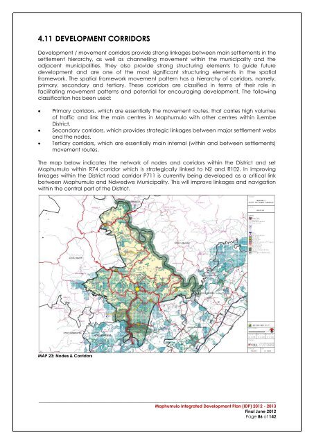
4.11 DEVELOPMENT CORRIDORS<strong>Development</strong> / movement corridors provide strong linkages between main settlements in thesettlement hierarchy, as well as channelling movement within the municipality and theadjacent municipalities. They also provide strong structuring elements to guide futuredevelopment and are one of the most significant structuring elements in the spatialframework. The spatial framework movement pattern has a hierarchy of corridors, namely,primary, secondary and tertiary. These corridors are classified in terms of their role infacilitating movement patterns and potential for encouraging development. The followingclassification has been used:Primary corridors, which are essentially the movement routes, that carries high volumesof traffic and link the main centres in <strong>Maphumulo</strong> with other centres within iLembeDistrict.Secondary corridors, which provides strategic linkages between major settlement websand the nodes.Tertiary corridors, which are essentially main internal (within and between settlements)movement routes.The map below indicates the network of nodes and corridors within the District and set<strong>Maphumulo</strong> within R74 corridor which is strategically linked to N2 and R102. In improvinglinkages within the District road corridor P711 is currently being developed as a critical linkbetween <strong>Maphumulo</strong> and Ndwedwe Municipality. This will improve linkages and navigationwithin the central part of the District.MAP 23: Nodes & Corridors__________________________________________________________________________________________<strong>Maphumulo</strong> Integrated <strong>Development</strong> Plan (<strong>IDP</strong>) 2012 - 2013Final June 2012Page 86 of 142
- Page 1:
Maphumulo Local MunicipalityMaphumu
- Page 5 and 6:
4.2.2.2 The New Growth Path Focus .
- Page 7 and 8:
6.6.4 THE PLAN ....................
- Page 9 and 10:
Figure 9: Infrastructure, Community
- Page 11 and 12:
FOREWORD BY HER WORSHIP, THE MAYOR
- Page 13 and 14:
1. Municipal Transformation and Ins
- Page 15 and 16:
the local economy and the search fo
- Page 17 and 18:
1.7 MUNICIPAL TURN AROUND STRATEGY
- Page 19 and 20:
infrastructure limits social inclus
- Page 21:
2.2 PROFILE OF THE MAPHUMULO MUNICI
- Page 24 and 25:
2.2.2.3 Sectoral ContributionPublic
- Page 26 and 27:
2.2.2.6 Poverty Stricken AreasThe e
- Page 28 and 29:
Mandeni does not have a hospital th
- Page 30 and 31:
CrimeCategoryApril2003-March2004Apr
- Page 32 and 33:
2.2.7 DISASTER MANAGEMENTILembe Dis
- Page 34 and 35:
MAP 5: Maphumulo GeologyGneiss foun
- Page 36 and 37: agriculture. The Tugela River valle
- Page 38 and 39: MAP 13: Maphumulo Land SensitivityT
- Page 40 and 41: The Slope of Maphumulo indicates th
- Page 42 and 43: 17. The Department of Environmental
- Page 44 and 45: Eco-School ProgrammeWithin IDM, DAE
- Page 46 and 47: 11 1,812 1,812 59 1,753 59 97%Total
- Page 48 and 49: Funding for stage2 approved.KwaHlon
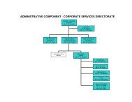
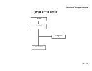
- Page 50 and 51: 2.6.3 ORGANISATIONAL STRUCTUREThe r
- Page 52 and 53: Figure 10: Budget and Treasury Depa
- Page 54 and 55: 2.6.6 COMMUNITY DEVELOPMENT WORKER
- Page 56 and 57: strategic session include; the purp
- Page 58 and 59: HousingEconomicDevelopmentandWater
- Page 60 and 61: OPPORTUNITIESOpportunity to effecti
- Page 62 and 63: Energy Usage- environmental changeA
- Page 64 and 65: 3.1.4 MAPHUMULO VISIONThe municipal
- Page 66 and 67: 4 CHAPTER 4 - THE SPATIAL DEVELOPME
- Page 68 and 69: 4.2.2 THE NEW GROWTH PATH4.2.2.1 In
- Page 70 and 71: 4.2.3 PROVINCIAL SPATIAL ECONOMIC D
- Page 72 and 73: 4.2.4 THE PROVINCIAL GROWTH AND DEV
- Page 74 and 75: Capitalise on complementarities and
- Page 76 and 77: The various nodes and their broad i
- Page 78 and 79: MAP 18: Provincial Spatial Developm
- Page 80 and 81: MaphumuloMunicipalityMAP 20: KZN Sp
- Page 82 and 83: inputs and thus the investment requ
- Page 84 and 85: Settlement in Maphumulo Municipalit
- Page 88 and 89: 4.11.1 PRIMARY CORRIDORSThe primary
- Page 90 and 91: They are to be used to manage, dire
- Page 92 and 93: Protection and enhancement of the n
- Page 94 and 95: 7.3 DEPARTMENT OF EDUCATIONThe visi
- Page 96 and 97: 7.5 DEPARTMENT OF COPERATIVR GOVERN
- Page 98 and 99: 7.8 THE DEPARTMENT SOCIAL DEVELOPME
- Page 100 and 101: 7.11 DEPARTMENT SPORT &RECREATION7.
- Page 102 and 103: MaphumuloOtimati old clinicconversi
- Page 104 and 105: Joel Jp 3 Constructi 10,277,520onKw
- Page 106 and 107: Cemeteries:StudyDevelopmentPlannedS
- Page 108 and 109: development, infrastructure and inc
- Page 110 and 111: 6.2.5 THE PLANThe plan aims to ensu
- Page 112 and 113: Refer to KPA Schedule and Performan
- Page 114 and 115: • Task 1: Development of a transp
- Page 116 and 117: * The figures are subject to change
- Page 118 and 119: 6.6 FINANCIAL VIABILITY AND MANAGEM
- Page 120 and 121: 7 CHAPTER 7 - FINANCIAL MANAGEMENT7
- Page 122 and 123: Below is a summary of expenditure a
- Page 124 and 125: Figure 20: Maphumulo Capital Budget
- Page 126 and 127: Ensuring that growth in services is
- Page 128 and 129: 8.4 MAPHUMULO PERFORMANCE MANAGEMEN
- Page 130 and 131: Figure 23: IDP / Budget / PMS LinkI
- Page 132 and 133: 9 CHAPTER 9 - IMPLEMENTATION PLAN9.
- Page 134 and 135: Continued and effective participati
- Page 136 and 137:
The results of policy decisions bec
- Page 138 and 139:
Annexure A:Spatial Development Fram
- Page 140 and 141:
12 APPENDICES______________________
- Page 143 and 144:
Maphumulo Local MunicipalityCapital
- Page 145 and 146:
Maphumulo Local MunicipalityCapital
- Page 147 and 148:
Maphumulo Local MunicipalityCapital
- Page 149:
Appendix 2:Service Delivery Budget