Maphumulo IDP - KZN Development Planning
Maphumulo IDP - KZN Development Planning
Maphumulo IDP - KZN Development Planning

You also want an ePaper? Increase the reach of your titles
YUMPU automatically turns print PDFs into web optimized ePapers that Google loves.
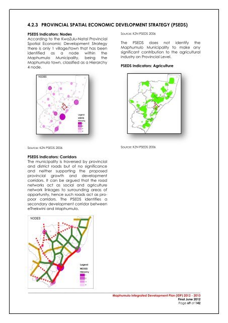
4.2.3 PROVINCIAL SPATIAL ECONOMIC DEVELOPMENT STRATEGY (PSEDS)PSEDS Indicators: NodesAccording to the KwaZulu-Natal ProvincialSpatial Economic <strong>Development</strong> Strategythere is only 1 village/town that has beenidentified as a node within the<strong>Maphumulo</strong> Municipality, being the<strong>Maphumulo</strong> town, classified as a Hierarchy4 node.Source: <strong>KZN</strong> PSEDS 2006The PSEDS does not identify the<strong>Maphumulo</strong> Municipality to make anysignificant contribution to the agriculturalindustry on Provincial Level.PSEDS Indicators: AgricultureSource: <strong>KZN</strong> PSEDS 2006Source: <strong>KZN</strong> PSEDS 2006PSEDS Indicators: CorridorsThe municipality is traversed by provincialand district roads but of no significanceand neither supporting the proposedprovincial growth and developmentcorridors. It can be argued that the roadnetworks act as social and agriculturenetwork linkages to surrounding areas ofopportunity, hence such roads act as propoorcorridors. The PSEDS identifies asecondary development corridor betweeneThekwini and <strong>Maphumulo</strong>.__________________________________________________________________________________________<strong>Maphumulo</strong> Integrated <strong>Development</strong> Plan (<strong>IDP</strong>) 2012 - 2013Final June 2012Page 69 of 142