- Page 2 and 3:
The International Rice Research Ins
- Page 4 and 5:
Monitoring rainfed and irrigated ri
- Page 6 and 7:
ForewordRainfed rice areas are asso
- Page 8 and 9:
AcknowledgmentsIRRI is most gratefu
- Page 10 and 11:
2 Singh et al
- Page 12 and 13:
development, for example, provision
- Page 14 and 15:
subecosystems were recognized withi
- Page 16 and 17:
Table 3. Methods commonly used in e
- Page 18 and 19:
Table 4 continued.Scale of analysis
- Page 20 and 21:
Table 4 continued.Scale of analysis
- Page 22 and 23:
This included standard countrywide
- Page 24 and 25:
deepwater rice ecosystems. The rese
- Page 26 and 27:
Table 5 continued.Main MethodologyC
- Page 28 and 29:
Table 5 continued.Main MethodologyC
- Page 30 and 31:
Table 5 continued.Main Scale presen
- Page 32 and 33:
levels of involvement. For example,
- Page 34 and 35:
●●●ecosystem classifications
- Page 36 and 37:
Conclusionsclearly that they are di
- Page 38 and 39:
IRRI (International Rice Research I
- Page 40 and 41:
Widawsky DA, O’Toole JC. 1990. Pr
- Page 42 and 43:
Rice is the staple food crop for mo
- Page 44 and 45:
first working group to identify the
- Page 46 and 47:
TropicsSubtropicsTemperateSummer/wi
- Page 48 and 49:
ferred it for wide adoption by farm
- Page 50 and 51:
ing, remote sensing, and computing
- Page 52 and 53:
ice environments will be needed to
- Page 54 and 55:
Insects and diseasesInsects and dis
- Page 56 and 57:
The completeness of characterizatio
- Page 58 and 59:
Table 7. Levels and scales for agro
- Page 60 and 61:
Jamin JY, Andriesse W. 1993. Discus
- Page 62 and 63:
Tools and methodologiesfor biophysi
- Page 64 and 65:
Effect of climate, agrohydrology,an
- Page 66 and 67:
to water deficit because the crop
- Page 68 and 69:
for different periods of the year:
- Page 70 and 71:
depth scenarios (shallow, medium, a
- Page 72 and 73:
Water table depth (cm)500Shallow wa
- Page 74 and 75:
Simulated yield (kg ha -1 )6,0005,0
- Page 76 and 77:
Perception, understanding,and mappi
- Page 78 and 79:
and rice yield at regional or more
- Page 80 and 81:
SubareaSampling sites:GridTransectR
- Page 82 and 83:
was approximately 2,000 m with a to
- Page 84 and 85:
kg -1 in 50% of the topsoil and sub
- Page 86 and 87:
Table 3. Class medians were calcula
- Page 88 and 89:
Hard point dataClay, silt, sandHard
- Page 90 and 91:
A. Silt (%) B. 0.5 ccdfC. 0.2 ccdf
- Page 92 and 93:
In summary, the chosen geostatistic
- Page 94 and 95:
elated over slightly longer distanc
- Page 96 and 97:
Miura K. 1990. Genetic features of
- Page 98 and 99:
Rainfed lowland rice, growing with
- Page 100 and 101:
tively. In 1993, following dry till
- Page 102 and 103:
Rainfall (mm)Water table depth (cm)
- Page 104 and 105:
Saturated hydraulic conductivity (c
- Page 106 and 107:
in the uncompacted C0 plots (6.7 wk
- Page 108 and 109:
Clay classified≤ 2% 50 ha (2% but
- Page 110 and 111:
NotesAuthors’ addresses: D. Harnp
- Page 112 and 113:
target area of a breeding program.
- Page 114 and 115:
which is calculated from the estima
- Page 116 and 117:
hence grain yield. The three major
- Page 118 and 119:
ainfall data for each location. Mea
- Page 120 and 121:
such as 1980 and 1996, yield was hi
- Page 122 and 123:
Table 1 shows the results of the se
- Page 124 and 125:
Grain yield (t ha -1 )3UBN 19942103
- Page 126 and 127:
decreased with the use of old seedl
- Page 128 and 129:
The use of five genotypes with diff
- Page 130 and 131:
Mackill DJ, Coffman WR, Garrity DP.
- Page 132 and 133:
In rainfed agriculture, crop perfor
- Page 134 and 135:
GrainSite Year Code Group yield San
- Page 136 and 137:
Criteria considered for selecting r
- Page 138 and 139:
Table 1. Characteristics of the ref
- Page 140 and 141:
equired as the quality of the repro
- Page 142 and 143:
Cooper M, Rajatasereekul S, Immark
- Page 144 and 145:
144 Amien and Las
- Page 146 and 147:
As Indonesia’s staple food, rice
- Page 148 and 149:
Soil and climate of rainfed lowland
- Page 150 and 151:
isky when the crop is planted late.
- Page 152 and 153:
The decrease in harvested area only
- Page 154 and 155:
than in tidal swamp rice, for which
- Page 156 and 157: Monitoring rainfed and irrigated ri
- Page 158 and 159: and, indirectly, methane emission f
- Page 160 and 161: Radar backscatter (dB)-7ERS windsca
- Page 162 and 163: ERS SAR imageseries2. RSpreprocessi
- Page 164 and 165: Fig. 6. Supervised classification o
- Page 166 and 167: ConclusionsMonitoring of rice crops
- Page 168 and 169: Characterizing soil phosphorusand p
- Page 170 and 171: Table 1. Area and distribution of s
- Page 172 and 173: Table 2. Lowland area (ha) classifi
- Page 174 and 175: Fig. 1. Extractable soil P map (25%
- Page 176 and 177: Characterizing soil phosphorus and
- Page 178 and 179: Table 4. Recommendations for P appl
- Page 180 and 181: Fig. 4. Extractable soil K map of t
- Page 182 and 183: Fig. 5. Extractable soil K map of t
- Page 184 and 185: ● acidic pH (< 6)● low organic
- Page 186 and 187: trials, K recommendations for uplan
- Page 188 and 189: O’Brien DT, Blair G, Lefroy R. 19
- Page 190 and 191: Planning and managing rice farmingt
- Page 192 and 193: lowlands is submergence-prone. Ther
- Page 194 and 195: situations and the allocation of re
- Page 196 and 197: estimation of drought were determin
- Page 198 and 199: Table 2. Effect of date of sowing,
- Page 200 and 201: from October to February and a summ
- Page 202 and 203: Table 3. Promising areas for ground
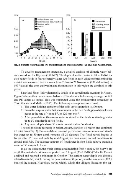
- Page 204 and 205: 1. There are possibilities of growi
- Page 208 and 209: Table 9. Yield a of preflood ahu (a
- Page 210 and 211: Grain yield (t ha -1 )6Farmers’ l
- Page 212 and 213: ReferencesIRRI (International Rice
- Page 214 and 215: network (Sastry 1976). Temperature
- Page 216 and 217: Temperature (°C) and solar radiati
- Page 218 and 219: Table 1. Characterization of rainfa
- Page 220 and 221: in eastern Uttar Pradesh under norm
- Page 222 and 223: fluctuations/variations in rainfall
- Page 224 and 225: the desirable rainfall period at 50
- Page 226 and 227: The radiation values range from les
- Page 228 and 229: not affect the growth and developme
- Page 230 and 231: Agrohydrologic and drought riskanal
- Page 232 and 233: Analytical procedureThe nature and
- Page 234 and 235: late because of low rainfall at the
- Page 236 and 237: Probability (%)10080604020Vegetativ
- Page 238 and 239: 15 August), which may happen twice
- Page 240 and 241: texture), then once in two years (5
- Page 242 and 243: Characterizing biotic stresses
- Page 244 and 245: Characterizing biotic constraintsto
- Page 246 and 247: included in these studies. Later st
- Page 248 and 249: Average number of insects per sweep
- Page 250 and 251: Table 2. Categorization of weed and
- Page 252 and 253: Table 5. Properties of individual c
- Page 254 and 255: ResultsRelations among pests and cr
- Page 256 and 257:
Start hereInterview farmers todocum
- Page 258 and 259:
Table 10. Information used to prior
- Page 260 and 261:
Interpreting the results of indepen
- Page 262 and 263:
level. Again, we augment our databa
- Page 264 and 265:
NotesAuthors’ address: Cambodia-I
- Page 266 and 267:
in soil nutritional status, especia
- Page 268 and 269:
flora. The range in elevation acros
- Page 270 and 271:
Table 1. Soil characteristics of th
- Page 272 and 273:
Table 3. Weed species recorded and
- Page 274 and 275:
Proportional abundance (log scale)%
- Page 276 and 277:
1.0Echi_colCype_iriMoll_penLind_spp
- Page 278 and 279:
+3.0Echi_cruMars_creEcli_albLept_ch
- Page 280 and 281:
indicates the need to deploy broad-
- Page 282 and 283:
ReferencesBangun P, Pane H, Jatmiko
- Page 284 and 285:
Socioeconomic characterization
- Page 286 and 287:
The role of characterizationin ex a
- Page 288 and 289:
ApproachThe following steps were ta
- Page 290 and 291:
PriceDS 0S 1P 0P 1dS 0S 1acbD0 Q 0Q
- Page 292 and 293:
Table 1. Ex ante assessment of rese
- Page 294 and 295:
Table 2 continued.Ranked byResearch
- Page 296 and 297:
Table 3. Research resource allocati
- Page 298 and 299:
NotesAuthors’ address: National C
- Page 300 and 301:
In addition to the unavailability o
- Page 302 and 303:
Socioeconomic constraintsFarm sizeF
- Page 304 and 305:
found that a higher rural labor sup
- Page 306 and 307:
Table 3. Rice area under HYVs from
- Page 308 and 309:
Rice varieties in farmers’ fields
- Page 310 and 311:
Table 9. Constraints for low adopti
- Page 312 and 313:
vehicle for realizing the untapped
- Page 314 and 315:
Parthasarathy G, Prasad DS. 1978. R
- Page 316 and 317:
Appendix. Agroclimatic zones of Bih
- Page 318 and 319:
such that losses are reduced during
- Page 320 and 321:
P = 0.5 R [a 2 C r2+ 2 a (1 - a) g
- Page 322 and 323:
and Itgaon, however, the plot-level
- Page 324 and 325:
espectively, to farmers’ income.
- Page 326 and 327:
Factors determining the adoption of
- Page 328 and 329:
mining whether or not modern variet
- Page 330 and 331:
irrigation schemes in the study are
- Page 332 and 333:
Using gender analysis in characteri
- Page 334 and 335:
lytical tool used to identify or di
- Page 336 and 337:
However, household members have cer
- Page 338 and 339:
Table 1. Village characteristics of
- Page 340 and 341:
taking care of dairy cattle. On the
- Page 342 and 343:
The biophysical environmentThe perf
- Page 344 and 345:
Table 3. Seasonal calendar and gend
- Page 346 and 347:
Table 4. Crops grown during the kha
- Page 348 and 349:
Table 7. Labor input (person-days h
- Page 350 and 351:
Table 8. Labor input (person-days h
- Page 352 and 353:
Table 10. Cost and returns of rice
- Page 354 and 355:
Gender roles in animal husbandryWhe
- Page 356 and 357:
farm activities, 25% in nonfarm act
- Page 358 and 359:
for rice but also for cash crops su
- Page 360 and 361:
Table 15. Access to agricultural in
- Page 362 and 363:
Hossain M. 1995. Recent development
- Page 364 and 365:
Agricultural commercializationand l
- Page 366 and 367:
Conceptual frameworkPopulation pres
- Page 368 and 369:
tional average of 18% 1 , and most
- Page 370 and 371:
The Dzao live in medium-altitude ar
- Page 372 and 373:
Table 1. Selected districts and com
- Page 374 and 375:
Table 2. General characteristics of
- Page 376 and 377:
markets for their food needs. With
- Page 378 and 379:
ther “extensification” in the u
- Page 380 and 381:
the productivity of lowland rice ca
- Page 382 and 383:
Boserup E. 1981. Population and tec
- Page 384 and 385:
Economics of intensive rainfed lowl
- Page 386 and 387:
Area (ha)50,00040,000Irrigated30,00
- Page 388 and 389:
The economic characterization and i
- Page 390 and 391:
Table 1. Rice varieties planted (19
- Page 392 and 393:
Table 4. Yield and input use of maj
- Page 394 and 395:
TFP, output and input indices200160
- Page 396 and 397:
Lynam JK, Herdt RW. 1989. Sense and
- Page 398 and 399:
406 Garcia et al
- Page 400 and 401:
Increased rice production had alway
- Page 402 and 403:
Table 1. Total rice area, average y
- Page 404 and 405:
use of water by avoiding seedbed pr
- Page 406 and 407:
water often brought with it a varie
- Page 408 and 409:
Table 4. Distribution of farm house
- Page 410 and 411:
Soil types found in the villages we
- Page 412 and 413:
Table 10. Ownership of agricultural
- Page 414 and 415:
in a group) at the rate of $60 per
- Page 416 and 417:
Table 13. Pattern of loan use (% of
- Page 418 and 419:
Labor and employmentTable 16 presen
- Page 420 and 421:
Table 17. Incidence of child labor
- Page 422 and 423:
Cumulative proportion of income1.04
- Page 424 and 425:
Table 21. Cost and return analysis
- Page 426 and 427:
Table 22. Estimated rice yield and
- Page 428 and 429:
were often burned for disease contr
- Page 430 and 431:
landless population reaching 50-60%
- Page 432 and 433:
Integration of biophysical andsocio
- Page 434 and 435:
opinion regarding what socioeconomi
- Page 436 and 437:
1995-96 Rice production (t)TvRd6Rd1
- Page 438 and 439:
Farm-gate price of agricultural goo
- Page 440 and 441:
ming the distance of all line segme
- Page 442 and 443:
Description of the study areaWe com
- Page 444 and 445:
Table 1 continued.Variable Unit1994
- Page 446 and 447:
CambodiaFig. 4. Main transport rout
- Page 448 and 449:
Table 2. Accessibility indicators f
- Page 450 and 451:
ice and the model is applied to exp
- Page 452 and 453:
Table 3. Summary of estimates of la
- Page 454 and 455:
estimation of a system of multinomi
- Page 456 and 457:
The availability of low-saline irri
- Page 458 and 459:
Table 5. Simulation of effects of i
- Page 460 and 461:
NotesAuthors’ address: Social Sci
- Page 462 and 463:
that they synthesize fragmented agr
- Page 464 and 465:
Framework for exploratory and predi
- Page 466 and 467:
and quantify the spatial distributi
- Page 468 and 469:
Seventeen different agricultural pr
- Page 470 and 471:
self-sufficiency in rice production
- Page 472 and 473:
al warming since maintaining or cre
- Page 474 and 475:
eturns to purchased inputs due to u
- Page 476 and 477:
Francisco SR, Navarrete Jr. RL, Dim
- Page 478:
Wade L. 1998. Nutrient research on