

Precipitation-Runoff and Streamflow-Routing Models for the ...
Precipitation-Runoff and Streamflow-Routing Models for the ...
Precipitation-Runoff and Streamflow-Routing Models for the ...
- No tags were found...

You also want an ePaper? Increase the reach of your titles
YUMPU automatically turns print PDFs into web optimized ePapers that Google loves.
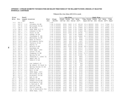
APPENDIX 1. STREAM GEOMETRY FOR MAIN STEM AND MAJOR TRIBUTARIES OF THE WILLAMETTE RIVER, OREGON, AT SELECTEDINTERVALS—CONTINUEDWillamette River from Albany (RM 119.5) to mouth95River Reach | Low Flow | High Flow |Mile Sta. Length Location Elev Slope Disch. Width Vel. Area Time Disch. Width Vel. Area Time(mi) (ft) (ft/ft) (ft 3 /s) (ft) (ft/s) (ft 2 ) (hrs)(ft 3 /s) (ft) (ft/s) (ft 2 ) (hrs)0.0 201.2 Mouth 1.801.2 200.0 1.2 Columbia SL-RB 1.84 0.000006 8350 1400 0.17 49118 10.4 385000 3500 5.4 71944 0.33.4 197.8 2.2 Multnomah Ch-LB 1.90 0.000005 8330 1700 0.17 49000 19.0 385000 3000 5.4 71944 0.67.0 194.2 3.6 RR Bridge 2.00 0.000005 8330 1300 0.22 37864 24.0 385000 2500 6.5 59462 0.812.8 188.4 5.8 USGS Gage 2117.2 2.20 0.000007 8330 1300 0.22 37864 38.7 385000 2500 6.5 59462 1.318.5 182.7 5.7 Johnson Cr-RB 3.36 0.000039 8330 1500 0.22 37864 38.0 385000 2500 6.5 59462 1.320.2 181.0 1.7 Tryon Cr-LB 3.71 0.000039 8310 1000 0.33 25182 7.6 385000 2500 6.5 59462 0.421.1 180.1 0.9 Oswego Lk-LB 3.89 0.000038 8310 550 0.44 18886 3.0 385000 2000 6.5 59462 0.224.8 176.4 3.7 Clackamas R -RB 4.65 0.000039 8310 900 0.44 18886 12.3 385000 2500 6.5 59462 0.825.4 175.8 0.6 Abernethy Cr-RB 4.77 0.000038 7610 400 0.90 8456 1.0 351000 2000 5.7 61598 0.226.5 174.7 1.1 Base of Falls 5.00 0.000040 7600 625 0.90 8444 1.8 351000 2000 5.7 61598 0.326.6 174.6 0.1 Willamette Falls 54.00 0.092803 7600 625 6.00 1267 0.0 351000 2000 9.7 36285 0.028.4 172.8 1.8 Tualatin R-LB 54.13 0.000014 7600 825 0.55 13818 4.8 351000 2000 5.6 62310 0.529.0 172.2 0.6 Beaver Cr 54.18 0.000016 7460 1000 0.52 14346 1.7 326000 2500 5.5 59787 0.235.7 165.5 6.7 Molalla R-RB 54.75 0.000016 7460 1000 0.52 14346 18.9 326000 2500 5.8 56538 1.737.6 163.6 1.9 Boeckman-LB 54.92 0.000017 7300 625 0.55 13273 5.1 305000 2500 5.6 54468 0.538.5 162.7 0.9 USGS Gage, 1980 55.02 0.000021 7300 600 0.55 13273 2.4 305000 2500 5.6 54468 0.239.8 161.4 1.3 Corral Cr-LB 55.20 0.000026 7300 600 0.66 11061 2.9 305000 2500 5.6 54468 0.345.1 156.1 5.3 Champoeg Cr-RB 56.28 0.000039 7300 650 0.66 11061 11.8 305000 2500 5.6 54468 1.447.4 153.8 2.3 Spring Br-LB 56.80 0.000043 7290 600 0.66 11045 5.1 305000 2500 5.6 54468 0.650.8 150.4 3.4 Chehalem C, lower Is 57.62 0.000046 7290 600 1.50 4860 3.3 305000 2500 5.6 54468 0.952.4 148.8 1.6 Upper Ash Is 58.20 0.000069 7290 525 1.50 4860 1.6 305000 2500 5.6 54468 0.454.9 146.3 2.5 Yamhill R-LB 60.00 0.000136 7290 600 1.50 4860 2.4 305000 2500 5.6 54468 0.760.0 141.2 5.1 68.00 0.000297 7170 550 4.55 1576 1.6 285000 2000 8.4 34020 0.964.9 136.3 4.9 Low Lambert Sl 76.40 0.000325 7170 500 7.90 908 0.9 285000 2000 8.4 34020 0.970.9 130.3 6.0 Up Lmbert Sl-Grnd Is 89.50 0.000414 7170 600 7.90 908 1.1 285000 2000 8.4 34020 1.173.5 127.7 2.6 Spring Valley Cr-LB 95.30 0.000422 7170 650 4.50 1593 0.8 285000 2000 8.4 34020 0.579.6 121.6 6.1 Glenn Cr-LB 102.00 0.000208 7160 800 3.10 2310 2.9 285000 2000 8.4 34020 1.183.6 117.6 4.0 Mill Cr-RB 110.60 0.000407 7160 700 3.10 2310 1.9 285000 2000 8.4 34020 0.784.1 117.1 0.5 USGS Gage, 1910 111.40 0.000303 7060 800 2.60 2715 0.3 283000 2000 8.4 33856 0.186.0 115.2 1.9 Pettijohn Cr-RB 113.20 0.000179 7060 600 2.60 2715 1.1 283000 2000 8.4 33856 0.388.1 113.1 2.1 Rickreall Cr-LB 115.30 0.000189 7060 550 2.60 2715 1.2 283000 2000 8.4 33856 0.495.3 105.9 7.2 Ash Cr-LB 128.00 0.000334 7050 600 2.90 2431 3.6 281000 2000 8.3 33690 1.3101.3 99.9 6.0 Bashaw Cr-RB 140.20 0.000385 7050 600 2.90 2431 3.0 281000 2000 8.3 33690 1.1101.5 99.7 0.2 Sydney Ditch-RB 140.60 0.000400 7050 600 2.90 2431 0.1 281000 2000 8.3 33690 0.0107.5 93.7 6.0 Luckiamute R-LB 154.00 0.000422 7050 600 2.90 2431 3.0 281000 2000 8.3 33690 1.1108.0 93.2 0.5 L Santiam R -RB 155.30 0.000492 7010 500 3.15 2225 0.2 279000 2000 8.3 33525 0.1109.0 92.2 1.0 Santiam R-RB 157.40 0.000398 7010 400 2.40 2921 0.6 279000 2000 8.3 33525 0.2115.5 85.7 6.5 Fourth Lake-RB 169.20 0.000344 5160 450 1.65 3127 5.8 168000 2000 7.6 21970 1.2117.9 83.3 2.4 Cox & Periwinkle Crs 172.70 0.000276 5160 375 1.65 3127 2.1 168000 2000 7.6 21970 0.5119.3 81.9 1.4 USGS Gage, 1740 174.70 0.000271 5160 500 1.65 3127 1.2 168000 2000 7.6 21970 0.3


