Precipitation-Runoff and Streamflow-Routing Models for the ...
Precipitation-Runoff and Streamflow-Routing Models for the ...
Precipitation-Runoff and Streamflow-Routing Models for the ...
- No tags were found...
Create successful ePaper yourself
Turn your PDF publications into a flip-book with our unique Google optimized e-Paper software.
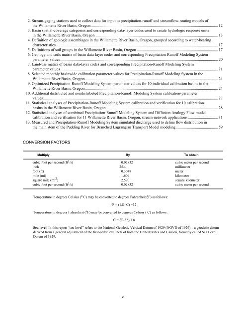
2. Stream-gaging stations used to collect data <strong>for</strong> input to precipitation-runoff <strong>and</strong> streamflow-routing models of<strong>the</strong> Willamette River Basin, Oregon .............................................................................................................................. 123. Basin spatial-coverage categories <strong>and</strong> corresponding data-layer codes used to create hydrologic response unitsin <strong>the</strong> Willamette River Basin, Oregon .......................................................................................................................... 134. Definition of geologic assemblages in <strong>the</strong> Willamette River Basin, Oregon, grouped according to water-bearingcharacteristics ................................................................................................................................................................. 175. Definitions of soil groups in <strong>the</strong> Willamette River Basin, Oregon ................................................................................. 176. Geology <strong>and</strong> soils matrix of basin data-layer codes <strong>and</strong> corresponding <strong>Precipitation</strong>-<strong>Runoff</strong> Modeling Systemparameter values............................................................................................................................................................. 207. L<strong>and</strong>-use matrix of basin data-layer codes <strong>and</strong> corresponding <strong>Precipitation</strong>-<strong>Runoff</strong> Modeling Systemparameter values............................................................................................................................................................. 218. Selected monthly basinwide calibration parameter values <strong>for</strong> <strong>Precipitation</strong>-<strong>Runoff</strong> Modeling System in <strong>the</strong>Willamette River Basin, Oregon .................................................................................................................................... 249. Optimized <strong>Precipitation</strong>-<strong>Runoff</strong> Modeling System parameter values <strong>for</strong> 10 individual calibration basins in <strong>the</strong>Willamette River Basin, Oregon .................................................................................................................................... 2410. Additional distributed <strong>and</strong> nondistributed <strong>Precipitation</strong>-<strong>Runoff</strong> Modeling System calibration-parametervalues.............................................................................................................................................................................. 2711. Statistical analyses of <strong>Precipitation</strong>-<strong>Runoff</strong> Modeling System calibration <strong>and</strong> verification <strong>for</strong> 10 calibrationbasins in <strong>the</strong> Willamette River Basin, Oregon ............................................................................................................... 2812. Statistical analyses of combined <strong>Precipitation</strong>-<strong>Runoff</strong> Modeling System <strong>and</strong> Diffusion Analogy Flow modelcalibration <strong>and</strong> verification <strong>for</strong> 11 Willamette River Basin, Oregon, stream-network applications.............................. 3113. Measured <strong>and</strong> <strong>Precipitation</strong>-<strong>Runoff</strong> Modeling System simulated discharge used to define flow distribution in<strong>the</strong> main stem of <strong>the</strong> Pudding River <strong>for</strong> Branched Lagrangian Transport Model modeling.......................................... 59CONVERSION FACTORSMultiply By To obtaincubic foot per second (ft 3 /s) 0.02832 cubic meter per secondinch 25.4 millimeterfoot (ft) 0.3048 metermile (mi) 1.609 kilometersquare mile (mi 2 ) 2.590 square kilometercubic foot per second (ft 3 /s) 0.02832 cubic meter per secondTemperature in degrees Celsius ( o C) may be converted to degrees Fahrenheit ( o F) as follows:o F = (1.8 o C) +32Temperature in degrees Fahrenheit ( o F) may be converted to degrees Celsius ( C) as follows:C = ( o F-32)/1.8Sea level: In this report “sea level” refers to <strong>the</strong> National Geodetic Vertical Datum of 1929 (NGVD of 1929)—a geodetic datumderived from a general adjustment of <strong>the</strong> first-order level nets of both <strong>the</strong> United States <strong>and</strong> Canada, <strong>for</strong>merly called Sea LevelDatum of 1929.VI


