

Precipitation-Runoff and Streamflow-Routing Models for the ...
Precipitation-Runoff and Streamflow-Routing Models for the ...
Precipitation-Runoff and Streamflow-Routing Models for the ...
- No tags were found...

You also want an ePaper? Increase the reach of your titles
YUMPU automatically turns print PDFs into web optimized ePapers that Google loves.
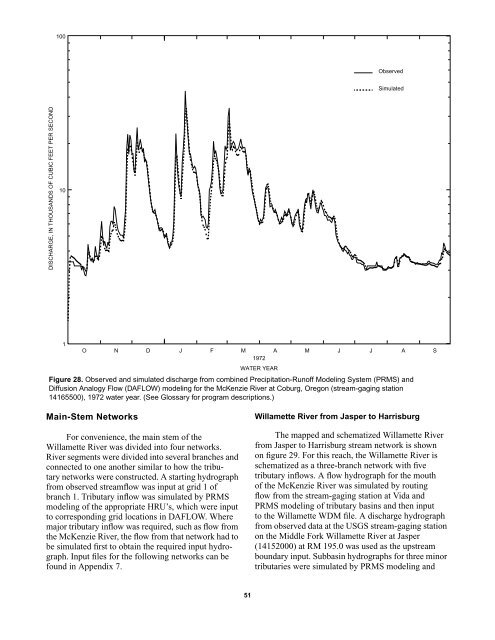
100ObservedSimulatedDISCHARGE, IN THOUSANDS OF CUBIC FEET PER SECOND101O N D J F M A M J J A S1972WATER YEARFigure 28. Observed <strong>and</strong> simulated discharge from combined <strong>Precipitation</strong>-<strong>Runoff</strong> Modeling System (PRMS) <strong>and</strong>Diffusion Analogy Flow (DAFLOW) modeling <strong>for</strong> <strong>the</strong> McKenzie River at Coburg, Oregon (stream-gaging station14165500), 1972 water year. (See Glossary <strong>for</strong> program descriptions.)Main-Stem NetworksFor convenience, <strong>the</strong> main stem of <strong>the</strong>Willamette River was divided into four networks.River segments were divided into several branches <strong>and</strong>connected to one ano<strong>the</strong>r similar to how <strong>the</strong> tributarynetworks were constructed. A starting hydrographfrom observed streamflow was input at grid 1 ofbranch 1. Tributary inflow was simulated by PRMSmodeling of <strong>the</strong> appropriate HRU’s, which were inputto corresponding grid locations in DAFLOW. Wheremajor tributary inflow was required, such as flow from<strong>the</strong> McKenzie River, <strong>the</strong> flow from that network had tobe simulated first to obtain <strong>the</strong> required input hydrograph.Input files <strong>for</strong> <strong>the</strong> following networks can befound in Appendix 7.Willamette River from Jasper to HarrisburgThe mapped <strong>and</strong> schematized Willamette Riverfrom Jasper to Harrisburg stream network is shownon figure 29. For this reach, <strong>the</strong> Willamette River isschematized as a three-branch network with fivetributary inflows. A flow hydrograph <strong>for</strong> <strong>the</strong> mouthof <strong>the</strong> McKenzie River was simulated by routingflow from <strong>the</strong> stream-gaging station at Vida <strong>and</strong>PRMS modeling of tributary basins <strong>and</strong> <strong>the</strong>n inputto <strong>the</strong> Willamette WDM file. A discharge hydrographfrom observed data at <strong>the</strong> USGS stream-gaging stationon <strong>the</strong> Middle Fork Willamette River at Jasper(14152000) at RM 195.0 was used as <strong>the</strong> upstreamboundary input. Subbasin hydrographs <strong>for</strong> three minortributaries were simulated by PRMS modeling <strong>and</strong>51


