

Precipitation-Runoff and Streamflow-Routing Models for the ...
Precipitation-Runoff and Streamflow-Routing Models for the ...
Precipitation-Runoff and Streamflow-Routing Models for the ...
- No tags were found...

Create successful ePaper yourself
Turn your PDF publications into a flip-book with our unique Google optimized e-Paper software.
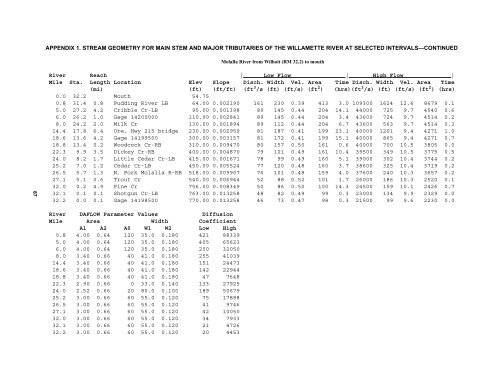
APPENDIX 1. STREAM GEOMETRY FOR MAIN STEM AND MAJOR TRIBUTARIES OF THE WILLAMETTE RIVER AT SELECTED INTERVALS—CONTINUEDMolalla River from Wilhoit (RM 32.2) to mouth87River Reach | Low Flow | High Flow |Mile Sta. Length Location Elev Slope Disch. Width Vel. Area Time Disch. Width Vel. Area Time(mi) (ft) (ft/ft) (ft 3 /s (ft) (ft/s) (ft 2 ) (hrs)(ft 3 /s) (ft) (ft/s) (ft 2 ) (hrs)0.0 32.2 Mouth 54.750.8 31.4 0.8 Pudding River LB 64.00 0.002190 161 230 0.39 413 3.0 109300 1624 12.6 8679 0.15.0 27.2 4.2 Cribble Cr-LB 95.00 0.001398 89 145 0.44 204 14.1 44000 725 9.7 4540 0.66.0 26.2 1.0 Gage 14200000 110.00 0.002841 89 145 0.44 204 3.4 43600 724 9.7 4514 0.28.0 24.2 2.0 Milk Cr 130.00 0.001894 89 112 0.44 204 6.7 43600 563 9.7 4514 0.314.4 17.8 6.4 Ore. Hwy 215 bridge 230.00 0.002959 81 187 0.41 199 23.1 40000 1201 9.4 4271 1.018.6 13.6 4.2 Gage 14199500 300.00 0.003157 81 172 0.41 199 15.1 40000 865 9.4 4271 0.718.8 13.4 0.2 Woodcock Cr-RB 310.00 0.009470 80 157 0.50 161 0.6 40000 700 10.5 3805 0.022.3 9.9 3.5 Dickey Cr-RB 400.00 0.004870 79 101 0.49 161 10.4 39500 349 10.5 3775 0.524.0 8.2 1.7 Little Cedar Cr-LB 415.00 0.001671 78 99 0.49 160 5.1 39000 302 10.4 3744 0.225.2 7.0 1.2 Cedar Cr-LB 450.00 0.005524 77 120 0.48 160 3.7 38600 325 10.4 3719 0.226.5 5.7 1.3 N. Fork Molalla R-RB 518.00 0.009907 76 101 0.48 159 4.0 37600 240 10.3 3657 0.227.1 5.1 0.6 Trout Cr 540.00 0.006944 52 88 0.52 101 1.7 26000 186 10.3 2520 0.132.0 0.2 4.9 Pine Cr 756.00 0.008349 50 86 0.50 100 14.3 24500 159 10.1 2426 0.732.1 0.1 0.1 Shotgun Cr-LB 763.00 0.013258 48 82 0.49 99 0.3 23000 134 9.9 2329 0.032.2 0.0 0.1 Gage 14198500 770.00 0.013258 46 73 0.47 98 0.3 21500 99 9.6 2230 0.0River DAFLOW Parameter Values DiffusionMile Area Width CoefficientA1 A2 A0 W1 W2 Low High0.8 4.00 0.64 120 35.0 0.180 421 883395.0 4.00 0.64 120 35.0 0.180 405 656236.0 4.00 0.64 120 35.0 0.180 200 320508.0 3.40 0.66 40 41.0 0.180 255 4103914.4 3.40 0.66 40 41.0 0.180 151 2447318.6 3.40 0.66 40 41.0 0.180 142 2294418.8 3.40 0.66 40 41.0 0.180 47 764822.3 2.90 0.66 0 33.0 0.140 133 2792524.0 2.52 0.66 20 80.0 0.100 189 5067925.2 3.00 0.66 60 55.0 0.120 75 1788826.5 3.00 0.66 60 55.0 0.120 41 974627.1 3.00 0.66 60 55.0 0.120 42 1005032.0 3.00 0.66 60 55.0 0.120 34 793332.1 3.00 0.66 60 55.0 0.120 21 472632.2 3.00 0.66 60 55.0 0.120 20 4453


