

Precipitation-Runoff and Streamflow-Routing Models for the ...
Precipitation-Runoff and Streamflow-Routing Models for the ...
Precipitation-Runoff and Streamflow-Routing Models for the ...
- No tags were found...

Create successful ePaper yourself
Turn your PDF publications into a flip-book with our unique Google optimized e-Paper software.
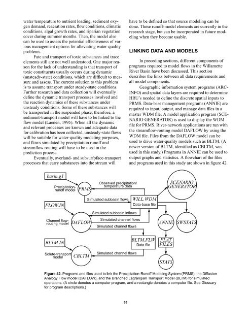
water temperature to nutrient loading, sediment oxygendem<strong>and</strong>, reaeration rates, flow conditions, climaticconditions, algal growth rates, <strong>and</strong> riparian vegetationcover during summer months. Then, <strong>the</strong> model alsocan be used to assess <strong>the</strong> potential effectiveness of variousmanagement options <strong>for</strong> alleviating water-qualityproblems.Fate <strong>and</strong> transport of toxic substances <strong>and</strong> traceelements still are not well understood. One major reason<strong>for</strong> <strong>the</strong> lack of underst<strong>and</strong>ing is that transport oftoxic constituents usually occurs during dynamic(unsteady-state) conditions, which are difficult to measure<strong>and</strong> assess. The current solution to this problemis to assume transport under steady-state conditions.Fur<strong>the</strong>r research <strong>and</strong> data collection will eventuallydefine <strong>the</strong> dynamic transport processes involved <strong>and</strong><strong>the</strong> reaction dynamics of <strong>the</strong>se substances underunsteady conditions. Some of <strong>the</strong>se substances willbe transported in <strong>the</strong> suspended phase; <strong>the</strong>re<strong>for</strong>e, asediment-transport model will have to be linked to <strong>the</strong>flow model (Laenen, 1995). When all <strong>the</strong> dynamic<strong>and</strong> relevant processes are known <strong>and</strong> adequate data<strong>for</strong> calibration has been collected, unsteady-state flowswill be suitable <strong>for</strong> water-quality modeling purposes,<strong>and</strong> flows simulated by precipitation runoff <strong>and</strong>streamflow routing will have to be used in <strong>the</strong>prediction process.Eventually, overl<strong>and</strong>- <strong>and</strong> subsurfpface-transportprocesses that carry substances into <strong>the</strong> stream willhave to be defined so that source modeling can bedone. These runoff-model elements are currently in <strong>the</strong>research stage, but can be incorporated in future modelingwhen <strong>the</strong>y become usable.LINKING DATA AND MODELSIn preceding sections, different components ofprograms required to model flows in <strong>the</strong> WillametteRiver Basin have been discussed. This sectiondescribes <strong>the</strong> links between all data requirements <strong>and</strong>all model components.Geographic in<strong>for</strong>mation system programs (ARC-INFO) <strong>and</strong> spatial data layers are required to determineHRU’s needed to define <strong>the</strong> discrete spatial inputs toPRMS. Data-base management programs (ANNIE) arerequired to input, output, <strong>and</strong> manage data files in amaster WDM file. A model application program (SCE-NARIO GENERATOR) is used to display <strong>the</strong> WDMfile <strong>for</strong> PRMS. River-network applications are run with<strong>the</strong> streamflow-routing model DAFLOW by using <strong>the</strong>WDM file. Files from <strong>the</strong> DAFLOW model can beused to drive water-quality models such as BLTM. (Anewer version of BLTM, identified as CBLTM, wasused in this study.) Programs in ANNIE can be used tooutput graphs <strong>and</strong> statistics. A flowchart of <strong>the</strong> files<strong>and</strong> programs used in this study are shown in figure 42.basin.g1<strong>Precipitation</strong>runoffmodelPRMSObserved precipitation/temperature dataSCENARIOGENERATORFLOW.INSimulated subbasin flows WILL.WDMData-base fileWILL.WDSimulated subbasin inflowsSimulated channel flowsDAFLOWSimulated channel flowsChannel flowroutingmodelANNIESWSTATSBLTM.INBLTM.FLWData fileFLATFILESSolute-transportmodelCBLTMSimulated channel flowsSTATSFigure 42. Programs <strong>and</strong> files used to link <strong>the</strong> <strong>Precipitation</strong>-<strong>Runoff</strong> Modeling System (PRMS), <strong>the</strong> DiffusionAnalogy Flow model (DAFLOW), <strong>and</strong> <strong>the</strong> Branched Lagrangian Transport Model (BLTM) <strong>for</strong> simulatedoperations. (A circle denotes a computer program, <strong>and</strong> a rectangle denotes a computer file. See Glossary<strong>for</strong> program descriptions.)63


