

Precipitation-Runoff and Streamflow-Routing Models for the ...
Precipitation-Runoff and Streamflow-Routing Models for the ...
Precipitation-Runoff and Streamflow-Routing Models for the ...
- No tags were found...

Create successful ePaper yourself
Turn your PDF publications into a flip-book with our unique Google optimized e-Paper software.
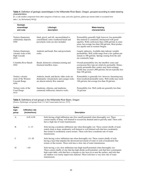
Table 4. Definition of geologic assemblages in <strong>the</strong> Willamette River Basin, Oregon, grouped according to water-bearingcharacteristics[#, a code number component from o<strong>the</strong>r categories of l<strong>and</strong> use, slope, <strong>and</strong> soils; [gal/min, gallons per minute (table is excerpted fromtable 1, by McFarl<strong>and</strong> [1983])]________________________________________________________________________________________________Geologicassemblage Lithologic Water-bearing<strong>and</strong> code description characteristics________________________________________________________________________________________________Tertiary-Quaternary S<strong>and</strong>, gravel, <strong>and</strong> silt, unconsolidated to Permeability generally high; however, less permeablesedimentary deposits consolidated; some wea<strong>the</strong>red basalt <strong>and</strong> fine material is commonly interlayered with good##0# pyroclastic rocks are also included. aquifers. Wells yield more than 2,000 gal/min in someareas, but average less than 300 gal/min. Most productiveaquifer unit in western Oregon.Tertiary-Quaternary Andesite <strong>and</strong> basalt, flow <strong>and</strong> pyroclastic Largely unknown. Available data indicate variablevolcanic rocks of <strong>the</strong> rocks. permeability. Well yields range from a few gallons perHigh Cascademinute to 300 gal/min. Springs issuing from <strong>the</strong> unit##3# are commonly large.Columbia River Basalt Basalt; distinctive columnar jointing <strong>and</strong> Overall permeability low, but interflow zones <strong>and</strong>##6# fractured interflow zones. scoriaceous flow tops are relatively permeable. Dense,poorly permeable flow centers may limit recharge.Yields may exceed 1,000 gal/min, but are typically lessthan 100 gal/min.Tertiary volcanic Andesite, basalt, <strong>and</strong> dacite; older rocks are Permeability is generally low; however, fracturing mayrocks of <strong>the</strong> Western dominantly volcaniclastic <strong>and</strong> younger rocks <strong>for</strong>m localized permeable zones. Well yields may reachCascade Range are almost entirely flow material. 100 gal/min, but average less than 20 gal/min.##9#Tertiary rocks of <strong>the</strong> S<strong>and</strong>stone, siltstone, <strong>and</strong> mudstone, Permeability low. Well yields are generally less thanCoast Range commonly tuffaceous; intrusive rocks. 10 gal/min.##1#________________________________________________________________________________________________Table 5. Definitions of soil groups in <strong>the</strong> Willamette River Basin, Oregon[Source: Hydrologic soil groups from U.S. Soil Conservation Service, 1975]________________________________________________________________________________________________HydrologicInfiltration rategroup [inches/hour] Description________________________________________________________________________________________________A 0.45–0.30 Soils having a high infiltration rate (low runoff potential) when thoroughly wet. Theseconsist mainly of deep, well drained to excessively drained s<strong>and</strong> or gravelly s<strong>and</strong>. These soilshave a high rate of water transmission.B .3–.15 Soils having a moderate infiltration rate when thoroughly wet. These consist chiefly of moderatelydeep or deep, moderately well drained or well drained soils that have moderatelyfine texture to moderately coarse texture. These soils have a moderate rate of watertransmission.C .15–.05 Soils having a slow infiltration rate when thoroughly wet. These consist chiefly of soilshaving a layer that impedes <strong>the</strong> downward movement of water or soils of moderately finetexture or fine texture. These soils have a slow rate of water transmission.D


