Precipitation-Runoff and Streamflow-Routing Models for the ...
Precipitation-Runoff and Streamflow-Routing Models for the ...
Precipitation-Runoff and Streamflow-Routing Models for the ...
- No tags were found...
You also want an ePaper? Increase the reach of your titles
YUMPU automatically turns print PDFs into web optimized ePapers that Google loves.
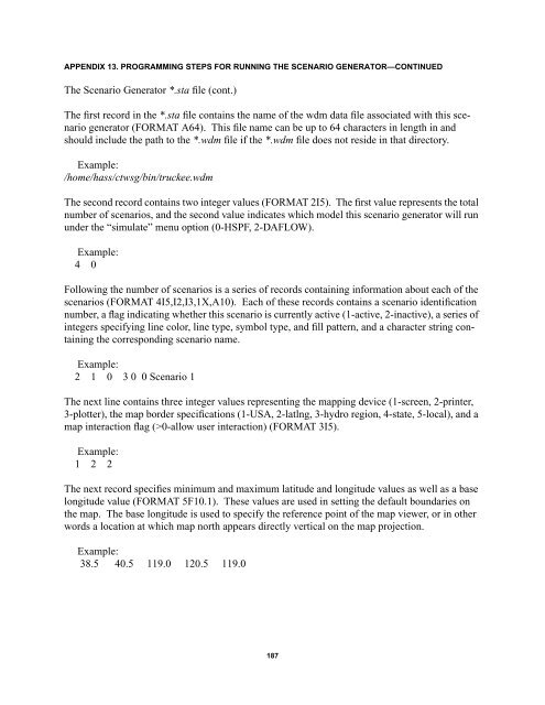
APPENDIX 13. PROGRAMMING STEPS FOR RUNNING THE SCENARIO GENERATOR—CONTINUEDThe Scenario Generator *.sta file (cont.)The first record in <strong>the</strong> *.sta file contains <strong>the</strong> name of <strong>the</strong> wdm data file associated with this scenariogenerator (FORMAT A64). This file name can be up to 64 characters in length in <strong>and</strong>should include <strong>the</strong> path to <strong>the</strong> *.wdm file if <strong>the</strong> *.wdm file does not reside in that directory.Example:/home/hass/ctwsg/bin/truckee.wdmThe second record contains two integer values (FORMAT 2I5). The first value represents <strong>the</strong> totalnumber of scenarios, <strong>and</strong> <strong>the</strong> second value indicates which model this scenario generator will rununder <strong>the</strong> “simulate” menu option (0-HSPF, 2-DAFLOW).Example:4 0Following <strong>the</strong> number of scenarios is a series of records containing in<strong>for</strong>mation about each of <strong>the</strong>scenarios (FORMAT 4I5,I2,I3,1X,A10). Each of <strong>the</strong>se records contains a scenario identificationnumber, a flag indicating whe<strong>the</strong>r this scenario is currently active (1-active, 2-inactive), a series ofintegers specifying line color, line type, symbol type, <strong>and</strong> fill pattern, <strong>and</strong> a character string containing<strong>the</strong> corresponding scenario name.Example:2 1 0 3 0 0 Scenario 1The next line contains three integer values representing <strong>the</strong> mapping device (1-screen, 2-printer,3-plotter), <strong>the</strong> map border specifications (1-USA, 2-latlng, 3-hydro region, 4-state, 5-local), <strong>and</strong> amap interaction flag (>0-allow user interaction) (FORMAT 3I5).Example:1 2 2The next record specifies minimum <strong>and</strong> maximum latitude <strong>and</strong> longitude values as well as a baselongitude value (FORMAT 5F10.1). These values are used in setting <strong>the</strong> default boundaries on<strong>the</strong> map. The base longitude is used to specify <strong>the</strong> reference point of <strong>the</strong> map viewer, or in o<strong>the</strong>rwords a location at which map north appears directly vertical on <strong>the</strong> map projection.Example:38.5 40.5 119.0 120.5 119.0187


