

Precipitation-Runoff and Streamflow-Routing Models for the ...
Precipitation-Runoff and Streamflow-Routing Models for the ...
Precipitation-Runoff and Streamflow-Routing Models for the ...
- No tags were found...

Create successful ePaper yourself
Turn your PDF publications into a flip-book with our unique Google optimized e-Paper software.
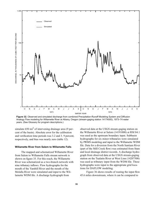
1,000ObservedSimulatedDISCHARGE, IN THOUSANDS OF CUBIC FEET PER SECOND100101O N D J F M A M J J A S O N D J F M A M J J A S1973 1974WATER YEARFigure 32. Observed <strong>and</strong> simulated discharge from combined <strong>Precipitation</strong>-<strong>Runoff</strong> Modeling System <strong>and</strong> DiffusionAnalogy Flow modeling <strong>for</strong> Willamette River at Albany, Oregon (stream-gaging station 14174000), 1973–74 wateryears. (See Glossary <strong>for</strong> program descriptions.)simulate 650 mi 2 of intervening drainage area (9 percentof <strong>the</strong> basin). Absolute error <strong>for</strong> <strong>the</strong> calibration<strong>and</strong> verification time periods was 3.2 <strong>and</strong> 3. 9 percent,respectively, <strong>and</strong> bias was nearly zero (table 12).Willamette River from Salem to Willamette FallsThe mapped <strong>and</strong> schematized Willamette Riverfrom Salem to Willamette Falls stream network isshown on figure 35. For this reach, <strong>the</strong> WillametteRiver was schematized as a two-branch network withnine tributary inflows. Flow hydrographs <strong>for</strong> <strong>the</strong>mouth of <strong>the</strong> Yamhill River <strong>and</strong> <strong>the</strong> mouth of <strong>the</strong>Molalla River were simulated <strong>and</strong> input to <strong>the</strong> WillametteWDM file. A discharge hydrograph fromobserved data at <strong>the</strong> USGS stream-gaging station on<strong>the</strong> Willamette River at Salem (14191000) at RM 84.1was used as <strong>the</strong> upstream boundary input. Subbasinhydrographs <strong>for</strong> six minor tributaries were simulatedby PRMS modeling <strong>and</strong> input to <strong>the</strong> Willamette WDMfile. Data <strong>for</strong> a diversion from <strong>the</strong> North Santiam River(part of <strong>the</strong> Mill Creek flow) was estimated from State<strong>and</strong> local drainage district records. A discharge hydrographfrom observed data at <strong>the</strong> USGS stream-gagingstation on <strong>the</strong> Tualatin River at West Linn (14207500)was used as tributary input from <strong>the</strong> WDM file. Thesehydrographs were input to <strong>the</strong> appropriate grid locations<strong>for</strong> DAFLOW modeling.Figure 36 shows results of routing <strong>the</strong> input flow45.6 miles downstream, where it can be compared to55


