

Precipitation-Runoff and Streamflow-Routing Models for the ...
Precipitation-Runoff and Streamflow-Routing Models for the ...
Precipitation-Runoff and Streamflow-Routing Models for the ...
- No tags were found...

Create successful ePaper yourself
Turn your PDF publications into a flip-book with our unique Google optimized e-Paper software.
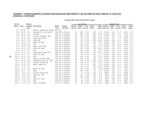
APPENDIX 1. STREAM GEOMETRY FOR MAIN STEM AND MAJOR TRIBUTARIES OF THE WILLAMETTE RIVER, OREGON, AT SELECTEDINTERVALS—CONTINUEDLong Tom River from Alvadore (25.5) to mouth79River Reach | Low Flow | High Flow |Mile Sta. Length Location Elev Slope Disch. Width Vel. Area Time Disch. Width Vel. Area Time(mi) (ft) (ft/ft) (ft 3 /s (ft) (ft/s) (ft 2 ) (hrs)(ft 3 /s) (ft) (ft/s) (ft 2 ) (hrs)0.0 25.5 Mouth (upstream mouth 238.800.6 24.9 0.6 Junction w ds mouth 242.00 0.001010 39 180 0.11 343 7.7 13000 235 5.7 2272 0.22.8 22.7 2.2 Slough 252.00 0.000861 39 200 0.09 434 35.9 13000 211 6.6 1957 0.53.3 22.2 0.5 Oliver Slough (RB) 254.00 0.000758 39 100 0.07 528 9.9 13000 194 7.2 1798 0.14.7 20.8 1.4 Gage 14170000 258.00 0.000541 39 80 0.06 622 32.8 13000 177 7.9 1638 0.36.2 19.3 1.5 Lake RB 260.00 0.000253 39 80 0.05 720 40.6 13000 166 8.1 1614 0.36.5 19.0 0.3 Base of Dam 261.00 0.000631 39 80 0.06 622 7.0 13000 166 7.9 1638 0.16.6 18.9 0.1 Dam 265.00 0.007576 39 100 0.91 43 0.2 13000 174 6.6 1972 0.06.8 18.7 0.2 Gage 14170000 265.50 0.000473 40 100 0.06 720 5.3 13000 173 8.1 1614 0.09.4 16.1 2.6 Base of Dam 276.00 0.000765 40 90 0.06 720 68.6 13000 173 8.1 1614 0.59.5 16.0 0.1 Dam 280.00 0.007576 40 150 0.92 43 0.2 13000 174 6.6 1972 0.011.9 13.6 2.4 Ferguson Creek LB 282.00 0.000158 40 90 0.06 720 63.4 13000 166 8.1 1614 0.412.0 13.5 0.1 Base of Dam 282.10 0.000189 39 90 0.05 720 2.7 13000 166 8.1 1614 0.012.1 13.4 0.1 Dam 300.00 0.033902 40 120 0.92 43 0.2 13000 164 6.6 1972 0.012.3 13.2 0.2 Drain outlet (RB) 300.50 0.000473 40 100 0.06 720 5.3 13000 159 8.1 1614 0.013.3 12.2 1.0 Ferguson Cr Alt (LB) 302.50 0.000379 39 90 0.06 620 23.3 11600 159 7.9 1467 0.213.6 11.9 0.3 Amazon Creek RB 303.00 0.000316 38 120 0.07 521 6.0 11300 151 8.1 1399 0.113.9 11.6 0.3 Bear Creek LB 304.00 0.000631 37 90 0.09 422 5.0 11000 152 8.3 1330 0.117.0 8.5 3.1 311.00 0.000428 36 60 0.11 323 40.8 10400 146 8.1 1286 0.620.1 5.4 3.1 Base of Dam 320.00 0.000550 36 60 0.89 40 5.1 10400 144 6.1 1702 0.720.2 5.3 0.1 Dam 321.00 0.001894 36 100 0.89 40 0.2 10400 144 6.1 1702 0.020.3 5.2 0.1 Coyote Creek RB 321.20 0.000379 36 60 0.05 719 2.9 10400 132 7.0 1488 0.020.4 5.1 0.1 Base of Dam 321.40 0.000379 35 60 0.05 718 3.0 9800 132 6.7 1458 0.020.5 5.0 0.1 Dam 324.00 0.004924 35 100 0.88 40 0.2 9800 131 6.0 1637 0.020.8 4.7 0.3 Base of Dam 324.80 0.000505 36 70 0.05 719 8.8 9800 132 6.7 1458 0.120.9 4.6 0.1 Dam 326.00 0.002273 36 90 0.89 40 0.2 9800 131 6.0 1637 0.022.5 3.0 1.6 Gage 14169000 330.00 0.000473 37 90 0.05 719 45.6 9800 125 6.7 1458 0.3


