Here - Stuff
Here - Stuff
Here - Stuff
You also want an ePaper? Increase the reach of your titles
YUMPU automatically turns print PDFs into web optimized ePapers that Google loves.
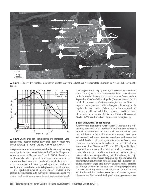
Scale0.5 g5 seconds▲▲Figure 6. Observed vertical acceleration time histories at various locations in the Christchurch region from the 22 February earthquake.Spectral acc, Sa (g)10 0 Period, T (s)10 -1Eq:22/02/2011Solid:AvgHorizDashed:Verttude of ground shaking; 2) a change in surficial soil characterization;and 3) an increase in water table depth as noted previously.Given the observed spatial extent of liquefaction in the 4September 2010 Darfield earthquake (Cubrinovski et al. 2010),in which the majority of this western region was unaffected byliquefaction despite been subjected to generally stronger shakingthan the eastern regions (where liquefaction was prevalent),it can be logically concluded that the character and in situ stateof the soils in the western Christchurch region (Brown andWeeber 1992) result in a lower liquefaction susceptibility.10 -2LPCCLPOC10 -2 10 -1 10 0 10 1▲ ▲ Figure 7. Comparison of geometric mean horizontal and verticalresponse spectra observed at two stations in Lyttelton Port,one on outcropping rock (LPCC), the other on soil (LPOC).abrupt reduction in acceleration amplitude resulting in a veryshort significant duration of 2.4 seconds (Table 1). The groundmotion observed at Hulverstone Drive (HPSC) is also of interestdue to the relatively small horizontal component accelerationamplitudes compared with what might be expectedat such a near-source location (including observed shaking atnearby stations), and relative to its high vertical accelerations.No significant signs of liquefaction are evident in theground motions recorded to the west of those discussed above,which could result from three factors: 1) a reduction in ampli-Basin-generated Surface WavesAs previously mentioned, Christchurch is located on a sedimentaryfan deposit with the volcanic rock of Banks Peninsulalocated to the southeast. While specific mechanical and geometricaldetails of the predominant sedimentary basin layersare presently unknown, previous petroleum exploration hasrevealed the depth of gravel layers is in excess of 500 m, withbasement rock inferred to be at depths in excess of 2.0 km atvarious locations (Brown and Weeber 1992, Figure 1). Figure8A provides a schematic illustration of the deep geology of theregion along a plane trending southeast to northwest. Figure8A also illustrates one possible ray path from the M w 6.3 rupturein which seismic waves propagate up-dip and enter thesedimentary basin through its thickening edge. The large postcriticalincidence angles of such waves cause reflections that leadto a waveguide effect in which surface waves propagate acrossthe basin resulting in enhanced long-period ground motionamplitudes and shaking duration (Choi et al. 2005). Figure 8Billustrates the fault-normal, fault-parallel, and geometric mean858 Seismological Research Letters Volume 82, Number 6 November/December 2011


