

Here - Stuff
Here - Stuff
Here - Stuff

You also want an ePaper? Increase the reach of your titles
YUMPU automatically turns print PDFs into web optimized ePapers that Google loves.
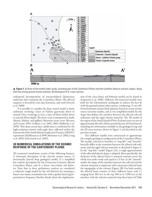
▲ ▲ Figure 1. A) Area of the model under study, including part of the Canterbury Plains and the Lyttelton-Akaroa volcanic region, alongwith the strong ground motion stations. B) Geological A-A’ cross-section.widespread decomposition of unconsolidated Quaternarysediments that constitute the Canterbury Plains. The alluvialsequence is formed by coal, clay, limestone, and sand (Forsythet al. 2008).It is possible to consider the deep crustal model as basinsediments overlying a layer of Torlesse graywacke down toaround 5 km, overlying, in turn, a layer of Haast Schist downto around 20 km depth. The lower crust is interpreted as mafic(diorite, diabase, and gabbro) Mesozoin ocean crust (Reynersand Cowan 1993; Godfrey et al. 2001, 2002; Melhuish et al.2005). This deep crustal layer subdivision is confirmed by thehigh-resolution seismic wide-angle data, collected within theframework of the South Island Geophysical Transect (SIGHT)experiment (Kleffmann et al 1998; Mortimer et al. 2002; Longet al. 2003; Scherwarth et al. 2003).3D NUMERICAL SIMULATIONS OF THE SEISMICRESPONSE OF THE CANTERBURY PLAINS3D numerical simulations consist of the following features:1) kinematic description of the close-by seismic source, 2)horizontally layered deep geological model, 3) a simplifiedbut realistic description for the Cretaceous-Cenozoic alluvialCanterbury Plains, and 4) a linear visco-elastic soil behavior.Note that in these preliminary analyses we considereda relatively rough model for the soil behavior by assuming alinear-visco elastic constitutive law, with a quality factor Q proportionalto frequency (further details about the implementationof the visco-elastic soil behavior model can be found inStupazzini et al. 2009). Different 3D numerical models werebuilt for the Christchurch earthquake to achieve the best fitwith the ground motion observations, combining: 1) two differentkinematic seismic fault solutions, based on recent seismicsource inversion studies, and 2) two simplified models for theshape that defines the interface between the alluvial soft soilsediments and the rigid volcano materials. The 3D model ofthe region of the South Island of New Zealand covers an area ofapproximately 60 x 60 x 20 km around the city of Christchurch,including the information available in the geological map andthe 2D cross-sections, shown in Figure 1 and described in theprevious section.Two different models were constructed to approximatethe complex geological configuration of the Canterbury Plains.The models, referred to hereafter as “step-like” and “smooth,”basically differ in the transition between the alluvial soft sedimentsand the rigid volcano materials, as sketched in Figure 2.In the “step-like” model (Figure 2A), a rough approximationof the alluvial-bedrock shape is adopted. More specifically, thethickness of the alluvial basin is assumed constant across thewhole area under study and equal to 1.5 km. In the “smooth”model, the shape of the interface between the soft soil and thevolcanic materials is improved, with constraints inferred fromthe topography of the volcano (Figure 2B). For both models,the alluvial basin consists of three different layers with V Sranging from 300 m/s in the top 300 m to 1,500 m/s at theinterface with the volcanic materials (top three layers of TableSeismological Research Letters Volume 82, Number 6 November/December 2011 769


