

Here - Stuff
Here - Stuff
Here - Stuff

You also want an ePaper? Increase the reach of your titles
YUMPU automatically turns print PDFs into web optimized ePapers that Google loves.
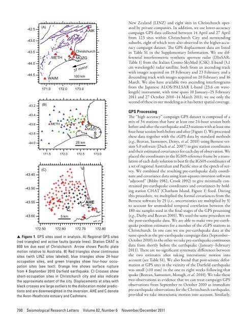
-42. 5-43. 0-43. 5-44. 0-44. 5-43.2-43.4-43.6-43.8-44.0-43.45-43.50-43.55-43.60(A)172.50171.0(B)171. 5(C)METHWAIMMETH172.0172. 0172.60C5 km100 km173.025 km172. 5172.70KAI KChristchurc hMQZG37 mm/yrMQZGAHE173. 0172.80▲ ▲ Figure 1. GPS sites used in analysis. A) Regional GPS sites(red triangles) and active faults (purple lines). Station CHAT is800 km due east of Christchurch. Arrow shows Pacific platemotion relative to Australia. B) Red triangles show continuoussites (with LINZ sites labeled), blue triangles show 24-houroccupation sites, and green triangles show four-hour occupationsites (see text). Orange line shows surface rupturefrom 4 September 2010 Darfield earthquake. C) Crosses showshort-occupation sites in Christchurch city and also indicatethe approximate extent of the city. Displacements at sites withblack crosses are large outliers to the dislocation model predictionsand are downweighted in the inversion. AHE and C denotethe Avon-Heathcote estuary and Cashmere.New Zealand (LINZ) and eight sites in Christchurch operatedby private companies. In addition, we use lower-accuracycampaign GPS data collected between 14 April and 27 Aprilfrom 123 sites within Christchurch City and surroundingsuburbs, eight of which were also observed in the higher-accuracycampaign dataset. The GPS displacement data are listedin Table S1 in the Supplementary Information. We use differentialinterferometric synthetic aperture radar (DInSAR;Table 1) from the Italian Cosmo-SkyMed (CSK) X-band (3.1cm wavelength) radar satellite, both from an ascending trackwith images acquired on 19 February and 23 February, and adescending track with images acquired on 20 February and 16March. We also have available two ascending interferogramsfrom the Japanese ALOS/PALSAR L-band (23.6 cm wavelength)instrument, with time spans 10 January–25 February2011 and 27 October 2010–14 March 2011; we use only thesecond of these in our modeling as it has better spatial coverage.GPS ProcessingThe “high accuracy” campaign GPS dataset is composed of amix of 34 stations that have at least one 24-hour session bothbefore and after the earthquake and 23 stations with at least onefour-hour session both before and after (Figure 1). We processedthese data together with the cGPS data by standard methods(e.g., Beavan, Samsonov, Denys, et al. 2010) using Bernese version5.0 software (Dach et al. 2007) to give station coordinatesand their estimated covariances for each day of observation. Weplaced the coordinates in the IGS05 reference frame by a translationof each daily solution to best fit the IGS05 coordinates ofa set of regional Australian and Pacific sites at the epoch of survey.We combined the resulting pre-earthquake daily coordinateand covariance data using least-squares inversion software“adjcoord” (Bibby 1982; Crook 1992) to give minimally constrainedpre-earthquake coordinates and covariances by holdingstation CHAT (Chatham Island, Figure 1) fixed. Duringthis procedure, we multiplied the formal covariances from theBernese software by 25 (i.e., uncertainties are multiplied by 5)to account for unmodeled temporal correlation between the180-sec samples used in the final stages of the GPS processing(e.g., Darby and Beavan 2001). We used the same procedure onthe post-earthquake data. We are able to make two pre-earthquakeposition estimates for a number of the cGPS stations inChristchurch. In one case we use pre-earthquake data at thesame epoch as the pre-earthquake campaign data (September–October 2010); in the other we take pre-earthquake continuousdata from shortly before the earthquake (January–February2011). There are no significant systematic differences betweenthe two estimates after taking interseismic motion intoaccount (see Table S1). We also found that post-seismic deformationat GPS sites in the vicinity of the Darfield earthquakewas small (


