- Page 1 and 2: SUBCOURSEEN0593EDITIONAUNITED STATE
- Page 3 and 4: TERMINAL LEARNING OBJECTIVE:ACTION:
- Page 6 and 7: Part G: Adjusting Precise-Positioni
- Page 8 and 9: PART A - FIGURES OF THE EARTH1-1. T
- Page 10 and 11: Figure 1-2. Flattening Fractiona. T
- Page 12 and 13: 1-3. Geoid. In geodesy, precise com
- Page 15 and 16: point in the survey to provide the
- Page 18 and 19: one side of a triangle and all of t
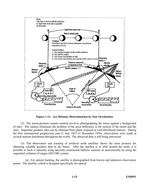
- Page 22 and 23: observation, contains a light sourc
- Page 24 and 25: of a horizontal rod with a small sp
- Page 26 and 27: The Airy theory, announced by G. B.
- Page 28 and 29: Figure 1-15. Products of the Gravim
- Page 30 and 31: a. If the shape of the earth was ex
- Page 32 and 33: Figure 1-16. Single Astronomic Stat
- Page 34 and 35: Figure 1-17. Astro-Geodetic Deflect
- Page 36 and 37: Figure 1-19. Astro-Geodetic Datum O
- Page 38 and 39: (c) The significance of a gravity-o
- Page 40 and 41: absolute deflections of the vertica
- Page 42 and 43: Figure 1-23. Preferred Datumsa. The
- Page 44 and 45: 1-17. The World Geodetic System. Be
- Page 46 and 47: Figure 1-25. Using the Same Referen
- Page 48 and 49: LESSON 1PRACTICE EXERCISEThe follow
- Page 50 and 51: 12. Which of the following is assum
- Page 52 and 53: LESSON 1PRACTICE EXERCISEANSWER KEY
- Page 54 and 55: THIS PAGE IS INTENTIONALLY LEFT BLA
- Page 56 and 57: for all military and civilian activ
- Page 58 and 59: i. Additional support for other top
- Page 60 and 61: 2-7. Status. At present, topographi
- Page 62 and 63: in both. (North American Datum of 1
- Page 64 and 65: water can impede leveling operation
- Page 66 and 67: A field recording booklet. A single
- Page 68 and 69: PART I - OFFICE WORK2-24. General.
- Page 70 and 71:
PART J - SURVEY COMMUNICATION2-28.
- Page 72 and 73:
length or side is known, and all th
- Page 74 and 75:
second-order, Class I net. The leng
- Page 76 and 77:
The number of observations required
- Page 78 and 79:
to perform the reconnaissance. Fail
- Page 80 and 81:
and cultivated, or fields may have
- Page 82 and 83:
e an alphanumeric symbol that is st
- Page 84 and 85:
2-53. Intervisibility of Stations.
- Page 86 and 87:
station is (K/2) 2 x 0.0676, or one
- Page 88 and 89:
Figure 2-8. Similar Triangles Solut
- Page 90 and 91:
2-54. Height of Obstructions. It is
- Page 92 and 93:
authorized to change the name, it s
- Page 94 and 95:
Figure 2-12. Cells Connected in Par
- Page 96 and 97:
added as the cells weaken. Three un
- Page 98 and 99:
Figure 2-16. Construction Details f
- Page 100 and 101:
2-60. Wooden Towers. When it become
- Page 102 and 103:
LESSON 2PRACTICE EXERCISEThe follow
- Page 104 and 105:
11. The face of the 5-inch signal l
- Page 106 and 107:
LESSON 2PRACTICE EXERCISEANSWER KEY
- Page 108 and 109:
average line in a triangulation sys
- Page 110 and 111:
3-4. Slope Measurements. The slope
- Page 112 and 113:
strip as close as possible to its f
- Page 114 and 115:
. Sight along the tops of both of t
- Page 116 and 117:
Column 1. Record the station number
- Page 118 and 119:
stake to steady it. With the back o
- Page 120 and 121:
Figure 3-3. DA Form 4446 (Sample of
- Page 122 and 123:
micrometer in this optical system i
- Page 124 and 125:
laterally across the front of the e
- Page 126 and 127:
Figure 3-7. Horizontal Circle and M
- Page 128 and 129:
out of adjustment. If the index mar
- Page 130 and 131:
(1) In order to avoid instrumental
- Page 132 and 133:
location of the vertical circle on
- Page 134 and 135:
Figure 3-13. Open Traversec. Closed
- Page 136 and 137:
designate the exact point of refere
- Page 138 and 139:
example, a line with an azimuth of
- Page 140 and 141:
When adjusting a traverse that star
- Page 142 and 143:
LESSON 3PRACTICE EXERCISEThe follow
- Page 144 and 145:
11. The unit of graduation on a hor
- Page 146 and 147:
LESSON 3PRACTICE EXERCISEANSWER KEY
- Page 148 and 149:
THIS PAGE IS INTENTIONALLY LEFT BLA
- Page 150 and 151:
differential leveling. The theodoli
- Page 152 and 153:
additional runs are made due to exc
- Page 154 and 155:
Figure 4-2. Wild N-3 Precision Leve
- Page 156 and 157:
(8) Loosen the azimuth clamp (13),
- Page 158 and 159:
4.7. Miscellaneous Equipment. In ad
- Page 160 and 161:
(2) To check for gross errors in th
- Page 162 and 163:
(a) (1) Begin by completing the inf
- Page 164 and 165:
Set up and level the instrument. Re
- Page 166 and 167:
Figure 4-8. Sun and Wind Code(5) Th
- Page 168 and 169:
(10) Enter the interval between the
- Page 170 and 171:
Figure 4-9. Closed-Circuit River Cr
- Page 172 and 173:
Figure 4-11. Sample DA Form 5820 (R
- Page 174 and 175:
is 0. When the telescope is pointed
- Page 176 and 177:
stations. However, since all statio
- Page 178 and 179:
a. Complete the heading, as shown.b
- Page 180 and 181:
a. (1) Enter the date, as in the sa
- Page 182 and 183:
LESSON 4PRACTICE EXERCISEThe follow
- Page 184 and 185:
11. The maximum length of site to o
- Page 186 and 187:
LESSON 4PRACTICE EXERCISEANSWER KEY
- Page 188 and 189:
PART A - GLOBAL POSITIONING SYSTEM
- Page 190 and 191:
5-7. Pseudorange. A pseudorange is
- Page 192 and 193:
5-15. Number of Pseudorange Observa
- Page 194 and 195:
i. Probable Error Measures. The acc
- Page 196 and 197:
Table 5-1. Representative GPS Error
- Page 198 and 199:
Table 5-2. Carrier Phase Trackinga.
- Page 200 and 201:
exercise extreme caution in applyin
- Page 202 and 203:
not be designed or performed to ach
- Page 204 and 205:
Table 5-3. GPS-S Design, Geometry,
- Page 206 and 207:
f. Multiple/Repeat Baseline Connect
- Page 208 and 209:
possible ionospheric and tropospher
- Page 210 and 211:
Figures 5-4. PDOP Versus Time PlotP
- Page 212 and 213:
e. Field Processing and Verificatio
- Page 214 and 215:
All carrier phase relative-surveyin
- Page 216 and 217:
time spent and the cost of conducti
- Page 218 and 219:
movement between occupation sites,
- Page 220 and 221:
5-37. General. GPS baseline solutio
- Page 222 and 223:
(1) Receiver Time. This technique u
- Page 224 and 225:
NOTE: Repeated baselines should be
- Page 226 and 227:
5-43. Loop Closure Checks. Postproc
- Page 228 and 229:
necessary to determine approximate
- Page 230 and 231:
This will ensure that future work w
- Page 232 and 233:
may (and usually does) far exceed t
- Page 234 and 235:
important in evaluating the overall
- Page 236 and 237:
i. Relative GPS baseline standard e
- Page 238 and 239:
LESSON 5PRACTICE EXERCISEThe follow
- Page 240 and 241:
12. When the networking method is s
- Page 242 and 243:
LESSON 5PRACTICE EXERCISEANSWER KEY
- Page 244 and 245:
THIS PAGE IS INTENTIONALLY LEFT BLA
- Page 246 and 247:
FAR-77 obstructions. Aircraft-movem
- Page 248 and 249:
Figure 6-1. Imaginary SurfacesEN059
- Page 250 and 251:
Figure 6-3. Approach Surfacesa. Fed
- Page 252 and 253:
. Federal Aviation Regulation-77, S
- Page 254 and 255:
Table 6-4. Airport Obstruction Accu
- Page 256 and 257:
A horizontal scale of 1:12,000 and
- Page 258 and 259:
Figure 6-4. Sample DA Form 5821 (Ai
- Page 260 and 261:
Figure 6-5. Sample DA Form 5822 (PA
- Page 262 and 263:
LESSON 6PRACTICE EXERCISEThe follow
- Page 264:
LESSON 6PRACTICE EXERCISEANSWER KEY


