- Page 9:
TABLE OF CONTENTSSECTION 1: SYSTEM
- Page 12 and 13:
TABLE OF CONTENTSBlank PageivGarmin
- Page 14:
SECTION 1SYSTEM OVERVIEW1.1 PFD/MFD
- Page 17 and 18:
SECTION 1SYSTEM OVERVIEW1.2 PFD SOF
- Page 19 and 20:
SECTION 1SYSTEM OVERVIEWGPS - Displ
- Page 21 and 22:
SECTION 1SYSTEM OVERVIEWAIRWAYS - P
- Page 23 and 24:
SECTION 1SYSTEM OVERVIEWLarge TextS
- Page 25 and 26:
SECTION 1SYSTEM OVERVIEW2) Apply po
- Page 27 and 28:
SECTION 2FLIGHT INSTRUMENTSSECTION
- Page 29 and 30:
SECTION 2FLIGHT INSTRUMENTS2.1 AIRS
- Page 31 and 32:
SECTION 2FLIGHT INSTRUMENTSMetric D
- Page 33 and 34:
SECTION 2FLIGHT INSTRUMENTS2.5 MARK
- Page 35 and 36:
SECTION 2FLIGHT INSTRUMENTSTurn Rat
- Page 37 and 38:
SECTION 2FLIGHT INSTRUMENTSBearing
- Page 39 and 40:
SECTION 2FLIGHT INSTRUMENTS2.10 GEN
- Page 41 and 42:
SECTION 3 - ENGINEINDICATION SYSTEM
- Page 43 and 44:
SECTION 3 - ENGINEINDICATION SYSTEM
- Page 45 and 46:
SECTION 3 - ENGINEINDICATION SYSTEM
- Page 47 and 48:
SECTION 3 - ENGINEINDICATION SYSTEM
- Page 49 and 50:
SECTION 3 - ENGINEINDICATION SYSTEM
- Page 51 and 52:
SECTION 4 - NAV/COM &TRANSPONDERSEC
- Page 53 and 54:
SECTION 4 - NAV/COM &TRANSPONDER4.1
- Page 55 and 56:
SECTION 4 - NAV/COM &TRANSPONDERAlt
- Page 57 and 58:
SECTION 5 - AUDIO PANELSECTION 5: A
- Page 59 and 60:
SECTION 5 - AUDIO PANEL5.3 NAV RADI
- Page 61 and 62:
SECTION 6 - AUTOMATICFLIGHT CONTROL
- Page 63 and 64:
SECTION 6 - AUTOMATICFLIGHT CONTROL
- Page 65 and 66:
SECTION 6 - AUTOMATICFLIGHT CONTROL
- Page 67 and 68:
SECTION 6 - AUTOMATICFLIGHT CONTROL
- Page 69 and 70:
SECTION 6 - AUTOMATICFLIGHT CONTROL
- Page 71 and 72:
SECTION 6 - AUTOMATICFLIGHT CONTROL
- Page 73 and 74:
SECTION 6 - AUTOMATICFLIGHT CONTROL
- Page 75 and 76:
SECTION 6 - AUTOMATICFLIGHT CONTROL
- Page 77 and 78:
SECTION 6 - AUTOMATICFLIGHT CONTROL
- Page 79 and 80:
SECTION 6 - AUTOMATICFLIGHT CONTROL
- Page 81 and 82:
SECTION 6 - AUTOMATICFLIGHT CONTROL
- Page 83 and 84:
SECTION 6 - AUTOMATICFLIGHT CONTROL
- Page 85 and 86:
SECTION 6 - AUTOMATICFLIGHT CONTROL
- Page 87 and 88:
SECTION 6 - AUTOMATICFLIGHT CONTROL
- Page 89 and 90:
SECTION 6 - AUTOMATICFLIGHT CONTROL
- Page 91 and 92:
SECTION 6 - AUTOMATICFLIGHT CONTROL
- Page 93 and 94:
SECTION 6 - AUTOMATICFLIGHT CONTROL
- Page 95 and 96:
SECTION 6 - AUTOMATICFLIGHT CONTROL
- Page 97 and 98: SECTION 7 - NAVIGATIONSECTION 7: NA
- Page 99 and 100: SECTION 7 - NAVIGATIONFigure 7-5 Re
- Page 101 and 102: SECTION 7 - NAVIGATION4) Turn the l
- Page 103 and 104: SECTION 7 - NAVIGATION4) V4 will no
- Page 105 and 106: SECTION 7 - NAVIGATIONl) V4 is now
- Page 107 and 108: SECTION 7 - NAVIGATION10) At Lamar
- Page 109 and 110: SECTION 7 - NAVIGATIONb) ‘SELECT
- Page 111 and 112: SECTION 7 - NAVIGATIONa) Press the
- Page 113 and 114: SECTION 7 - NAVIGATION19) After pas
- Page 115 and 116: SECTION 7 - NAVIGATION23) After cro
- Page 117 and 118: SECTION 7 - NAVIGATION26) The aircr
- Page 119 and 120: SECTION 7 - NAVIGATIONAccess Runway
- Page 121 and 122: SECTION 7 - NAVIGATION7.8 USER WAYP
- Page 123: SECTION 7 - NAVIGATION7.11 NEAREST
- Page 128 and 129: SECTION 8 - FLIGHT PLANNINGCreate U
- Page 130 and 131: SECTION 8 - FLIGHT PLANNING8.7 CREA
- Page 132 and 133: SECTION 8 - FLIGHT PLANNING8) Turn
- Page 134 and 135: SECTION 8 - FLIGHT PLANNING8.18 DEL
- Page 136 and 137: SECTION 8 - FLIGHT PLANNINGBlank Pa
- Page 138 and 139: SECTION 9 - PROCEDURES9.2 APPROACHE
- Page 140 and 141: SECTION 9 - PROCEDURESBlank Page9-4
- Page 142 and 143: SECTION 10 - HAZARDAVOIDANCEAt a ma
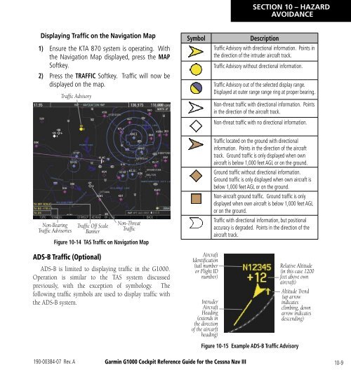
- Page 144 and 145: SECTION 10 - HAZARDAVOIDANCEDisplay
- Page 146 and 147: SECTION 10 - HAZARDAVOIDANCE• Fre
- Page 150 and 151: SECTION 10 - HAZARDAVOIDANCE10.7 TE
- Page 152 and 153: SECTION 10 - HAZARDAVOIDANCE3) Pres
- Page 154 and 155: SECTION 10 - HAZARDAVOIDANCEExcessi
- Page 156 and 157: SECTION 10 - HAZARDAVOIDANCETAWS Al
- Page 158 and 159: SECTION 10 - HAZARDAVOIDANCEBlank P
- Page 160 and 161: SECTION 11 - ABNORMALOPERATION11.2
- Page 162 and 163: SECTION 11 - ABNORMALOPERATIONwill
- Page 164 and 165: SECTION 12 - ANNUNCIATIONS& ALERTS1
- Page 166 and 167: SECTION 12 - ANNUNCIATIONS& ALERTS1
- Page 168 and 169: SECTION 12 - ANNUNCIATIONS& ALERTST
- Page 170 and 171: SECTION 12 - ANNUNCIATIONS& ALERTSS
- Page 172 and 173: SECTION 12 - ANNUNCIATIONS& ALERTSM
- Page 174 and 175: SECTION 12 - ANNUNCIATIONS& ALERTSD
- Page 176 and 177: SECTION 12 - ANNUNCIATIONS& ALERTSG
- Page 178 and 179: SECTION 12 - ANNUNCIATIONS& ALERTSG
- Page 180 and 181: SECTION 12 - ANNUNCIATIONS& ALERTSG
- Page 182 and 183: SECTION 12 - ANNUNCIATIONS& ALERTSG
- Page 184 and 185: SECTION 12 - ANNUNCIATIONS& ALERTSM
- Page 186 and 187: INDEXFLTA 10-13Forward Looking Terr
- Page 188: INDEXWeather product symbol 10-5Wea