navigation acronyms, abbreviations and definitions - International ...
navigation acronyms, abbreviations and definitions - International ...
navigation acronyms, abbreviations and definitions - International ...

Create successful ePaper yourself
Turn your PDF publications into a flip-book with our unique Google optimized e-Paper software.
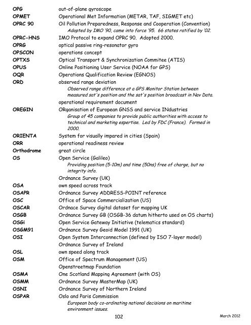
OPG out-of-plane gyroscope<br />
OPMET Operational Met Information (METAR, TAF, SIGMET etc)<br />
OPRC 90 Oil Pollution Preparedness, Response <strong>and</strong> Cooperation (Convention)<br />
Adopted by IMO ‘90, came into force ‘95. 66 states ratified by ‘02.<br />
OPRC-HNS IMO Protocol to exp<strong>and</strong> OPRC 90. Adopted 2000.<br />
OPRG optical passive ring-resonator gyro<br />
OPSCON operations concept<br />
OPTXS Optical Transport & Synchronization Commitee (ATIS)<br />
OPUS Online Positioning User Service (NOAA for GPS)<br />
OQR Operations Qualification Review (EGNOS)<br />
ORD observed range deviation<br />
Observed range difference at a GPS Monitor Station between<br />
measured sat's position <strong>and</strong> the sat's position broadcast in Nav Data.<br />
ORD operational requirement document<br />
OREGIN ORganisation of European GNSS <strong>and</strong> service INdustries<br />
Group of 45 companies to provide public authorities with access to<br />
technical <strong>and</strong> marketing espertise. Led by FDC (France). Formed in<br />
2000.<br />
ORIENTA System for visually impared in cities (Spain)<br />
ORR operational readiness review<br />
Orthodrome great circle<br />
OS Open Service (Galileo)<br />
Providing position (5-10m) <strong>and</strong> time (50ns) free of charge, but no<br />
integrity info.<br />
OS Ordnance Survey (UK)<br />
OSA own speed across track<br />
OSAPR Ordnance Survey ADDRESS-POINT reference<br />
OSC Office of Space Commercialization (US)<br />
OSCAR Ordnace Survey digital dataset for mapping UK<br />
OSGB Ordnance Survey GB (OSGB-36 datum hitherto used on OS charts)<br />
OSGi Open Service Gateway Initiative (telematics st<strong>and</strong>ard)<br />
OSGM91 Ordnance Survey Geoid Model 1991 (UK)<br />
OSI Open System Interconnection (defined by ISO 7-layer model)<br />
OSI Ordnance Survey of Irel<strong>and</strong><br />
OSL own speed along track<br />
OSM Office of Spectrum Management (US)<br />
OSM Openstreetmap Foundation<br />
OSMA One Scotl<strong>and</strong> Mapping Agreement (with OS)<br />
OSMM Ordnance Survey MasterMap (UK)<br />
OSNI Ordnance Survey of Northern Irel<strong>and</strong><br />
OSPAR Oslo <strong>and</strong> Paris Commission<br />
European body co-ordinating national decisions on maritime<br />
environment issues.<br />
102<br />
March 2012