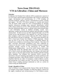
navigation acronyms, abbreviations and definitions - International ...
navigation acronyms, abbreviations and definitions - International ...
navigation acronyms, abbreviations and definitions - International ...

Create successful ePaper yourself
Turn your PDF publications into a flip-book with our unique Google optimized e-Paper software.
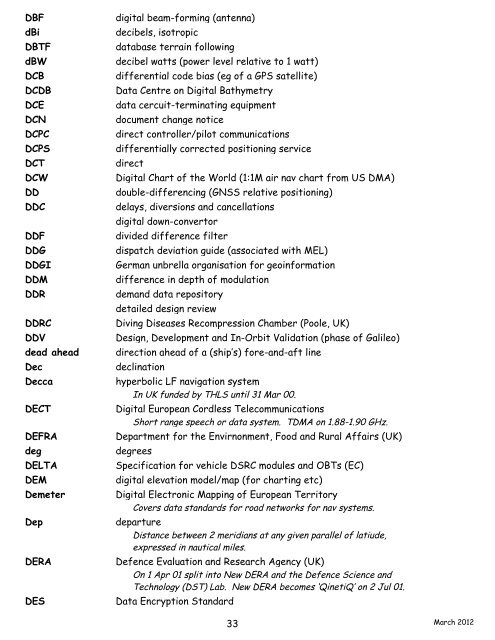
DBF digital beam-forming (antenna)<br />
dBi decibels, isotropic<br />
DBTF database terrain following<br />
dBW decibel watts (power level relative to 1 watt)<br />
DCB differential code bias (eg of a GPS satellite)<br />
DCDB Data Centre on Digital Bathymetry<br />
DCE data cercuit-terminating equipment<br />
DCN document change notice<br />
DCPC direct controller/pilot communications<br />
DCPS differentially corrected positioning service<br />
DCT direct<br />
DCW Digital Chart of the World (1:1M air nav chart from US DMA)<br />
DD double-differencing (GNSS relative positioning)<br />
DDC delays, diversions <strong>and</strong> cancellations<br />
DDC digital down-convertor<br />
DDF divided difference filter<br />
DDG dispatch deviation guide (associated with MEL)<br />
DDGI German unbrella organisation for geoinformation<br />
DDM difference in depth of modulation<br />
DDR dem<strong>and</strong> data repository<br />
DDR detailed design review<br />
DDRC Diving Diseases Recompression Chamber (Poole, UK)<br />
DDV Design, Development <strong>and</strong> In-Orbit Validation (phase of Galileo)<br />
dead ahead direction ahead of a (ship’s) fore-<strong>and</strong>-aft line<br />
Dec declination<br />
Decca hyperbolic LF <strong>navigation</strong> system<br />
In UK funded by THLS until 31 Mar 00.<br />
DECT Digital European Cordless Telecommunications<br />
Short range speech or data system. TDMA on 1.88-1.90 GHz.<br />
DEFRA Department for the Envirnonment, Food <strong>and</strong> Rural Affairs (UK)<br />
deg degrees<br />
DELTA Specification for vehicle DSRC modules <strong>and</strong> OBTs (EC)<br />
DEM digital elevation model/map (for charting etc)<br />
Demeter Digital Electronic Mapping of European Territory<br />
Covers data st<strong>and</strong>ards for road networks for nav systems.<br />
Dep departure<br />
Distance between 2 meridians at any given parallel of latiude,<br />
expressed in nautical miles.<br />
DERA Defence Evaluation <strong>and</strong> Research Agency (UK)<br />
On 1 Apr 01 split into New DERA <strong>and</strong> the Defence Science <strong>and</strong><br />
Technology (DST) Lab. New DERA becomes ‘QinetiQ’ on 2 Jul 01.<br />
DES Data Encryption St<strong>and</strong>ard<br />
33<br />
March 2012