navigation acronyms, abbreviations and definitions - International ...
navigation acronyms, abbreviations and definitions - International ...
navigation acronyms, abbreviations and definitions - International ...

You also want an ePaper? Increase the reach of your titles
YUMPU automatically turns print PDFs into web optimized ePapers that Google loves.
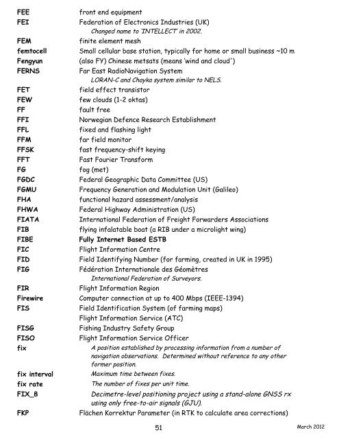
FEE front end equipment<br />
FEI Federation of Electronics Industries (UK)<br />
Changed name to ‘INTELLECT’ in 2002.<br />
FEM finite element mesh<br />
femtocell Small cellular base station, typically for home or small business ~10 m<br />
Fengyun (also FY) Chinese metsats (means ‘wind <strong>and</strong> cloud')<br />
FERNS Far East RadioNavigation System<br />
LORAN-C <strong>and</strong> Chayka system similar to NELS.<br />
FET field effect transistor<br />
FEW few clouds (1-2 oktas)<br />
FF fault free<br />
FFI Norwegian Defence Research Establishment<br />
FFL fixed <strong>and</strong> flashing light<br />
FFM far field monitor<br />
FFSK fast frequency-shift keying<br />
FFT Fast Fourier Transform<br />
FG fog (met)<br />
FGDC Federal Geographic Data Committee (US)<br />
FGMU Frequency Generation <strong>and</strong> Modulation Unit (Galileo)<br />
FHA functional hazard assessment/analysis<br />
FHWA Federal Highway Administration (US)<br />
FIATA <strong>International</strong> Federation of Freight Forwarders Associations<br />
FIB flying infalatable boat (a RIB under a microlight wing)<br />
FIBE Fully Internet Based ESTB<br />
FIC Flight Information Centre<br />
FID Field Identifying Number (for farming, created in UK in 1995)<br />
FIG Fédération <strong>International</strong>e des Géomètres<br />
<strong>International</strong> Federation of Surveyors.<br />
FIR Flight Information Region<br />
Firewire Computer connection at up to 400 Mbps (IEEE-1394)<br />
FIS Field Identification System (of farming maps)<br />
FIS Flight Information Service (ATC)<br />
FISG Fishing Industry Safety Group<br />
FISO Flight Information Service Officer<br />
fix A position established by processing information from a number of<br />
<strong>navigation</strong> observations. Determined without reference to any other<br />
former position.<br />
fix interval Maximum time between fixes.<br />
fix rate The number of fixes per unit time.<br />
FIX_8 Decimetre-level positioning project using a st<strong>and</strong>-alone GNSS rx<br />
using only free-to-air signals (GJU).<br />
FKP Flächen Korrektur Parameter (in RTK to calculate area corrections)<br />
51<br />
March 2012