navigation acronyms, abbreviations and definitions - International ...
navigation acronyms, abbreviations and definitions - International ...
navigation acronyms, abbreviations and definitions - International ...
You also want an ePaper? Increase the reach of your titles
YUMPU automatically turns print PDFs into web optimized ePapers that Google loves.
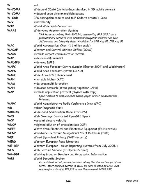
W watt<br />
W-CDMA Wideb<strong>and</strong> CDMA (air interface st<strong>and</strong>ard in 3G mobile comms)<br />
W-CDMA wideb<strong>and</strong> code division multiple access<br />
W-Code GPS encryption code to add to P-Code to create Y-Code<br />
W/V wind velocity<br />
W3C World Wide Web Consortium<br />
WAAS Wide-Area Augmentation System<br />
FAA term describing their GNSS-1, augmenting GPS SPS from a<br />
geostationary satellite with additional <strong>navigation</strong> information plus<br />
differential <strong>and</strong> integrity data. Available for VFR Aug 01, IFR Aug 03<br />
WAC World Aeronautical Chart (1:1 million scale)<br />
WACAF Western <strong>and</strong> Central African Office (ICAO)<br />
WACS wireless airport communication system<br />
WAD wide-area differential<br />
WADGPS wide area DGPS<br />
WAFC World Area Forecast Centre (London [Exeter 2004] <strong>and</strong> Washington)<br />
WAFS World Area Forecast System (ICAO)<br />
WAGE Wide Area GPS Enhancement<br />
WAH when able higher (ATC)<br />
WAM wide-area multi-lateration<br />
WAN wide area network (often joining together LANs)<br />
WAP wireless application protocol (rhymes with ‘zap’)<br />
Specification to enable mobile phone, pager or PDA to access the<br />
Internet.<br />
WARC World Administrative Radio Conference (now WRC)<br />
Wb weber (magnetic flux)<br />
WBMOD Wide-b<strong>and</strong> Scintillation Model (for GPS)<br />
WCS Web Coverage Service (of OpenGIS Spec)<br />
WCV waypoint closure velocity<br />
WDOP weighted dilution of precision (see DOP)<br />
WEEE Waste from Electrical <strong>and</strong> Electronic Equipment (EC Directive)<br />
WEND Worldwide Electronic Navigational Chart Database (IHO)<br />
WEP Wired Equivalent Privacy (WiFi security)<br />
WERD Western European Road Directors<br />
WETREP Western European Tanker Reporting System (from July 2005?)<br />
WFS Web Feature Service (of OpenGIS Spec)<br />
WG-GGI Working Group on Geodesy <strong>and</strong> Geographic Information<br />
WGS World Geodetic System<br />
A consistent set of parameters describing the size <strong>and</strong> shape of the<br />
earth. Most common system is WGS-84 (1984), used by GPS; uses<br />
semi-major axis of 6,378,137 m <strong>and</strong> flattening of 1/298.257.<br />
144<br />
March 2012


