navigation acronyms, abbreviations and definitions - International ...
navigation acronyms, abbreviations and definitions - International ...
navigation acronyms, abbreviations and definitions - International ...

Create successful ePaper yourself
Turn your PDF publications into a flip-book with our unique Google optimized e-Paper software.
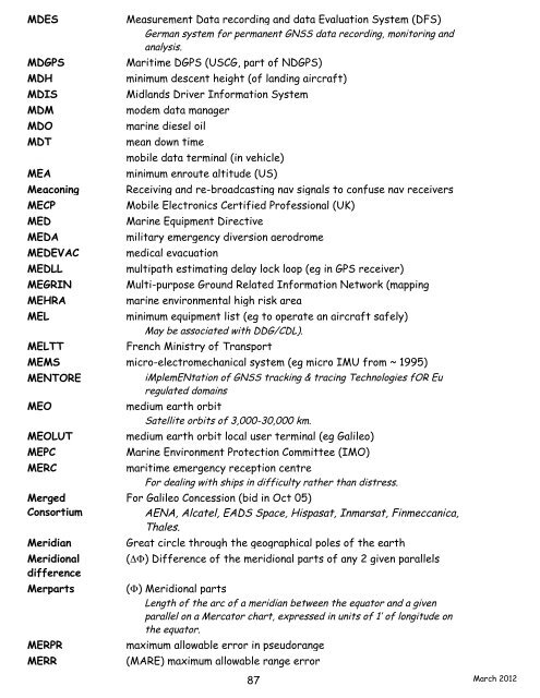
MDES Measurement Data recording <strong>and</strong> data Evaluation System (DFS)<br />
German system for permanent GNSS data recording, monitoring <strong>and</strong><br />
analysis.<br />
MDGPS Maritime DGPS (USCG, part of NDGPS)<br />
MDH minimum descent height (of l<strong>and</strong>ing aircraft)<br />
MDIS Midl<strong>and</strong>s Driver Information System<br />
MDM modem data manager<br />
MDO marine diesel oil<br />
MDT mean down time<br />
MDT mobile data terminal (in vehicle)<br />
MEA minimum enroute altitude (US)<br />
Meaconing Receiving <strong>and</strong> re-broadcasting nav signals to confuse nav receivers<br />
MECP Mobile Electronics Certified Professional (UK)<br />
MED Marine Equipment Directive<br />
MEDA military emergency diversion aerodrome<br />
MEDEVAC medical evacuation<br />
MEDLL multipath estimating delay lock loop (eg in GPS receiver)<br />
MEGRIN Multi-purpose Ground Related Information Network (mapping<br />
MEHRA marine environmental high risk area<br />
MEL minimum equipment list (eg to operate an aircraft safely)<br />
May be associated with DDG/CDL).<br />
MELTT French Ministry of Transport<br />
MEMS micro-electromechanical system (eg micro IMU from ~ 1995)<br />
MENTORE iMplemENtation of GNSS tracking & tracing Technologies fOR Eu<br />
regulated domains<br />
MEO medium earth orbit<br />
Satellite orbits of 3,000-30,000 km.<br />
MEOLUT medium earth orbit local user terminal (eg Galileo)<br />
MEPC Marine Environment Protection Committee (IMO)<br />
MERC maritime emergency reception centre<br />
For dealing with ships in difficulty rather than distress.<br />
Merged<br />
Consortium<br />
For Galileo Concession (bid in Oct 05)<br />
AENA, Alcatel, EADS Space, Hispasat, Inmarsat, Finmeccanica,<br />
Thales.<br />
Meridian Great circle through the geographical poles of the earth<br />
Meridional<br />
difference<br />
(DF) Difference of the meridional parts of any 2 given parallels<br />
Merparts (F) Meridional parts<br />
Length of the arc of a meridian between the equator <strong>and</strong> a given<br />
parallel on a Mercator chart, expressed in units of 1’ of longitude on<br />
the equator.<br />
MERPR maximum allowable error in pseudorange<br />
MERR (MARE) maximum allowable range error<br />
87<br />
March 2012