navigation acronyms, abbreviations and definitions - International ...
navigation acronyms, abbreviations and definitions - International ...
navigation acronyms, abbreviations and definitions - International ...
Create successful ePaper yourself
Turn your PDF publications into a flip-book with our unique Google optimized e-Paper software.
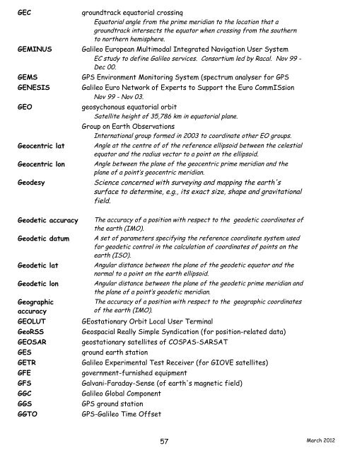
GEC groundtrack equatorial crossing<br />
Equatorial angle from the prime meridian to the location that a<br />
groundtrack intersects the equator when crossing from the southern<br />
to northern hemisphere.<br />
GEMINUS Galileo European Multimodal Integrated Navigation User System<br />
EC study to define Galileo services. Consortium led by Racal. Nov 99 -<br />
Dec 00.<br />
GEMS GPS Environment Monitoring System (spectrum analyser for GPS<br />
GENESIS Galileo Euro Network of Experts to Support the Euro CommISsion<br />
Nov 99 - Nov 03.<br />
GEO geosychonous equatorial orbit<br />
Satellite height of 35,786 km in equatorial plane.<br />
GEO Group on Earth Observations<br />
<strong>International</strong> group formed in 2003 to coordinate other EO groups.<br />
Geocentric lat Angle at the centre of of the reference ellipsoid between the celestial<br />
equator <strong>and</strong> the radius vector to a point on the ellipsoid.<br />
Geocentric lon Angle between the plane of the geocentric prime meridian <strong>and</strong> the<br />
plane of a point’s geocentric meridian.<br />
Geodesy Science concerned with surveying <strong>and</strong> mapping the earth's<br />
surface to determine, e.g., its exact size, shape <strong>and</strong> gravitational<br />
field.<br />
Geodetic accuracy The accuracy of a position with respect to the geodetic coordinates of<br />
the earth (IMO).<br />
Geodetic datum A set of parameters specifying the reference coordinate system used<br />
for geodetic control in the calculation of coordinates of points on the<br />
earth (ISO).<br />
Geodetic lat Angular distance between the plane of the geodetic equator <strong>and</strong> the<br />
normal to a point on the earth ellipsoid.<br />
Geodetic lon Angular distance between the plane of the geodetic prime meridian <strong>and</strong><br />
the plane of a point’s geodetic meridian.<br />
Geographic<br />
accuracy<br />
The accuracy of a position with respect to the geographic coordinates<br />
of the earth (IMO).<br />
GEOLUT GEostationary Orbit Local User Terminal<br />
GeoRSS Geospacial Really Simple Syndication (for position-related data)<br />
GEOSAR geostationary satellites of COSPAS-SARSAT<br />
GES ground earth station<br />
GETR Galileo Experimental Test Receiver (for GIOVE satellites)<br />
GFE government-furnished equipment<br />
GFS Galvani-Faraday-Sense (of earth's magnetic field)<br />
GGC Galileo Global Component<br />
GGS GPS ground station<br />
GGTO GPS-Galileo Time Offset<br />
57<br />
March 2012


