navigation acronyms, abbreviations and definitions - International ...
navigation acronyms, abbreviations and definitions - International ...
navigation acronyms, abbreviations and definitions - International ...

Create successful ePaper yourself
Turn your PDF publications into a flip-book with our unique Google optimized e-Paper software.
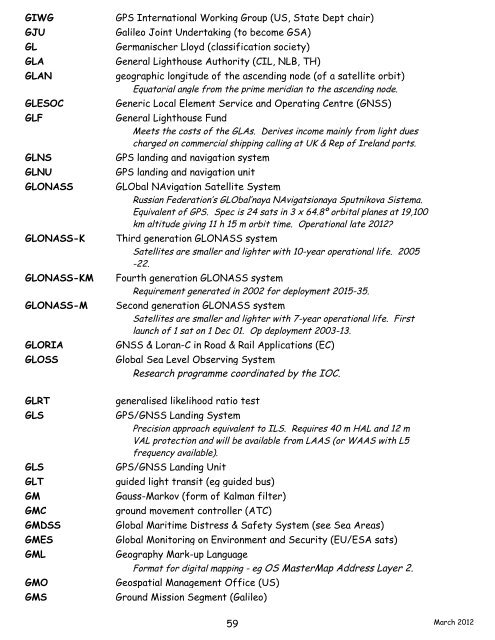
GIWG GPS <strong>International</strong> Working Group (US, State Dept chair)<br />
GJU Galileo Joint Undertaking (to become GSA)<br />
GL Germanischer Lloyd (classification society)<br />
GLA General Lighthouse Authority (CIL, NLB, TH)<br />
GLAN geographic longitude of the ascending node (of a satellite orbit)<br />
Equatorial angle from the prime meridian to the ascending node.<br />
GLESOC Generic Local Element Service <strong>and</strong> Operating Centre (GNSS)<br />
GLF General Lighthouse Fund<br />
Meets the costs of the GLAs. Derives income mainly from light dues<br />
charged on commercial shipping calling at UK & Rep of Irel<strong>and</strong> ports.<br />
GLNS GPS l<strong>and</strong>ing <strong>and</strong> <strong>navigation</strong> system<br />
GLNU GPS l<strong>and</strong>ing <strong>and</strong> <strong>navigation</strong> unit<br />
GLONASS GLObal NAvigation Satellite System<br />
Russian Federation’s GLObal’naya NAvigatsionaya Sputnikova Sistema.<br />
Equivalent of GPS. Spec is 24 sats in 3 x 64.8º orbital planes at 19,100<br />
km altitude giving 11 h 15 m orbit time. Operational late 2012?<br />
GLONASS-K Third generation GLONASS system<br />
Satellites are smaller <strong>and</strong> lighter with 10-year operational life. 2005<br />
-22.<br />
GLONASS-KM Fourth generation GLONASS system<br />
Requirement generated in 2002 for deployment 2015-35.<br />
GLONASS-M Second generation GLONASS system<br />
Satellites are smaller <strong>and</strong> lighter with 7-year operational life. First<br />
launch of 1 sat on 1 Dec 01. Op deployment 2003-13.<br />
GLORIA GNSS & Loran-C in Road & Rail Applications (EC)<br />
GLOSS Global Sea Level Observing System<br />
Research programme coordinated by the IOC.<br />
GLRT generalised likelihood ratio test<br />
GLS GPS/GNSS L<strong>and</strong>ing System<br />
Precision approach equivalent to ILS. Requires 40 m HAL <strong>and</strong> 12 m<br />
VAL protection <strong>and</strong> will be available from LAAS (or WAAS with L5<br />
frequency available).<br />
GLS GPS/GNSS L<strong>and</strong>ing Unit<br />
GLT guided light transit (eg guided bus)<br />
GM Gauss-Markov (form of Kalman filter)<br />
GMC ground movement controller (ATC)<br />
GMDSS Global Maritime Distress & Safety System (see Sea Areas)<br />
GMES Global Monitoring on Environment <strong>and</strong> Security (EU/ESA sats)<br />
GML Geography Mark-up Language<br />
Format for digital mapping - eg OS MasterMap Address Layer 2.<br />
GMO Geospatial Management Office (US)<br />
GMS Ground Mission Segment (Galileo)<br />
59<br />
March 2012