navigation acronyms, abbreviations and definitions - International ...
navigation acronyms, abbreviations and definitions - International ...
navigation acronyms, abbreviations and definitions - International ...

Create successful ePaper yourself
Turn your PDF publications into a flip-book with our unique Google optimized e-Paper software.
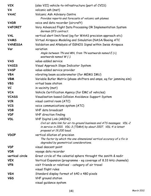
V2X (also V2I) vehicle-to-infrastructure (part of CVIS)<br />
VA volcanic ash (met)<br />
VAAC Volcanic Ash Advisory Centre<br />
Provides reports <strong>and</strong> forecasts of volcanic ash plumes.<br />
VADR voice <strong>and</strong> data recorder (aircraft)<br />
VAFORIT Very Advanced Flight Data Processing OR Implementation System<br />
German DFS contract.<br />
VAL vertical alert limit/level (eg for WAAS precision approach etc)<br />
VAMS Virtual Airspace Modeling <strong>and</strong> Simulation (NASA/Boeing ATC<br />
VANESSA Validation <strong>and</strong> ANalysis of EGNOS Signal within Swiss Airspace<br />
Var variation<br />
Angle between TN <strong>and</strong> MN, from TN eastwards named E (+),<br />
westwards named W (-).<br />
VAS value-added service<br />
VASIS Visual Approach Slope Indicator System<br />
VASP value-added service provider<br />
VBA vibrating beam accelerometer (for MEMS IMU)<br />
VBM Variable Butler Matrix (phase-shifters <strong>and</strong> amps, eg for jamming sim)<br />
VBS virtual base station<br />
VC in vacinity (met)<br />
VCA Vehicle Certification Agency (for EMC of vehicles)<br />
VCASS Visualisation-based Collision Avoidance Support System<br />
VCR visual control room (ATC)<br />
VCS voice communications system (ATC)<br />
VDB VHF data broadcast<br />
VDF VHF direction finding<br />
VDL VHF Digital Link (ARINC)<br />
Civil air data link for air-to-ground business <strong>and</strong> ATS messages. VDL-2<br />
in service in 2001. VDL-3 (TDMA) by about 2007. VDL-4 is latest<br />
proposal at 19,200 baud.<br />
VDOP vertical dilution of precision<br />
The factor by which the one-dimensional vertical accuracy of a fix is<br />
degraded by geometrical considerations.<br />
VDP visual descent point<br />
VDR voyage data recorder<br />
vertical circle Great circle of the celestial sphere throught the zenith & nadir<br />
VEX Vertical Expansion (programme - eg coverage of 8.33 kHz channels)<br />
VFR visit friends or relatives’ - category of air travel<br />
VFR visual flight rules<br />
VGA St<strong>and</strong>ard display format of 640 x 480 pixels<br />
VGS VHF ground station<br />
VGS visual guidance system<br />
141<br />
March 2012