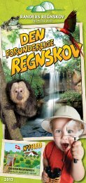
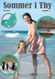
Familiesjov -”Feel Like” natur
Familiesjov -”Feel Like” natur
Familiesjov -”Feel Like” natur

You also want an ePaper? Increase the reach of your titles
YUMPU automatically turns print PDFs into web optimized ePapers that Google loves.
4. Maglehøj<br />
Blandt områdets mange interessante gravhøje skal fremhæves Maglehøj, der er<br />
Odsherreds største. Udsigten fra Maglehøj ses på denne brochures forside. Lidt øst<br />
for Maglehøj ligger Dutterhøje – en gruppe på 5 høje.<br />
I løbet af 2013 etableres en vandresti mellem Maglehøj og Dutterhøje.<br />
GPS E011.30325 N 55.50324<br />
5. Korevlerne<br />
Korevlerne er blot 100 år – formentlig igangsat af en julestorm i 1902. Som en ”knibtangsbevægelse”<br />
er der – fra nord og syd – vokset 2 store sandrevler frem, som<br />
har afsnøret en lagune fra det åbne hav. Lagunen er kun ca. 0,5 m dyb, hvilket gør<br />
området attraktivt for vadefugle. På ydersiden af revlerne er der skabt sandstrand<br />
med marehalm.<br />
Vandrerute (8 km) forbinder Gudmindrup Strand, den nordlige del af Korevlerne og<br />
Ellinge Skov.<br />
GPS E011.31613 N 55.54253<br />
6. Gniben<br />
Spidsen af Sjællands Odde kaldes Gniben, som er den yderste af de i alt 3 øer, der<br />
lå i istidshavet. Aflejringer af grus, sand og sten skabte forbindelse mellem øerne –<br />
dermed dannedes Sjællands Odde. Gniben rummer en militær skydeskole, men en<br />
sti fører hele vejen rundt om Sjællands yderste spids. Yderst ses de såkaldte ”Svømmesten”<br />
– til minde om Kattegat–svømningerne.<br />
Vandrerute (8 km) udgår fra P-plads øst for det militære område.<br />
GPS E011.27684 N 56.01048<br />
7. skansehage<br />
Skansehage er egentlig en sandrevle, som hele tiden vokser ind i fjorden. Navnet<br />
kommer af de skanser, som blev opført i begyndelsen af 1800 til forsvar mod englænderne.<br />
Den hvide bygning, som nu fungerer som feriekoloni, er oprindeligt en<br />
kolera–karantænestation.<br />
Vandrerute (11 km) forbinder Korshage, Skansehage, Rørvig Havn, Højsandet og<br />
Dybesø - tag turen i august, når lyngen blomstrer!<br />
GPS E011.47188 N 55.57247<br />
8. hov vig<br />
Øst for Nykøbing ligger <strong>natur</strong>reservatet Hov Vig, som er et vådområde med et enestående<br />
fugleliv. Området er i virkeligheden et mislykket inddæmningsprojekt, som<br />
påbegyndtes i 1870. Efter dige-gennembrud i 1902 erkendte man, at jordbunden ikke<br />
var særlig frugtbar. I dag er Hov Vig fredet og udlagt som et EU – fuglebeskyttelsesområde.<br />
En cykel – og vandresti fører gennem området, hvor der bl.a. er opført et fugletårn,<br />
hvorfra man kan se skarv – koloni.<br />
GPS E011.70384 N 55.92255<br />
tIPs / tIPPs / tIPs<br />
n (dK) På hver af GeoParkens sites kan I scanne en Qr-kode og se en lille film om det aktuelle sted.<br />
I kan også komme direkte ind på GeoParkens website.<br />
(DE) Auf jeder der GeoPark Sites kann man einen QR-Code scannen und einen kleinen Film über die aktuelle<br />
Stelle sehen. Man kann auch auf die GeoPark Homepage kommen.<br />
(GB) On each of the GeoPark’s sites you can scan a QR-code and watch a small film about the actual site.<br />
You can also enter the GeoPark website.<br />
n (dK) Kort og guide bog til 280 km vandreruter i Odsherred kan købes på turistbureauet.<br />
(DE) Karte und Wanderbuch für 280 km Wanderrouten im Odsherred kann man im touristbüro kaufen.<br />
(GB) You can buy a map and guide book to 280 km of marked footpaths in Odsherred at the tourist Bureau.<br />
(GB) Explore the Ice age landscape<br />
1. vejrhøjbuen<br />
Odsherred’s skeleton consists of three major ranges of<br />
hills – Vejrhøjbuen being the most prominent. the range<br />
stretches from Vindekilde in south-western Odsherred,<br />
north-east along Veddinge Hills and further north around<br />
Asnæs, where it continues towards the shore of the Isefjord.<br />
the area contains several burial mounds, which<br />
our ancestors were partial to building in high places. the<br />
highest point is Vejrhøj itself at 121 m above sea level.<br />
There are several marked footpaths in the area (6 – 11,5<br />
km), e.g. from Dragsholm Castle to Vejrhøj.<br />
2. ægholmen<br />
Ægholmen is an ancient reef from the period where the<br />
Lammefjord contained water.<br />
the reef has been preserved in order for us in the present<br />
to get an idea of what the old fjord bed looked like until the<br />
end of the 19th century.<br />
There is a shelter site at Ægholm Plantation.<br />
3. Esterhøj<br />
You may enjoy impressive views in many places, particularly<br />
from Esterhøj (95 m above sea level) near Høve<br />
where you see Sejerø Bay and Sjællands Odde.<br />
On the summit there is a monument to commemorate the<br />
reunion with Sønderjylland.<br />
Behind Esterhøj you find the burial mound of Ole Olsen,<br />
the founder of Nordisk Film.<br />
There is a good footpath between Esterhøj and Maglehøj.<br />
4. Maglehøj<br />
Among the region’s many interesting burial mounds,<br />
Maglehøj is the most prominent, being Odsherred’s biggest.<br />
the view from Maglehøj is shown on the front page<br />
of this brochure. A little east of Maglehøj you find Dutterhøje,<br />
a group of 5 mounds.<br />
During 2013 a footpath between Maglehøj and Dutterhøje<br />
will be established.<br />
5. Korevlerne<br />
the Korevler land formation is only about 100 years old,<br />
believed to be caused by a Christmas storm in 1902.<br />
Rather like a pincer running from north to south, two<br />
large sand spits have grown, cutting off a lagoon from<br />
the open sea. the lagoon is only about half a metre deep,<br />
which makes it extremely attractive to waders. A sandy<br />
beach with Lyme grass has formed on the outer sides of<br />
the sand spits.<br />
A marked footpath (8 km) connects Gudmindrup Beach,<br />
the northern part of Korevlerne and Ellinge Forest.<br />
6. Gniben<br />
the tip of Sjællands Odde is called Gniben, the outer of<br />
three islands in the Ice Age Sea. Deposits of gravel, sand<br />
and stone connected the islands to form Sjællands Odde.<br />
Gniben is home to a military firing range, but a footpath<br />
does lead all the way round the very tip of Zealand. Engraved<br />
stones mark the spots where the Kattegat Swims<br />
to Jutland started.<br />
A marked footpath (8km) starts at the car park to the east<br />
of the military area.<br />
7. skansehage<br />
Skansehage is actually a sand spit which continues<br />
to grow southwards into the fjord. the name is derived<br />
from “skanser”, redoubts, built in early 19th century as<br />
a defence against the British. the white building, now a<br />
children’s holiday camp, was originally a cholera quarantine<br />
station.<br />
A marked footpath (11 km) connects Korshage, Skansehage,<br />
Rørvig Harbour, Højsandet and Dybesø – take this<br />
walk in August when the heather is in flower.<br />
8. hov vig<br />
East of Nykøbing is Hov Vig <strong>natur</strong>e reserve, a piece of<br />
wetland with an exceptional bird life. the area is actually<br />
a result of a failed land reclaim scheme initiated in 1870,<br />
and after the levee broke in 1902, it was recognized that<br />
the soil was not particularly fertile. today, Hov Vig is a bird<br />
sanctuary and an EU-Protection Area.<br />
A footpath/cycle path leads through the area, where an<br />
observation tower provides an excellent view of many<br />
species of birds, including the cormorant colony.<br />
15