
You also want an ePaper? Increase the reach of your titles
YUMPU automatically turns print PDFs into web optimized ePapers that Google loves.
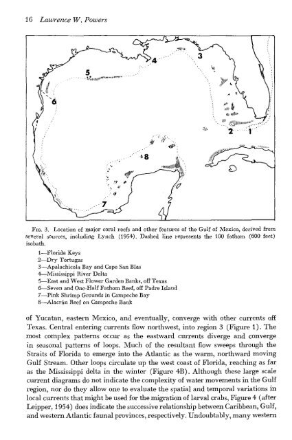
16 Lawrence W. Powers<br />
FIG. 3. Location of major coral reefs and other features of the Gulf of Mexico, derived from<br />
several sources, including Lynch (1954). Dashed line represents the 100 fathom (600 feet)<br />
isobath.<br />
1—Florida Keys<br />
2—Dry Tortugas<br />
3—Apalachicola Bay and Cape San Bias<br />
4—Mississippi River Delta<br />
5—East and West Flower Garden Banks, off Texas<br />
6—Seven and One-Half Fathom Reef, off Padre Island<br />
7—Pink Shrimp Grounds in Campeche Bay<br />
8—Alacran Reef on Campeche Bank<br />
of Yucatan, eastern Mexico, and eventually, converge with other currents off<br />
Texas. Central entering currents flow northwest, into region 3 (Figure 1). The<br />
most complex patterns occur as the eastward currents diverge and converge<br />
in seasonal patterns of loops. Much of the resultant flow sweeps through the<br />
Straits of Florida to emerge into the Atlantic as the warm, northward moving<br />
Gulf Stream. Other loops circulate up the west coast of Florida, reaching as far<br />
as the Mississippi delta in the winter (Figure 4B). Although these large scale<br />
current diagrams do not indicate the complexity of water movements in the Gulf<br />
region, nor do they allow one to evaluate the spatial and temporal variations in<br />
local currents that might be used for the migration of larval crabs, Figure 4 (after<br />
Leipper, 1954) does indicate the successive relationship between Caribbean, Gulf,<br />
and western Atlantic faunal provinces, respectively. Undoubtably, many western