Chapter 1 - Caltrans - State of California
Chapter 1 - Caltrans - State of California
Chapter 1 - Caltrans - State of California

You also want an ePaper? Increase the reach of your titles
YUMPU automatically turns print PDFs into web optimized ePapers that Google loves.
<strong>Chapter</strong> 3 Comments and Coordination<br />
roadway) and further north, the Santa Ynez Mountains in the background. On both sides<br />
<strong>of</strong> the roadway, there are commercial, industrial, agricultural, and residential<br />
developments located on the rolling hillsides.<br />
The overall character <strong>of</strong> this landscape unit can be characterized as more urban than the<br />
southern landscape unit due to greater development along the highway, particularly in the<br />
City <strong>of</strong> Carpinteria. However, existing development does not encroach on the existing<br />
natural viewsheds <strong>of</strong> the landscape unit. The vegetation along the highway obscures the<br />
buildings and structures closest to the highway. Because <strong>of</strong> the urban development and<br />
varied topography <strong>of</strong> this landscape unit, it can be characterized as lacking in continuity,<br />
but having great diversity. Finally, the roadway within this landscape unit is further away<br />
from the Pacific Ocean and <strong>of</strong>fers more distant views <strong>of</strong> natural resources.<br />
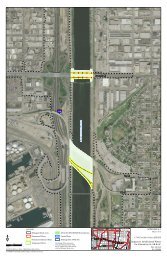
U.S. 101 Southern Portion Landscape Unit<br />
This landscape unit encompasses Ventura County and begins near the Bates Road<br />
Interchange and closely follows the Pacific Ocean coastline until the terminus west <strong>of</strong> the<br />
Mobil Pier Undercrossing. Most views in this landscape unit consist <strong>of</strong> Pacific Ocean<br />
views in the foreground, beaches and roadway in the middleground, and views <strong>of</strong> coastal<br />
bluffs in the background. Much <strong>of</strong> the bluffs contain largely undeveloped coastal scrub<br />
and ranch grasslands, with some agricultural uses. To the southwest <strong>of</strong> the roadway is<br />
the Pacific Ocean with some open space and recreational areas located <strong>of</strong>f the highway<br />
between the ocean and the roadway. Residential communities visible along the highway<br />
include Mussel Shoals, La Conchita, and Rincon Point. Views beyond the coastal bluffs<br />
to the northeast are not visible to viewers on the road or from the residential<br />
communities.<br />
The overall character <strong>of</strong> this landscape unit can be characterized as rural and relatively<br />
undeveloped, with limited residential communities. The natural setting presents open and<br />
dramatic views <strong>of</strong> the coastal bluffs and the ocean that continue throughout the unit.<br />
Drivers on the road are able to view the surrounding natural resources closely,<br />
particularly the coastal cliffs and the ocean since they border the roadway. Additionally,<br />
because the highway follows the coastline so closely, drivers may have the sense <strong>of</strong><br />
traveling along the edge <strong>of</strong> the ocean.<br />
Carpinteria<br />
The City <strong>of</strong> Carpinteria is located in the southeastern corner <strong>of</strong> Santa Barbara County.<br />
The portion <strong>of</strong> Carpinteria adjacent to the proposed project extends from the eastern city<br />
limits to the Casitas Pass Road <strong>of</strong>f-ramp and is more developed than the remainder <strong>of</strong> the<br />
proposed project area.<br />
IS/EA VEN-SB US101 HOV Project 99