Chapter 1 - Caltrans - State of California
Chapter 1 - Caltrans - State of California
Chapter 1 - Caltrans - State of California

You also want an ePaper? Increase the reach of your titles
YUMPU automatically turns print PDFs into web optimized ePapers that Google loves.
<strong>Chapter</strong> 3 Comments and Coordination<br />
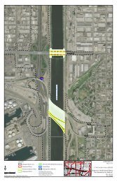
communities <strong>of</strong> Mussel Shoals, La Conchita, and Rincon Point, as well as the southern<br />
area <strong>of</strong> the City <strong>of</strong> Carpinteria.<br />
The Ventura/Santa Barbara 101 HOV Traffic study was used to determine the operational<br />
benefits <strong>of</strong> the proposed improvements during peak traffic volume conditions on the<br />
highway, while also considering the traffic conditions at the interchange intersections.<br />
Furthermore, this study will analyze the impacts to motorists from Mussel Shoals and La<br />
Conchita as a result <strong>of</strong> proposed median closures. To quantify such impact, it is more<br />
appropriate to use peak hour turning movement data for these locations. As such, we<br />
determined that mainline traffic volumes should be based on the peak hours <strong>of</strong> U.S. 101,<br />
and interchange traffic volumes should be based on the peak hours <strong>of</strong> the interchanges.<br />
This approach will result in a conservative data set and ensures that the peak traffic<br />
conditions for the two study components are evaluated accurately.<br />
Forecasted Traffic Volumes<br />
The Department’s policy is to maintain freeway mainline and ramp operations at LOS<br />
based on the Guide for the Preparation <strong>of</strong> Traffic Impact Studies (The Department’s,<br />
December 2002).<br />
The project study area is experiencing an average traffic growth rate <strong>of</strong> 1.05% to 1.30%<br />
annually and long distance commuters are increasing, as affordable housing is located<br />
further away from business and employment centers.<br />
The Santa Barbara County Association <strong>of</strong> Governments (SBCAG) regional travel model<br />
was used to develop annualized growth rates on the U.S. 101 mainline and ramps. Based<br />
on total daily traffic forecasts for Year 2005 and Year 2030, a 1.8 percent annually<br />
compounded growth rate was used to develop traffic forecasts for the Year 2015<br />
(representing the project opening year) and Year 2035. This growth rate was applied to<br />
Year 2008 traffic counts.<br />
Intersections/Ramp Operation<br />
Peak period intersection counts were conducted during the morning (7:00 to 9:00AM)<br />
and evening (4:00 to 6:00PM) at the nine study intersections during a typical weekday<br />
(Tuesday through Thursday) in April 2008. The data includes peak hour intersection<br />
turning movements and cyclist and pedestrian volumes. The count data indicates that the<br />
AM and PM peak hours vary among locations, further justifying the need to use sitespecific<br />
peak hour volumes at the intersections.<br />
During field reconnaissance, lane configurations, turning movement pocket lengths, and<br />
speed limits were collected. The peak hour volumes presented in this report reflect minor<br />
IS/EA VEN-SB US101 HOV Project 65