Chapter 1 - Caltrans - State of California
Chapter 1 - Caltrans - State of California
Chapter 1 - Caltrans - State of California

You also want an ePaper? Increase the reach of your titles
YUMPU automatically turns print PDFs into web optimized ePapers that Google loves.
<strong>Chapter</strong> 3 Comments and Coordination<br />
highway and railroad construction. Little <strong>of</strong> the site is visible on the surface. Past research<br />
in the area has identified six locations, two <strong>of</strong> which are found within the APE Another<br />
location, SBA-1C/D is near the APE, but is situated on a high terrace overlooking the<br />
highway. Numerous burials have been removed over the years, and the site contains a<br />
wide range <strong>of</strong> artifactual and ec<strong>of</strong>actual material including groundstone artifacts, beads,<br />
bifaces, marine shell refuse and faunal remains. It is very unlikely that any intact deposits<br />
exist within the project APE.<br />
CA-SBA-1168<br />
This site was discovered in 1980 during construction monitoring. The site consists <strong>of</strong> a<br />
thin cultural lens located approximately 18 feet below existing grade. The deposit,<br />
containing chipped stone tools and shellfish remains, is covered by imported fill<br />
associated with past highway construction. The deposit is visible in the road cut and is<br />
largely undisturbed in its buried context.<br />
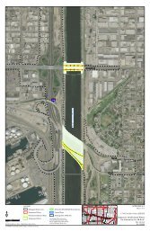
The Area <strong>of</strong> Potential Effects (APE) for the project was established in consultation with<br />
the The Department’s Pr<strong>of</strong>essionally Qualified Staff (PQS) Principal Investigator -<br />
Prehistoric Archaeology, and the VEN/SB 101 HOV Project Manager on April 29, 2008.<br />
The APE was established around the proposed project construction easement. The APE<br />
represents the worst case scenario and includes all proposed alternatives and construction<br />
easements.<br />
Most <strong>of</strong> the project is situated on a marine cut terrace which lies directly below the<br />
southern slope <strong>of</strong> the Santa Ynez Mountains. The terrace dates from the Middle Miocene<br />
and is mainly composed <strong>of</strong> Monterey shale and unnamed sandstone, mudstone, and<br />
breccia (coarse grained rock). Little to no soil development occurs on the terrace. While<br />
coastal sage scrub abounds on the slopes above, only grasses and forbs and other ruderal<br />
species occur on the terrace adjacent to the highway. Most <strong>of</strong> the terrace has been<br />
disturbed by freeway and residential development.<br />
The project is located in the ethnographic and historic territory inhabited by the<br />
Barbareño Chumash <strong>of</strong> the Hokan language stock. The coastal adaptation <strong>of</strong> the Chumash<br />
included subsistence based on shellfish, fish, a variety <strong>of</strong> seeds and vegetable products,<br />
and hunting <strong>of</strong> marine mammals and deer. Groups also traveled inland to trade for piñon<br />
nuts, acorns and elk. The nearby village <strong>of</strong> Shuku located near Rincon Creek was<br />
centrally tied to this exchange network and likely traded with adjacent villages and the<br />
Gabrielino to the south. Modern Chumash place a high value on cultural resources such<br />
as archaeological sites, especially historically identified villages, mortuary areas, and<br />
isolated burials, shrines and traditional natural resources and features.<br />
124 IS/EA VEN-SB US101 HOV Project