Chapter 1 - Caltrans - State of California
Chapter 1 - Caltrans - State of California
Chapter 1 - Caltrans - State of California

Create successful ePaper yourself
Turn your PDF publications into a flip-book with our unique Google optimized e-Paper software.
<strong>Chapter</strong> 2 Affected Environment, Environmental Consequences, and Mitigation Measures<br />
Subsequently, the area was federally classified as a geologic hazard area.<br />
According to the Ventura County Coastal Area Plan, La Conchita is “an older residential<br />
community, about two miles south <strong>of</strong> the Santa Barbara-Ventura County Line, east <strong>of</strong><br />
U.S. Highway 101, that encompasses 19.0 acres and is zoned “R-B” (Residential-Beach)<br />
and “C-C” (Coastal Commercial).” A gas station and convenience store is located at the<br />
corner <strong>of</strong> Surfside Avenue and Santa Barbara Avenue, however, it is not currently<br />
operational. A produce stand is situated on railroad right-<strong>of</strong>-way, near Santa Barbara<br />
Avenue that provides residents and visitors with fresh produce daily. On the plateau <strong>of</strong><br />
Rincon Mountain, sparsely populated agricultural and open space uses are present. To<br />
the northwest <strong>of</strong> La Conchita, avocados are being cultivated. Farther northwest is the<br />
9.8-acre Phillips Petroleum La Conchita Oil and Gas Processing Facility (Tank Farm)<br />
which is no longer active. Agricultural uses and livestock are located immediately<br />
adjacent to La Conchita.<br />
Recreational opportunities within this community are primarily provided by the beach.<br />
While not intended for this purpose, beach users currently utilize a Department<br />
maintained drainage tunnel, located between Oxnard Avenue and Sunland Avenue, for<br />
beach access. The landscaping near the culvert is maintained by the community. In<br />
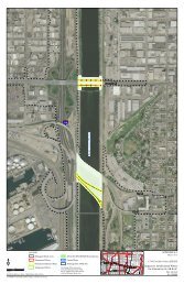
addition, parking is available along Surfside Avenue. Figure 2.1-2 illustrates the land<br />
uses <strong>of</strong> this community and the surrounding area.<br />
Major employment centers are located outside <strong>of</strong> this area, the nearest commercial<br />
services are located in Carpinteria, approximately 4.3 miles north <strong>of</strong> La Conchita, and<br />
accessible only via U.S. 101. These services include neighborhood retail and grocery<br />
services.<br />
Mussel Shoals<br />
The least populated <strong>of</strong> the communities within the study area, Mussel Shoals is composed<br />
<strong>of</strong> mostly larger single-family residences and the Cliff House Inn, a 24-room hotel and<br />
attached restaurant, established in 1923. In 1924, Mussel Shoals was subdivided into 66<br />
lots. In 1956-7, the Richland Oil Company built an island <strong>of</strong>f Mussel Shoals for oil<br />
drilling. According to the Ventura County Coastal Area Plan, Mussel Shoals is “a 5.6-<br />
acre mixed-density residential area. It is located west <strong>of</strong> U.S. Highway 101 and the Old<br />
Coast Highway, and is zoned “R-B” (Residential Beach” and “C-C” (Coastal<br />
Commercial).” The community is connected via two main streets, Old Pacific Coast<br />
Highway and Old Rincon Highway/Breakers Way and Ocean Avenue. A homeowners<br />
association covers the residences along the north side <strong>of</strong> Breakers Way. Rincon Island,<br />
IS/EA VEN-SB US101 HOV Project 24