

State of the Bay Report 2010-Final - Anchor Environmental
State of the Bay Report 2010-Final - Anchor Environmental
State of the Bay Report 2010-Final - Anchor Environmental

Create successful ePaper yourself
Turn your PDF publications into a flip-book with our unique Google optimized e-Paper software.
<strong>Anchor</strong> <strong>Environmental</strong><br />
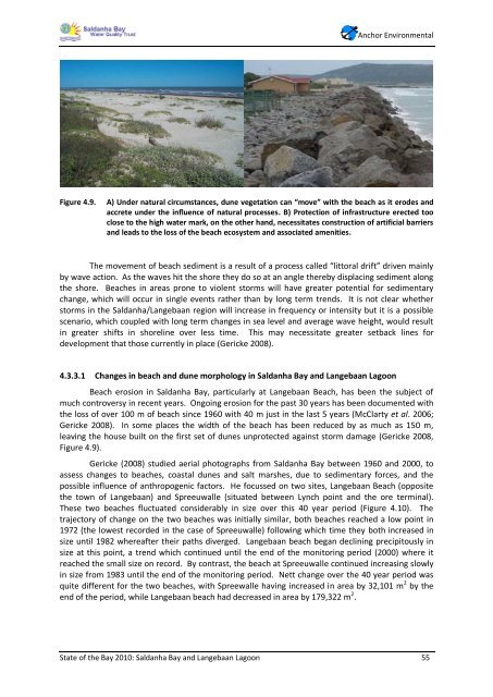
Figure 4.9. A) Under natural circumstances, dune vegetation can “move” with <strong>the</strong> beach as it erodes and<br />
accrete under <strong>the</strong> influence <strong>of</strong> natural processes. B) Protection <strong>of</strong> infrastructure erected too<br />
close to <strong>the</strong> high water mark, on <strong>the</strong> o<strong>the</strong>r hand, necessitates construction <strong>of</strong> artificial barriers<br />
and leads to <strong>the</strong> loss <strong>of</strong> <strong>the</strong> beach ecosystem and associated amenities.<br />
The movement <strong>of</strong> beach sediment is a result <strong>of</strong> a process called “littoral drift” driven mainly<br />
by wave action. As <strong>the</strong> waves hit <strong>the</strong> shore <strong>the</strong>y do so at an angle <strong>the</strong>reby displacing sediment along<br />
<strong>the</strong> shore. Beaches in areas prone to violent storms will have greater potential for sedimentary<br />
change, which will occur in single events ra<strong>the</strong>r than by long term trends. It is not clear whe<strong>the</strong>r<br />
storms in <strong>the</strong> Saldanha/Langebaan region will increase in frequency or intensity but it is a possible<br />
scenario, which coupled with long term changes in sea level and average wave height, would result<br />
in greater shifts in shoreline over less time. This may necessitate greater setback lines for<br />
development that those currently in place (Gericke 2008).<br />
4.3.3.1 Changes in beach and dune morphology in Saldanha <strong>Bay</strong> and Langebaan Lagoon<br />
Beach erosion in Saldanha <strong>Bay</strong>, particularly at Langebaan Beach, has been <strong>the</strong> subject <strong>of</strong><br />
much controversy in recent years. Ongoing erosion for <strong>the</strong> past 30 years has been documented with<br />
<strong>the</strong> loss <strong>of</strong> over 100 m <strong>of</strong> beach since 1960 with 40 m just in <strong>the</strong> last 5 years (McClarty et al. 2006;<br />
Gericke 2008). In some places <strong>the</strong> width <strong>of</strong> <strong>the</strong> beach has been reduced by as much as 150 m,<br />
leaving <strong>the</strong> house built on <strong>the</strong> first set <strong>of</strong> dunes unprotected against storm damage (Gericke 2008,<br />
Figure 4.9).<br />
Gericke (2008) studied aerial photographs from Saldanha <strong>Bay</strong> between 1960 and 2000, to<br />
assess changes to beaches, coastal dunes and salt marshes, due to sedimentary forces, and <strong>the</strong><br />
possible influence <strong>of</strong> anthropogenic factors. He focussed on two sites, Langebaan Beach (opposite<br />
<strong>the</strong> town <strong>of</strong> Langebaan) and Spreeuwalle (situated between Lynch point and <strong>the</strong> ore terminal).<br />
These two beaches fluctuated considerably in size over this 40 year period (Figure 4.10). The<br />
trajectory <strong>of</strong> change on <strong>the</strong> two beaches was initially similar, both beaches reached a low point in<br />
1972 (<strong>the</strong> lowest recorded in <strong>the</strong> case <strong>of</strong> Spreeuwalle) following which time <strong>the</strong>y both increased in<br />
size until 1982 whereafter <strong>the</strong>ir paths diverged. Langebaan beach began declining precipitously in<br />
size at this point, a trend which continued until <strong>the</strong> end <strong>of</strong> <strong>the</strong> monitoring period (2000) where it<br />
reached <strong>the</strong> small size on record. By contrast, <strong>the</strong> beach at Spreeuwalle continued increasing slowly<br />
in size from 1983 until <strong>the</strong> end <strong>of</strong> <strong>the</strong> monitoring period. Nett change over <strong>the</strong> 40 year period was<br />
quite different for <strong>the</strong> two beaches, with Spreewalle having increased in area by 32,101 m 2 by <strong>the</strong><br />
end <strong>of</strong> <strong>the</strong> period, while Langebaan beach had decreased in area by 179,322 m 2 .<br />
<strong>State</strong> <strong>of</strong> <strong>the</strong> <strong>Bay</strong> <strong>2010</strong>: Saldanha <strong>Bay</strong> and Langebaan Lagoon 55


