State Planning Policy 2/07 Guideline - Queensland Mining and Safety
State Planning Policy 2/07 Guideline - Queensland Mining and Safety
State Planning Policy 2/07 Guideline - Queensland Mining and Safety
You also want an ePaper? Increase the reach of your titles
YUMPU automatically turns print PDFs into web optimized ePapers that Google loves.
26<br />
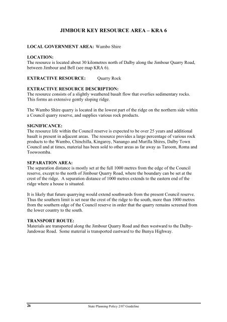
JIMBOUR KEY RESOURCE AREA – KRA 6<br />
LOCAL GOVERNMENT AREA: Wambo Shire<br />
LOCATION:<br />
The resource is located about 30 kilometres north of Dalby along the Jimbour Quarry Road,<br />
between Jimbour <strong>and</strong> Bell (see map KRA 6).<br />
EXTRACTIVE RESOURCE: Quarry Rock<br />
EXTRACTIVE RESOURCE DESCRIPTION:<br />
The resource consists of a slightly weathered basalt flow that overlies sedimentary rocks.<br />
This forms an extensive gently sloping ridge.<br />
The Wambo Shire quarry is located in the lowest part of the ridge on the northern side within<br />
a Council quarry reserve, <strong>and</strong> supplies various rock products.<br />
SIGNIFICANCE:<br />
The resource life within the Council reserve is expected to be over 25 years <strong>and</strong> additional<br />
basalt is present in adjacent areas. The resource provides a large percentage of various rock<br />
products to the Wambo, Chinchilla, Kingaroy, Nanango <strong>and</strong> Murilla Shires, Dalby Town<br />
Council <strong>and</strong> at times, material has been sold to other areas as far away as Taroom, Roma <strong>and</strong><br />
Toowoomba.<br />
SEPARATION AREA:<br />
The separation distance is mostly set at the full 1000 metres from the edge of the Council<br />
reserve, except to the north of Jimbour Quarry Road, where the boundary can be set at the<br />
crest of the ridge. A separation distance of 1000 metres extends to the eastern end of the<br />
ridge where a house is situated.<br />
It is likely that future quarrying would extend southwards from the present Council reserve.<br />
Thus the southern limit is set near the crest of the ridge to the south, more than 1000 metres<br />
from the southern edge of the Council reserve in order that the quarry remains screened from<br />
the lower country to the south.<br />
TRANSPORT ROUTE:<br />
Materials are transported along the Jimbour Quarry Road <strong>and</strong> then westward to the Dalby-<br />
J<strong>and</strong>owae Road. Some material is transported eastward to the Bunya Highway.<br />
<strong>State</strong> <strong>Planning</strong> <strong>Policy</strong> 2/<strong>07</strong> <strong>Guideline</strong>


