State Planning Policy 2/07 Guideline - Queensland Mining and Safety
State Planning Policy 2/07 Guideline - Queensland Mining and Safety
State Planning Policy 2/07 Guideline - Queensland Mining and Safety
You also want an ePaper? Increase the reach of your titles
YUMPU automatically turns print PDFs into web optimized ePapers that Google loves.
30<br />
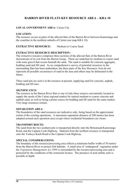
BARRON RIVER FLATS KEY RESOURCE AREA – KRA 10<br />
LOCAL GOVERNMENT AREA: Cairns City<br />
LOCATION:<br />
The resource occurs in parts of the alluvial flats of the Barron River between Kamerunga <strong>and</strong><br />
the coastline in the northern suburbs of Cairns (see map KRA 10).<br />
EXTRACTIVE RESOURCE: Medium to Coarse S<strong>and</strong><br />
EXTRACTIVE RESOURCE DESCRIPTION:<br />
The extractive resource comprises three sections of the alluvial flats of the Barron River<br />
downstream of its exit from the Barron Gorge. These are underlain by medium to coarse s<strong>and</strong><br />
with some gravel that occurs beneath the s<strong>and</strong>. The s<strong>and</strong> is suitable for concrete aggregate,<br />
bedding s<strong>and</strong> <strong>and</strong> fill s<strong>and</strong>. As no comprehensive survey of potential resources in the<br />
surrounding flats has been undertaken, the three parts of the Key Resource Area do not<br />
represent all possible occurrences of s<strong>and</strong> in the area <strong>and</strong> others may be delineated in the<br />
future.<br />
Three s<strong>and</strong> pits are active in the resource at present, supplying s<strong>and</strong> for concrete, asphalt,<br />
bedding <strong>and</strong> fill uses.<br />
SIGNIFICANCE:<br />
The resource in the Barron River flats is one of only three sources conveniently located to<br />
supply the needs of the Cairns regional market for natural medium to coarse concrete <strong>and</strong><br />
asphalt s<strong>and</strong>, as well as being a prime source for bedding <strong>and</strong> fill s<strong>and</strong> for the same market.<br />
Very large resources remain.<br />
SEPARATION AREA:<br />
The boundaries of the s<strong>and</strong> resources are indicative only, being based on the approximate<br />
extent of the existing operations. A maximum separation distance of 200 metres has been<br />
adopted around each operation area except where residential boundaries are closer.<br />
TRANSPORT ROUTE:<br />
The s<strong>and</strong> from the two southern pits is transported directly onto the Brinsmead-Kamerunga<br />
Road, <strong>and</strong> the Captain Cook Highway. Material from the northern resource is transported<br />
onto the Yorkeys Knob Road to the Captain Cook Highway.<br />
SPECIAL CONSIDERATIONS:<br />
The boundary of the resource/processing area reflects a minimum buffer width of 50 metres<br />
from the Barron River to protect fish habitats. A small area of ‘endangered’ vegetation under<br />
the Vegetation Management Act 1999 is surrounded by the resource/processing area <strong>and</strong> is<br />
protected by the conditions of the extraction licence. The presence of acid sulfate soils is<br />
possible at depth.<br />
<strong>State</strong> <strong>Planning</strong> <strong>Policy</strong> 2/<strong>07</strong> <strong>Guideline</strong>


