State Planning Policy 2/07 Guideline - Queensland Mining and Safety
State Planning Policy 2/07 Guideline - Queensland Mining and Safety
State Planning Policy 2/07 Guideline - Queensland Mining and Safety
You also want an ePaper? Increase the reach of your titles
YUMPU automatically turns print PDFs into web optimized ePapers that Google loves.
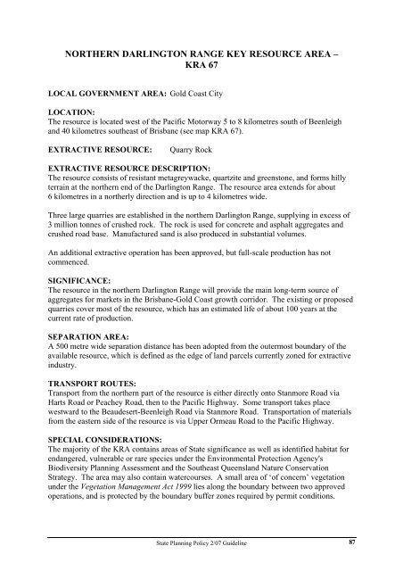
NORTHERN DARLINGTON RANGE KEY RESOURCE AREA –<br />
KRA 67<br />
LOCAL GOVERNMENT AREA: Gold Coast City<br />
LOCATION:<br />
The resource is located west of the Pacific Motorway 5 to 8 kilometres south of Beenleigh<br />
<strong>and</strong> 40 kilometres southeast of Brisbane (see map KRA 67).<br />
EXTRACTIVE RESOURCE: Quarry Rock<br />
EXTRACTIVE RESOURCE DESCRIPTION:<br />
The resource consists of resistant metagreywacke, quartzite <strong>and</strong> greenstone, <strong>and</strong> forms hilly<br />
terrain at the northern end of the Darlington Range. The resource area extends for about<br />
6 kilometres in a northerly direction <strong>and</strong> is up to 4 kilometres wide.<br />
Three large quarries are established in the northern Darlington Range, supplying in excess of<br />
3 million tonnes of crushed rock. The rock is used for concrete <strong>and</strong> asphalt aggregates <strong>and</strong><br />
crushed road base. Manufactured s<strong>and</strong> is also produced in substantial volumes.<br />
An additional extractive operation has been approved, but full-scale production has not<br />
commenced.<br />
SIGNIFICANCE:<br />
The resource in the northern Darlington Range will provide the main long-term source of<br />
aggregates for markets in the Brisbane-Gold Coast growth corridor. The existing or proposed<br />
quarries cover most of the resource, which has an estimated life of about 100 years at the<br />
current rate of production.<br />
SEPARATION AREA:<br />
A 500 metre wide separation distance has been adopted from the outermost boundary of the<br />
available resource, which is defined as the edge of l<strong>and</strong> parcels currently zoned for extractive<br />
industry.<br />
TRANSPORT ROUTES:<br />
Transport from the northern part of the resource is either directly onto Stanmore Road via<br />
Harts Road or Peachey Road, then to the Pacific Highway. Some transport takes place<br />
westward to the Beaudesert-Beenleigh Road via Stanmore Road. Transportation of materials<br />
from the eastern side of the resource is via Upper Ormeau Road to the Pacific Highway.<br />
SPECIAL CONSIDERATIONS:<br />
The majority of the KRA contains areas of <strong>State</strong> significance as well as identified habitat for<br />
endangered, vulnerable or rare species under the Environmental Protection Agency's<br />
Biodiversity <strong>Planning</strong> Assessment <strong>and</strong> the Southeast <strong>Queensl<strong>and</strong></strong> Nature Conservation<br />
Strategy. The area may also contain watercourses. A small area of ‘of concern’ vegetation<br />
under the Vegetation Management Act 1999 lies along the boundary between two approved<br />
operations, <strong>and</strong> is protected by the boundary buffer zones required by permit conditions.<br />
<strong>State</strong> <strong>Planning</strong> <strong>Policy</strong> 2/<strong>07</strong> <strong>Guideline</strong><br />
87


