Aalborg Universitet Bike Infrastructures Report Silva, Victor ... - VBN
Aalborg Universitet Bike Infrastructures Report Silva, Victor ... - VBN
Aalborg Universitet Bike Infrastructures Report Silva, Victor ... - VBN

Create successful ePaper yourself
Turn your PDF publications into a flip-book with our unique Google optimized e-Paper software.
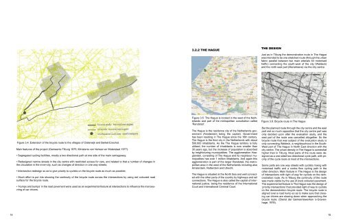
3.2.2 The Hague<br />
The design<br />
Just as in Tilburg the demonstration route in The Hague<br />
was intended to be one stretched route (through the urban<br />
fabric parallel between two main arterials for motorised<br />
traffic) connecting the south-west of the city (Waldeck)<br />
and the north east part (Mariahoeve) via the city centre.<br />
Figure 3.4: Extension of the bicycle route to the villages of Oisterwijk and Berkel-Enschot.<br />
Main features of the project (Gemeente Tilburg 1975; Ministerie van Verkeer en Waterstaat 1977):<br />
• Segregated cycling facilities, mostly a two directional path at one side of the main carriageway;<br />
• Redesigned narrow streets in the city centre with restricted access for cars, and related to that a number of changes in<br />
the circulation in the inner-city, such as changes of direction in one way streets;<br />
• Intersection redesign so as to give priority to cyclists on the bicycle route as much as possible;<br />
• Much effort is put into showing the continuity of the bicycle route across the intersections by using red coloured road<br />
surface for the bicycle route.<br />
• ‘Humps and bumps’ in the road pavement were used as an experimental feature at intersections to influence the manoeuvring<br />
of car drivers.<br />
<br />
Figure 3.5: The Hague is located in the west of the Netherlands<br />
and part of the metropolitan conurbation called<br />
‘Randstad’.<br />
The Hague is the residence city of the Netherlands government<br />
(Amsterdam being the capital). Government<br />
has been residing in The Hague since the 16th century.<br />
The Hague is the third city in the Netherlands with about<br />
500.000 inhabitants. As the The Hague territory is fully<br />
utilised, the number of inhabitants is now smaller than<br />
30 years ago, but the increase of population is absorbed<br />
by neighbouring municipalities. The agglomeration Haaglanden,<br />
consisting of The Hague and its neighbour municipalities<br />
has over 1 million inhabitants. And again this<br />
agglomeration is part of the larger Randstad, the metropolitan<br />
area in the west of the Netherlands including also<br />
Amsterdam, Rotterdam and Utrecht.<br />
The Hague is situated at the North Sea and well connected<br />
with the other parts of the country by highways and rail<br />
connections. The Hague is also called the capital of international<br />
justice, being the residence of the International<br />
Court and International Criminal Court.<br />
Figure 3.6: Bicycle route in The Hague<br />
But the planned route through the city centre and the east<br />
part met so much opposition that the city centre part was<br />
only decided upon after the evaluation study, and the<br />
east part of the route was cancelled altogether. So the<br />
bicycle route that was subject of the evaluation study is<br />
only connecting Waldeck, a neighbourhood in the South-<br />
West part of The Hague in North East direction with the<br />
city centre. The urban density in The Hague is somewhat<br />
higher than in Tilburg. Most parts of the route were designed<br />
as a one sided two directional cycle path, with priority<br />
of the cycle route at most of the intersections.<br />
Some parts are one way streets with cyclists mixing with<br />
motorised traffic and a contra flow cycling path in the<br />
other direction. Main feature in The Hague is the design<br />
of intersections with right of way for cyclists on the demonstration<br />
route. As in Tilburg the continuity of the route<br />
was made visible by the use of (red) coloured pavement.<br />
The experimental feature in The Hague was the design of<br />
‘priority intersections’ that provided right of way to cyclists<br />
on the demonstration bicycle route. The bicycle route is<br />
aligned over a road hump so as to make sure that crossing<br />
car drivers are slowing down when approaching the<br />
bicycle route. (Dienst der Gemeentewerken ’s-Gravenhage,<br />
1978).<br />
14 15