Aalborg Universitet Bike Infrastructures Report Silva, Victor ... - VBN
Aalborg Universitet Bike Infrastructures Report Silva, Victor ... - VBN
Aalborg Universitet Bike Infrastructures Report Silva, Victor ... - VBN

You also want an ePaper? Increase the reach of your titles
YUMPU automatically turns print PDFs into web optimized ePapers that Google loves.
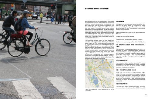
5 Shared space in Haren<br />
Shared space is defined as integrated use of public space<br />
by both motorized and non-motorized modes. It is evolved<br />
out of the ‘woonerf’ concept, which is a residential area<br />
with mixed use of traffic and other activities where cars<br />
have to slow down to a walking pace and so accommodate<br />
other usage of the public space. Shared space is<br />
the opposite of modal segregation. In the Netherlands,<br />
shared space is part of the concept of “duurzaam veilig”<br />
(sustainable safe) that aims to design traffic infrastructure<br />
such that it is inherently safe. Shared space impels drivers<br />
of motorized modes to take full account of the slow<br />
modes. This is assumed to lead to safer and socially responsible<br />
traffic behaviour.<br />
The municipality of Haren, one of the more wealthy municipalities<br />
in the agglomeration of Groningen that is the<br />
largest city in the north of the Netherlands, implemented<br />
and evaluated shared space in the Rijksstraatweg in<br />
2002. The Rijksstraatweg is the main road traversing the<br />
town and used to be the major road connecting Groningen<br />
to the south (“Rijksstraatweg” means national road).<br />
However, since a parallel motorway has been built, the<br />
function of the road is mainly local and to some extent<br />
regional. Still, it is the most heavily used road in Haren.<br />
In 2004 8,200 motor vehicles were counted on a working<br />
day. The road crosses the centre of Haren. Figure 5.1<br />
shows the location of Haren in relation to Groningen. The<br />
Rijksstraatweg is indicated in the figure.<br />
5.1 Design<br />
Starting point for the design was making the road an integral<br />
part of the centre. Before, the typical function of the<br />
road was facilitating through traffic and the road created<br />
severance inside the town. The measures to achieve the<br />
intended integration were:<br />
• Removing differences in height at the transverse section<br />
of the road.<br />
• Making the road optically narrower.<br />
• Installing street furniture that is typical for avenues.<br />
• Reducing the maximum speed from 50 km/h to 30 km/h.<br />
5.2 Organisation and implementation<br />
The municipality encouraged participation of citizens in<br />
developing the project. Experts and citizens together dis<br />
cussed about the new design. During the whole process<br />
from planning to completion interested parties were informed.<br />
This policy created a large support among the<br />
citizens for the project. The implementation of the project<br />
was in 2002.<br />
5.3 Evaluation<br />
A few evaluation studies have been executed. These are<br />
summarized by van der Velde and Bos (2008). Evaluated<br />
topics are use of the road, the impact on safety, and the<br />
experience of users of shared space.<br />
5.3.1 Use of shared space<br />
Initially, cars were assumed to use the main lane in the<br />
middle of the road, pedestrians should use primarily the<br />
cussed about the new design. During the whole process<br />
from planning to completion interested parties were informed.<br />
This policy created a large support among the<br />
citizens for the project. The implementation of the project<br />
was in 2002.<br />
5.3 Evaluation<br />
Figure 5.1: Location of Haren southeast of the city of<br />
Groningen.<br />
A few evaluation studies have been executed. These are<br />
summarized by van der Velde and Bos (2008). Evaluated<br />
58 59