Aalborg Universitet Bike Infrastructures Report Silva, Victor ... - VBN
Aalborg Universitet Bike Infrastructures Report Silva, Victor ... - VBN
Aalborg Universitet Bike Infrastructures Report Silva, Victor ... - VBN

Create successful ePaper yourself
Turn your PDF publications into a flip-book with our unique Google optimized e-Paper software.
In the late 1970s, the medium-sized city of Delft developed<br />
a plan for a coherent bicycle network in the whole<br />
city and requested the central government for a significant<br />
subsidy. The subsidy was granted under the condition<br />
that the implementation would be evaluated elaborately.<br />
The Delft Bicycle Plan was included in the Dutch<br />
second Programme for Person Transport for the period<br />
1980-1984 as an evaluation project (Ministry of Transport<br />
and Public Works, 1986).<br />
The European Economic Community was interested in<br />
the evaluation results and contributed in financing a substantial<br />
part of the costs of the evaluation studies. The<br />
regional authority, the province of South-Holland, played<br />
a minor role in the project. It provided some subsidy for<br />
the implementation. So, four levels of authority were to a<br />
smaller or larger extent involved in the project: local, regional,<br />
national and supranational (Diepens en Okkema,<br />
1994).<br />
4.2 Design<br />
4.2.1 The network<br />
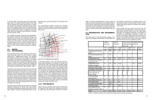
In the Delft Bicycle Plan, three networks on three hierarchical<br />
levels were defined: an urban network, a district<br />
network and a neighbourhood network. The networks<br />
have different functions, service qualities and densities.<br />
All networks have basically a grid-pattern. The existing<br />
infrastructure was basic in the network definition. The objective<br />
of the plan was to upgrade and extend the existing<br />
network in order to achieve a network that satisfies the<br />
requirements of the three defined sub-networks (Ministry<br />
of Transport and Public Works, 1987; Hartman, 1987).<br />
The defined urban network consists of the most important<br />
routes that traverse the entire town and connect to the<br />
regional bicycle system. The function is to accommodate<br />
the larger inter-district bicycle trips as well as the regional<br />
trips that go into or outside the city. It has high standards<br />
for capacity, velocity and convenience. Important barriers<br />
like canals, railways and main roads are crossed at a separate<br />
level. The link spacing is 400-600 m. Frequented facilities<br />
that serve the whole city like railway stations, secondary<br />
schools, and main shopping centres are directly<br />
connected to the network.<br />
The defined district network has two functions. It provides<br />
adequate infrastructure for bicycle trips inside districts<br />
and collects and distributes bicycle traffic to and from the<br />
urban network. The links are spaced 200-300 m. Facilities<br />
like primary schools and shops are connected to the<br />
network.<br />
The neighbourhood network connects the individual<br />
houses to the other networks. It comprises the remaining<br />
streets and shortcuts for the bicycle. The link spacing is<br />
about 100 m.<br />
Figure 4.2: The defined bicycle network<br />
In the before situation, 75% of the defined network already<br />
existed according to the Ministry of Transport and<br />
Public Works (1987). We assume that this figure relates<br />
only to the urban network; for the whole network the figure<br />
is likely to be in the order of 90%. For completion of the<br />
defined network a large number of different projects had<br />
to be executed. Not all defined projects were implemented,<br />
and others were implemented outside the framework<br />
of the bicycle plan. Some projects would only have been<br />
realised if planned new residential quarters had been<br />
developed, a few other expensive projects were subsidised<br />
separately and not considered to be part of the plan<br />
any more (Ten Grotenhuis, 1987). Diepens en Okkema<br />
(1994) assume that some projects were not implemented<br />
because of the high investment costs.<br />
4.2.2 The projects<br />
Plantagebrug<br />
Inner city<br />
Old districts (before<br />
WWII)<br />
Motorway<br />
Railway<br />
Canal<br />
University campus<br />
New districts (after<br />
WWII)<br />
Table 4.1 gives an overview of the numbers of implemented<br />
projects and the length of the infrastructure involved<br />
by project type and sub-network (Diepens en Okkema,<br />
1993). The table demonstrates that a large number of<br />
projects with quite varying natures are executed. Most effort<br />
is made for realising the urban and district networks,<br />
in particular the urban network that is highest in the hierarchy.<br />
The project investments covered the period 1979<br />
to 1991, but most of them were made between 1982 and<br />
1987.<br />
4.3 Organisation and implementation<br />
One of the lessons of the demonstration projects in Tilburg<br />
and The Hague was that good communication with<br />
urban<br />
network<br />
the residents is important for a successful project. In the<br />
Delft case this lesson has been taken to heart. Communication<br />
with interest groups and residents was essential<br />
in the project.<br />
Communication has been done at two levels. First, the<br />
bicycle plan was discussed with a number of general interest<br />
groups, like the Cyclists’ Union, the Traffic Safety<br />
Association, the Pedestrian Association, the Chamber of<br />
Commerce, the Shopkeepers Federation, schools, and<br />
homes for the elderly. These groups could comment on<br />
the plan and suggest adaptations. They had a positive<br />
attitude towards the plan, being bicycle improvements<br />
generally in their favour (ten Grotenhuis, 1987).<br />
district<br />
network<br />
intersections<br />
urban/district<br />
network<br />
neighbourhood<br />
network<br />
# of<br />
proj.<br />
length<br />
(km)<br />
# of<br />
proj.<br />
length<br />
(km)<br />
# of<br />
proj.<br />
length<br />
(km)<br />
# of<br />
proj.<br />
length<br />
(km)<br />
building new bicycle 19 10.5 4 1.3<br />
path<br />
reconstructing bicycle 1 1.8<br />
path<br />
making short cut 4 0.2 10 0.75 2 0.15 1 0.05<br />
defining bicycle lane, 3 1.9 2 1.7<br />
widening road<br />
abolish one way 4 1.8 10 1.55 12 1.65<br />
traffic for bikes<br />
phasing traffic lights 1 0 2 0 4 0<br />
installing traffic lights 3 0 2 0 4 0<br />
permitting cyclists a<br />
free right turn at<br />
traffic lights<br />
1 0 3 0 3 0<br />
reconstructing 6 0 1 0 6 0<br />
intersections<br />
providing crossover 4 0 3 0 1 0<br />
building bridge 3 0.15 4 0.2<br />
reconstructing bridge 1 0.05<br />
building tunnel 1 0.1 1 0.05<br />
providing bicycle 2 0<br />
stands at transit stops<br />
total 53 16.5 42 5.55 19 0.15 14 1.7<br />
Table 4.1: Number of projects and infrastructure length by type of project and network.<br />
30 31