Aalborg Universitet Bike Infrastructures Report Silva, Victor ... - VBN
Aalborg Universitet Bike Infrastructures Report Silva, Victor ... - VBN
Aalborg Universitet Bike Infrastructures Report Silva, Victor ... - VBN

Create successful ePaper yourself
Turn your PDF publications into a flip-book with our unique Google optimized e-Paper software.
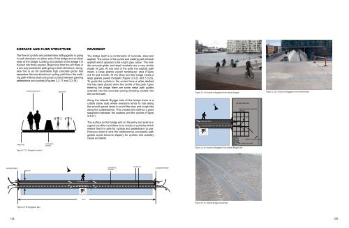
SURFACE AND FLOW STRUCTURE<br />
PAVEMENT<br />
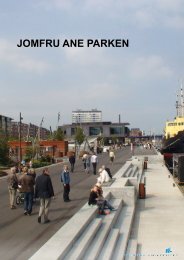
The flow of cyclists and pedestrians at Bryggebro is going<br />
in both directions on either side of the bridge and at either<br />
ends of the bridge. Looking at a section of the bridge it is<br />
divided into three spaces. Beginning from the left there is<br />
a two way pedestrian path going in both directions, alongside<br />
this is an 80 centimetre high concrete girder that<br />
separates the two-directional cycling path from the walking<br />
path without obstructing eye contact between passing<br />
pedestrians and cyclists (Figures 3.3.17 and 3.3.18).<br />
PEDESTRIAN PATH<br />
BIKE PATH<br />
The bridge itself is a combination of concrete, steel and<br />
asphalt. The colour of the cyclist and walking path is black<br />
asphalt which appears to be a light grey colour. The middle<br />
concrete girder and steel handrails are a very similar<br />
shade of grey. At one end of the exits the asphalt path<br />
meets a large granite paved rectangular area (Figure<br />
3.3.19 and 3.3.20). At the other end the bridge meets a<br />
large granite paved footpath (Figure 3.3.22 and 3.3.23).<br />
To guide the cyclists in the correct lane a white dashed<br />
line has been placed down the centre of the path. Upon<br />
entering the bridge there are some metal path guides<br />
screwed into the concrete paving directing cyclists into<br />
the correct path.<br />
Figure 3.3.19: Access to Bryggebro from Islands Brygge.<br />
Figure 3.3.22: Access to Bryggebro from Havenholmen<br />
Along the Islands Brygge side of the bridge there is a<br />
cobble stone road where everyone tends to ride along<br />
the smooth paved lanes to avoid the slow and rough ride<br />
along the cobblestones. This creates and defines a good<br />
separation between the walkers and the cyclists (Figure<br />
3.3.21).<br />
N<br />
ISLANDS BRYGGE<br />
RECTANGULAR GRANITE<br />
AREA<br />
The surface on the bridge and on the entry and exits is in<br />
a good condition and there is no cracks or potholes which<br />
means that it is safe for cyclists and pedestrians to use.<br />
However when it rains the cobblestones and plastic path<br />
guides would become slippery for cyclists and possibly<br />
cause accidents.<br />
WALKNG PATH<br />
CYCLIST PATH<br />
SMOOTH PAVED LINES<br />
HAND RAIL<br />
Figure 3.3.17: Bryggebro section.<br />
CONCRETE<br />
GIRDER<br />
Figure 3.3.20: Access to Bryggebro from Islands Brygge side.<br />
COBBLE STONES<br />
HAVNEHOLMEN<br />
6.5 m<br />
N<br />
CONCRETE<br />
GIRDER<br />
HAND RAIL<br />
ISLANDS BRYGGE<br />
WALKING PATH<br />
CYCLIST PATH<br />
190 m<br />
Figure 3.3.21: Islands Brygge promenade<br />
Figure 3.3.18: Bryggebro plan.<br />
124 125