Aalborg Universitet Bike Infrastructures Report Silva, Victor ... - VBN
Aalborg Universitet Bike Infrastructures Report Silva, Victor ... - VBN
Aalborg Universitet Bike Infrastructures Report Silva, Victor ... - VBN

Create successful ePaper yourself
Turn your PDF publications into a flip-book with our unique Google optimized e-Paper software.
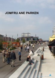
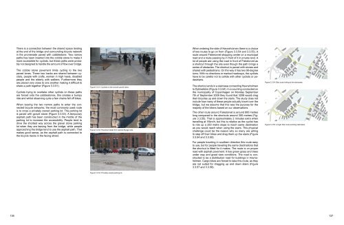
There is a connection between the shared space landing<br />
at the end of the bridge and surrounding bicycle network<br />
in the promenade paved with cobblestone. Two narrow<br />
paths has been inserted into the cobble stone to make it<br />
more accessible for cyclists, but these paths were probably<br />
not designed to handle the amount of flow over bridge.<br />
The cobble stone pavement limits cycling to the two<br />
paved lanes. These two tracks are shared between cyclists,<br />
people with crafts, woman in high heels, disabled<br />
people and the elderly with walkers. Furthermore they<br />
are placed very close to one another making it difficult to<br />
share a path together (Figure 3.3.51).<br />
Cyclists trying to overtake other cyclists on these paths<br />
are forced onto the cobblestones, this creates a bumpy<br />
ride and whilst observing quite a few chains fell off bikes.<br />
When leaving the two narrow paths to enter the connected<br />
bicycle networks, the most commonly used route<br />
is to cross a privately owned parking lot. The parking lot<br />
is paved with gravel stone (Figure 3.3.53). A temporary<br />
asphalt path has been constructed in the middle of the<br />
parking lot to increase the accessibility. People tend to<br />
drive the shortest way across the gravel stone parking<br />
lot when they are leaving from the bridge, while people<br />
approaching the bridge tend to use the asphalt path. That<br />
makes good sense, as the asphalt path is connected to<br />
the bicycle tracks in the facing street.<br />
Figure 3.3.51: Cyclists on the smooth paved lanes.<br />
Figure 3.3.52: Pavement detail fron Islands Brygge side.<br />
When entering the side of Havneholmen there is a choice<br />
of two routes to go on from (Figure 3.3.54 and 3.3.55). A<br />
route around Fisketorvet shopping center on a municipal<br />
road and a route passing by in front of it in private land. A<br />
lot of people are using the road in front of Fisketorvet as<br />
a shortcut through the site even though the path brings a<br />
series of obstacles. The shortcut is paved with stones and<br />
shared with pedestrians. On the way it has two 90-degree<br />
turns. With no directions or marked roadways, the cyclists<br />
have to be careful not to collide with other cyclists or pedestrians.<br />
The shortcut ends in a staircase connecting Havneholmen<br />
to Dybbølsbro (Figure 3.3.54). In a counting conducted on<br />
the municipality of Copenhagen on Monday September<br />
7th of September 2009 they found that 3208 would drag<br />
their bicycles up and down the stairs. The study does not<br />
include how many of these people actually travel over the<br />
bridge, but we assume that this was the purpose for the<br />
majority of the bikers based on our observations.<br />
The other route around Fisketorvet is around 800 metres<br />
long compared to the shortcuts around 300 metres (Figure<br />
3.3.55). That is approximately 2 minutes extra when<br />
travelling at 16km/h, but this is relative as the cyclist has<br />
to ride up a 250 metre slope to reach same destination<br />
as you would reach when using the stairs. This physical<br />
challenge could be the reason why so many are willing<br />
to step off their bikes and drag them up the stairs (Figure<br />
3.3.54 and 3.3.55).<br />
Figure 3.3.54: <strong>Bike</strong> route linking to the staircases.<br />
Figure 3.3.55: Longer bike route avoiding staircases.<br />
For people traveling in southern direction this route easy<br />
to use, but for people traveling the same destinations that<br />
the shortcut is fitted for it makes. The route is on proper<br />
road with asphalt pavement. It has green grass and trees<br />
under way and great view conditions. The road is constructed<br />
to be a distribution road for buildings in Havneholmen.<br />
Cargo bikes are forced to take this route, as they<br />
are not suited for dragging up and down stairs (Figure<br />
3.3.57 and 3.3.58).<br />
Figure 3.3.53: Privately owned parking lot.<br />
136 137