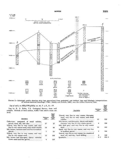
MOWER B201 ALTITUDE. IN FEET 4700- 0 DATUM IS MEAN SEA LEVEL VERTICAL SCALE EXAGGERATED 1 MILE VES 7 o::o- 0 0 (:·:::~:\~. VES 8 A' 4600- 4500- 4400-- --- 4300- EXPLANATION 4200- Clay [;J Gravel Clay and gravel Sand and gravel Quartzite 4100- Sand Clay and sand Clay, sand. and gravel Hardpan or conglomerate Number indicates well mentioned in text or location shown on figure 1 FIGURE 2.-Li.thologi.c profile showing strip logs generalized from geologists' and driHers' logs and lithologic interpretations of vertica1 electrical soundings (VES) (ZO!hdy and Jacl.:son, ·1009), near the Jordan NarrowS!, Utah. Log of well 4- in SEMNWMSEM sec. 23, T. 4- S., R. 1 W. Log by R. D. Feltis, U.S. Geological Survey, from welJ samples. Altitude of land surface, 4,494.7 feet above mean sea level. De&crlption Colluvium; composed of small cobbles, gravel, sand, silt, and clay ______________ _ Gravel, very fine to very coarse; and very fine to very coarse sand; some small cobbles_ Silt, brown; contains sand and fine to medium gravel--------------------------------- Gravel, very fine to very coarse; and very fine to very coarse sand _________________ _ Silt, brown and blue-gray, clayey; contains brown sand and fine graveL _____________ _ Thickness ~ 27 59 7 13 4 Depth btlow land surface (feet) 27 86 93 106 110 Description Gravel, very fine to very coarse; blue-gray sand, very fine to very coarse; and small cobbles ________________________________ Silt, brown, and blue-gray, clayey and sandy; contains very fine to very coarse graveL ___ Silt, dark gray; and very fine to very coarse sand __________________________________ Sand, very fine to very coarse; and very fine to medium graveL ______________________ Gravel, very fine to very coarse; in a matrix of sand, silt, and clay; hard drilling __________ Quartzite ________________________________ Thickness (feet) Depth below land surface (feet) 12 122 4 126 16 142 2 144 6 150 2. 5 152. 5
B202 GROUND-WATER RECHARGE Water is unconfined in the upper part of the aquifer near the Jordan Narrows, and it is poorly confined in the lower part by thin discontinuous beds of silty and sandy clay. The confining beds themselves are moderately permeable, however, and there is appreciable movement of water between the upper and lower parts of ~he aquifer. The ground-water surface (figs. 1 and 2) shows that the water is moving from Utah Valley toward the Jordan Valley. Some of the water is discharged by wells, evapotranspiration, and springs north of the Jordan Narrows, however, before it reaches the main artesian aquifer in the Jordan Valley. The quantity of underflow through the Jordan N arrows was computed at a narrow section of the saturated unconsolidated valley fill. The west end of the section can be located accurately because it abuts an outcrop of semiconsolidated fine-grained material of low average hydraulic conductivity. The location of the east end of the section is less precise because it is marked by the intersection of the water table and semiconsolidated or consolidated material of low hydraulic conductivity, which is concealed beneath the north slope of Point of the Mountain (fig. 1). By correlatio~ of water-level data, data showing depth to material of low hydraulic conductivity in wells, and data from the electrical sounding profile, it was possible to determine a range for the location of the east end of the section. The minimum width of the section so estimated is about 2,700 feet (B-B' in figs. 1 and 3), and the maximum width is about 4,000 feet (B-B" in figs. 1 and 3). ALTITUDE, IN FEET. 4600- 4200- t> D 0 Material of high hydraulic conductivity Material of low hydraulic conductivity· EXPLANATION Zone into which material of high hydraulic conductivity may extend 0 • • 0 0 500 1000 FEET DATUM IS MEAN SEA LEVEL VERTICAL SCALE EXAGGERATED FIGURE 3.-Section along B-B '-B" (fig. 1), showing idealized zones used in computation of underflow from Utah Valley to Jordan Valley near the Jordan Narrows. The thickness of saturated unconsolidated valley fill near the middle of the section across the aquifer is about 125 feet at well 3. If 125 feet is used as·an average . thic~ness for the entire section, therefore, the saturated cross-sectional area (A) is 340,000 square feet for the minimum width of 2,700 feet and 500,000 square feet for the maximum width of 4,000 feet. The average hydraulic gradient (/) of the underflow at the section was determined from water levels in wells 2, 3, and 4· in figures 1 and 2, and is about 0.0002. An aquifer test was made in order to estimate the hydraulic conductivity (K) at the section by pumping well 3 · and observing the amount and rates of waterlevel dra wdown in wells 3 and 4. The hydraulic conductivity was determined from the nonequilibrium equation of the flow of ground water that was developed by Theis ( 1935) and from a. method developed by Theis, Brown, and Meyer (Bentall, 1963, p. 331- 340). The average hydraulic conductivity is high, about 3,200 cubic feet per day per square foot. The Darcy equation, applied to the section of minimum width (B-B'), yields: Q= (3,200 ft per day) (0.0002) (340,000 ft 2 ) =218,000 ft 3 per day, or about 1,800 acre-feet per year. Applied to the section of maximum width ( B-B"), the equation yields: Q = ( 3,200 ft per day) ( 0.0002) ( 500,000 ft 2 ) = 320,000 ft 3 per day, or about 2,700 acre-feet per year. The quantity of underflow through the semiconsolidated and consolidated material bounding the aquifer is small, certainly not exceeding 10 percent of the quantity of underflow in the aquifer. The total underflow from Utah Valley toward Jordan Valley, therefore, is between 2,000 and 3,000 acre-feet per year; and it probably averages about 2,500 acre-feet per year. REFERENCES Bentall, Ray, 1963, Methods of determining permeability, transmissibility, and drawdown: U.S. Geol. Survey Water-Supply Paper 1536--1, p. 243-341. Pitcher, G. G., 1957, Geology of the Jordan Narrows quadrangle, Utah: Brigham Young Univ., Research Studies, Geology Series, v. 4, no. 4, 46 p. Theis, C. V., 1935. The relation between the lowering of the piezometric surface and the· rate and duration of discharge of a well using ground-water storage : Am. Geophys. Union Trans., v. 16, p. 519-524. Zohdy, A. A. R., and Jackson, D. B., 1969, Electrical sounding profile east of the Jordan Narrows, Utah, in Geological Survey Research 1969: U.S. Geol. Survey Prof. Paper 650-C, p. 083-088.
- Page 1 and 2:
. ., GEOLOGICAL SURVEY RESEARCH·
- Page 3 and 4:
CONTENTS GEOLOGIC STUDIES Petrology
- Page 5 and 6:
GEOLOGICAL SURVEY RESEARCH 1970 Geo
- Page 7 and 8:
B2 PETROLOGY AND PETROGRAPHY for bi
- Page 9 and 10:
B4 PETROLOGY AND PETROGRAPHY has be
- Page 11 and 12:
B6 PETROLOGY AND PETROGRAPHY. 32
- Page 13 and 14:
B8 PETROLOGY AND PETROGRAPHY TABLE
- Page 15 and 16:
BlO · PETROLOGY AND PETROGRAPHY EX
- Page 17 and 18:
B12 PETROLOGY AND PETROGRAPHY TABLE
- Page 19 and 20:
GE,OLOGICAL SURVEY RESEA·RCH 1970
- Page 21 and 22:
B16 PETROLOGY AND PETROGRAPHY Sprin
- Page 23 and 24:
B18 PETROLOGY AND PETROGRAPHY TABLE
- Page 25 and 26:
B20 PETROLOGY AND PETROGRAPHY Sigva
- Page 27 and 28:
B22 PETROLOGY AND PETROGRAPHY EXPLA
- Page 29 and 30:
B24 PE~ROLOGY AND PETROGRAPHY schis
- Page 31 and 32:
B26 PETROLOGY AND PETROGRAPHY TABLE
- Page 33 and 34:
B28 PETROLOGY AND PETROGRAPHY sg•
- Page 35 and 36:
B30 PETROLOGY AND PETROGRAPHY Detri
- Page 37 and 38:
B32 PETROLOGY AND PETROGRAPHY place
- Page 39 and 40:
B34 PETROLOGY AND PETROGRAPHY 66 '
- Page 41 and 42:
B36 PETROLOGY AND PETROGRAPHY Post-
- Page 43 and 44:
B38 PETROLOGY AND PETROGRAPHY TABLE
- Page 45 and 46:
B40 PETROLOGY AND PETROGRAPHY did n
- Page 47 and 48:
B42 PETROLOGY AND PETROGRAPHY Creta
- Page 49 and 50:
td :t 106'20' r--- 10' 106'00' 38'3
- Page 51 and 52:
B46 STRUCTURAL GEOLOGY FIGURE 4.-Vi
- Page 53 and 54:
B48 STRUCTURAL GEOLOGY FIGURE 6.-An
- Page 55 and 56:
B50 STRUCTURAL GEOLOGY clined slide
- Page 57 and 58:
GE,OLOGICAL SURVEY RESEARCH 1970 CA
- Page 59 and 60:
B54 GEOPHYSICS (1950), Domzalski (1
- Page 61 and 62:
B56 GEOPHYSICS STRATIGRAPHY AND LIT
- Page 63 and 64:
B58 GEOPHYSICS STRATIGRAPHY AND LIT
- Page 65 and 66:
B60 GEOPHYSICS value. A normal free
- Page 67 and 68:
B62 GEOPHYSICS Hammer, Sigmund, 193
- Page 69 and 70:
B64 110°45' GEOPHYSICS L I I \ "'\
- Page 71 and 72:
GE·OLOGICAL SURVEY RESEA·RCH 1970
- Page 73 and 74:
B68 GEOPHYSICS A' San 0 p A c I F I
- Page 75 and 76:
B70 GEOPHYSICS lies occur over rela
- Page 77 and 78:
B72 GEOPHYSICS 36° 00' A' 40___./
- Page 79 and 80:
B74 GEOPHYSICS igneous massif is co
- Page 81 and 82:
B76 GEOPHYSICS A 50 Bouguer gravity
- Page 83 and 84:
GE·OLOGICAL SURVEY RESEARCH 1970 R
- Page 85 and 86:
B80 GEOPHYSICS FIGURE 1.-Bouguell'
- Page 87 and 88:
B82 GEOPHYSICS J I 37·~~------~~--
- Page 89 and 90:
B84 GEOPHYSICS B 600 B' 500 400 (/)
- Page 91 and 92:
GE,OLOGICAL SURVEY RESEA·RCH 1970
- Page 93 and 94:
EXPLANATION Pikes Peak • batholit
- Page 95 and 96:
DISTRIBUTION OF URANIUM IN URANIUM-
- Page 97 and 98:
B92 GEOCHRONOLOGY Fleischer, R. L.,
- Page 99 and 100:
B94 ECONOMIC GEOLOGY 103° 35' w 1/
- Page 101 and 102:
'B96 ECONOMIC ·GEOLOGY 0 500 FEET
- Page 103 and 104:
B98 ECONOMIC GEOLOGY TABLE !.-Summa
- Page 105 and 106:
BlOO ECONOMIC GEOLOGY surface seems
- Page 107 and 108:
GE 1 0LOGICAL SURVEY RESEA·RCH 197
- Page 109 and 110:
B104 EJrucJh of the four samples wa
- Page 111 and 112:
B106 ECONOMIC GEOLOGY R. 56 E. R. 5
- Page 113 and 114:
B108 ECONOMIC GEOLOGY outcrop under
- Page 115 and 116:
BllO Brady, of the Museum of Northe
- Page 117 and 118:
Bll2 PALEONTOLOGY FIGURE 1.-ProtobZ
- Page 119 and 120:
B114 PALEONTOLOGY c .,;# I I ' ' lO
- Page 121 and 122:
B116 PALEONTOLOGY ments, the larges
- Page 123 and 124:
GErOLOGICAL SURVEY RESEA·RCH 1970
- Page 125 and 126:
B120 L xMH 'xE soo~~B_R~I __ T_I __
- Page 127 and 128:
B122 PALEONTOLOGY Tetrataxis sp. Te
- Page 129 and 130:
GE~OLOGICAL SURVEY RESEARCH 1970 TR
- Page 131 and 132:
Bl26 PALEONTOLOGY TABLE 2.-Ranges o
- Page 133 and 134:
B128 PALEONTOLOGY l
- Page 135 and 136:
BI30 PALEONTOLOGY Ocmt/rrence.-P. m
- Page 137 and 138:
Bl32 PALEONTOLOGY proximately 5.7 m
- Page 139 and 140:
Bl34 PALEONTOLOGY a b c d e f g - D
- Page 141 and 142:
Bl36 PALEONTOLOGY --- 1963. The ori
- Page 143 and 144:
B138 PALEONTOLOGY core are m1ssmg,
- Page 145 and 146:
B140 PALEONTOLOGY death assemblage:
- Page 147 and 148:
Bl42 STRATIGRAPHY EXPLANATION l:.\.
- Page 149 and 150:
B144 STRATIGRAPHY ver. We do not in
- Page 151 and 152:
B146 STRATIGRAPHY age. A stratigrap
- Page 153 and 154:
B148 5 10 15 20 X X Plntygonus Pla.
- Page 155 and 156: GE~OLOGICAL SURVEY RESEARCH 1970 CL
- Page 157 and 158: B152 STRATIGRAPHY at a depth of 58
- Page 159 and 160: ••••• 0 .... ••••
- Page 161 and 162: B156 STRATIGRAPHY REFERENCES Brown,
- Page 163 and 164: B158 STRATIGRAPHY In what follows,
- Page 165 and 166: Bi60 STRATIGRAPHY TABLE !.-Stratigr
- Page 167 and 168: B162 SEDIMENTATION with increasing
- Page 169 and 170: llj ...... ~ TABLE 2.-Specific grav
- Page 171 and 172: B166 TABLE 3.-Settling time for a 1
- Page 173 and 174: Bl68 GEOMORPHOLOGY 74° 44° YERMON
- Page 175 and 176: B170 GEOMORPHOLOGY have also been r
- Page 177 and 178: B172 GEOMORPHOLOGY end of Long Isla
- Page 179 and 180: GEOLOGICAL SURVEY RESEARCH 1970 DET
- Page 181 and 182: ~ooo ______________ B176 ANALYTICAL
- Page 183 and 184: B178 terranes where the search for
- Page 185 and 186: B180 Reproducibility Replicate anal
- Page 187 and 188: B182 ANALYTICAL METHODS in the aque
- Page 189 and 190: GEOLOGICAL SURVEY RESEARCH 1970 CHE
- Page 191 and 192: B186 ANALYTICAL METHODS 3.31 percen
- Page 193 and 194: Bl88 ANALYTICAL METHODS 3" 2%" Oute
- Page 195 and 196: GEOLOGICAL SURVEY RESEA~RCH 1970 TR
- Page 197 and 198: B192 GROUND-WATER RECHARGE I T I 14
- Page 199 and 200: B194 GROUND-WATER RECHARGE Therefor
- Page 201 and 202: GEOLOGICAL SURVEY RESEARCH 1970 PRE
- Page 203 and 204: B198 GROUND-WATER RECHARGE the basi
- Page 205: B200 GROUND-WATER RECHARGE t \ \)
- Page 209 and 210: B204 GROUND-WATER CONTAMINATION rv
- Page 211 and 212: B206 GROUND-WATER CONTAMINATION TAB
- Page 213 and 214: B208. GROUND-WATER CONTAMINATION fa
- Page 215 and 216: GEOLOGICAL SURVEY RESEARCH 1970 MEA
- Page 217 and 218: B212 SURFACE WATER plotted, and the
- Page 219 and 220: GEOLOGICAL SURVEY RESEA·RCH 1970 T
- Page 221 and 222: B216 SURFACE WATER however, if the
- Page 223 and 224: B218 SURFACE WATER TABLE 4.-Variati
- Page 225 and 226: B220 RELATION· BETWEEN GROUND eral
- Page 227 and 228: B222 -0.010 f -0.005 (i) RELATION B
- Page 229 and 230: GEOLOGICAL SURVEY RESEARCH 1970 THE
- Page 231 and 232: 'B226 RELATION BETWEEN GROUND WATER
- Page 233 and 234: B228 RELATION, BETWEEN GROUND WATER
- Page 235 and 236: B230 RELATION BETWEEN GROUND WATER
- Page 237 and 238: GEOLOGICAL SURVEY RESEARCH 1970 HYD
- Page 239 and 240: B234 EROSION AND SEDIMENTATION side
- Page 241 and 242: B236 EROSION AND SEDIMENTATION s·o
- Page 243 and 244: B238 EROSION AND SEDIMENTATION Cont
- Page 245 and 246: B240 EROSION AND SEDIMENTATION 2 3
- Page 247 and 248: GEOLOGICAL SURVEY RESEARCH 1970 SPE
- Page 249 and 250: B244 GEOCHEMISTRY OF WATER REFERENC
- Page 251 and 252: B246 HYDROLOGIC TECHNIQUES The upla
- Page 253 and 254: B248 HYDROLOGIC TECHNIQUES type in
- Page 255 and 256: GEOLOGICAL SURVEY RESEARCH 1970 ,,.
- Page 257 and 258:
B252 formula may also be useful in
- Page 259 and 260:
GEO'LOGICAL SURVEY RESEARCH 1970 CO
- Page 261 and 262:
B256 randomly fluctuating component
- Page 263 and 264:
B258 HYDROLOGIC TECHNIQUES 1.0 ~ Qj
- Page 265 and 266:
~ B260 HYDROLOGIC TECHNIQUES 1-3, f
- Page 267 and 268:
I B262 HYDROLOGIC TECHNIQUES REFERE
- Page 269 and 270:
,' B264 Page Gravitational sliding,
- Page 271 and 272:
., / )