

RESEARCH· ·1970·
RESEARCH· ·1970·
RESEARCH· ·1970·

Create successful ePaper yourself
Turn your PDF publications into a flip-book with our unique Google optimized e-Paper software.
B248<br />
HYDROLOGIC TECHNIQUES<br />
type in the upper area. Another 20 percent of the watershed<br />
has a silty-clay soil derived from Cody Shale.<br />
Roots penetrate this soil about 1 foot. This area is<br />
covered with Nuttall saltbrush and bottlebrush squirreltail<br />
(Sitanion hystrix). The remaining 10 percent of<br />
the watershed is comprised of high, grass-covered<br />
plateaus and of bottomlands covered with greasewood<br />
(Sarcobatus vermiculat1ts). Average annual precipitation<br />
is estimated to be about 10 inches (N.J. King, oral<br />
commun., 1969). · Runoff occurs from snowmelt and<br />
rains in the spring, and from occasional torrential summer<br />
storms (Peterson, 1961). Additional hydrologic<br />
information, including a 16 ... year record of sediment<br />
yield through July 1968, was obtained from King<br />
(1959) and from N.J. King and G. C. Lusby (written<br />
commun., 1969).<br />
RE,SULTS AND DISCUSSION<br />
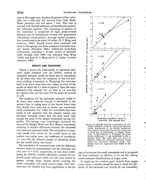
Figure 2 shows the relationship of estimated sediment<br />
yields obtained with the PSIAC method to<br />
measured sediment yields for three sets of watersheds.<br />
In all three sets, with the exception of the low-sediment-yielding<br />
watersheds in Wyoming, the estimates<br />
tend to be lower than reservoir values, as most of the<br />
points lie above the 1 :1 lines in figure 2. Also, the mean<br />
sediment-yield estimate for all sites is 1.4 acre-feet<br />
per square mile, and the mean for the reservoir records<br />
is 1.73.<br />
The tendency for the estimated sediment yields to<br />
be lower ·than reservoir records is attributed to the<br />
author's bias in rating some of the factors lower than<br />
they should have been, but no factor was consciously<br />
rated consistently low. After the watersheds had been<br />
rated, it was apparent that the channel erosion and<br />
sediment transport factor had not been rated high<br />
enough for some of the steeper watersheds having raw<br />
gullies. The ratings were accordingly increased for<br />
some of the Badger Wash and New Mexico watersheds,<br />
resulting in smaller differences between the estimated<br />
and measured sediment yields. The correlation of measured<br />
runoff with values for the runoff factor in the<br />
method was rather poor; the coefficient of correlation<br />
(1·) was 0.34. No objective means of adjusting values<br />
for the runoff factor was found.<br />
The correlation of watershed area with the difference<br />
between reservoir measurements and the estimates was<br />
very poor ( r = 0.13). Apparently, on very small watersheds,<br />
the PSIAC method sufficiently accounts for expected<br />
larger sediment yields per unit area caused by<br />
greater average slope, intense storms covering the<br />
whole watershed, and small transit losses. This indicates<br />
that the method may have application in the de-<br />
UJ<br />
...J<br />
i<br />
UJ<br />
0::<br />
c(<br />
:::::><br />
0<br />
(/)<br />
0::<br />
UJ<br />
a..<br />
1-<br />
UJ<br />
UJ<br />
LL.<br />
w<br />
0::<br />
u<br />
c(<br />
~<br />
Q<br />
...J<br />
UJ<br />
>=<br />
1-<br />
z<br />
UJ<br />
::::ii:<br />
0<br />
UJ<br />
(/)<br />
0<br />
UJ<br />
0::<br />
:::::><br />
(/)<br />
c(<br />
UJ<br />
~<br />
5<br />
4<br />
3<br />
2<br />
0<br />
5<br />
4<br />
3<br />
2<br />
0<br />
5<br />
4<br />
3<br />
2<br />
r=0.94·<br />
r =0.96<br />
'=0.74<br />
/<br />
//<br />
.,."'<br />
/<br />
,. .... ,.,."'<br />
ESTIMATED SEDIMENT YIELD, IN<br />
ACRE-FEET PER SQUARE MILE<br />
;-<<br />
FIGURE 2.-Graphs showing reLationship of estimated<br />
sediment yields to measured sediment<br />
yi,elds, determined by the Pacific Southwest<br />
Inter-Agency Committee method, for reservoirs<br />
in three sets of watersheds: A, Badger Wash,<br />
Colo.; B, New Mexico; C, Wyoming. All correlation<br />
coefficients ( 1·) are significant at the 1-<br />
percent level. The solid lines are lines of<br />
equality where the estimated sediment yields<br />
equal the measured sediment yields. The<br />
dashed lines are regression lines fitted to the<br />
points.<br />
sign of structures for small watersheds and in proposals<br />
for land treatment, in addition to its use for 1naking<br />
broad sediment classifications of larger areas.<br />
In applying this method, good records from gaged<br />
areas, where available, should be used to check the estimates.<br />
If the estimates and records do not reasonably<br />
.)<br />
0<br />
-~<br />
"t


