

RESEARCH· ·1970·
RESEARCH· ·1970·
RESEARCH· ·1970·

You also want an ePaper? Increase the reach of your titles
YUMPU automatically turns print PDFs into web optimized ePapers that Google loves.
GEOLOGICAL SURVEY RESEARCH 1970<br />
\.<br />
EVALUATION OF A METHOD FOR ESTIMATING SEDIMENT YIELD<br />
By LYNN M. SHOWN, Denver, Colo.<br />
•,.<br />
A.1J8t?·a.ct.-A method for estimating annual sediment yield,<br />
developed by the Pacific Southwest Inter-Agency Committee,<br />
wus tested iu 28 small watersheds ranging in size from 0.02 to<br />
37 squn re miles. These watersheds for which hydrologic records<br />
exist nre in nricl nnd seminrid arens of western Colorado,<br />
north-centrnl New Mexico, nnd east-centrnl 'Vyoming, and<br />
represent a vnriety of geologic, climntic, ecologic, and topogt·nphic<br />
conditions. Estimates of sediment yield correlated<br />
closely with sediment yields mensured in reservoirs, but the<br />
estimutes were usunlly lower than the measured yields. The<br />
method wns designed to mnl(e general sediment classifications<br />
for nrens gt·eater than 10 square miles, but it also appears to<br />
work nearly ns well for watersheds that are as small as 0.1<br />
square mile.<br />
Sediment-yield records for drainage areas of less<br />
than 500 square miles in wildland areas of the '¥estern<br />
United States are scarce. :Managers of land in these<br />
areas need estimates of sediment yield to aid in decisions<br />
which concurrently affect water, soil, timber,<br />
forage, and recreation. A sedimentation task force of<br />
the Pacific Southwest Inter-Agency Committee (PSI<br />
AC) prepared n, guideline method for field evaluation<br />
of sediment yields, in conjunction with a discussion of<br />
factors affecting sediment yields in the Pacific Southwest<br />
area.<br />
The purpose of this investigation was to determine<br />
the usefulness of the PSIAC method for extrapolating<br />
sediment-yield information to areas lacking records.<br />
METHOD<br />
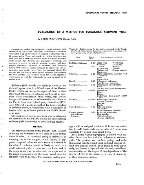
The 1nethod developed by the PSIAC (1968) consists<br />
of rating the watershed on the basis of nine factors<br />
shown in table 1. A numerical rating is arrived at by<br />
summing the values assigned to the factors. A suggested<br />
range of values for each factor is included in<br />
the table. If a factor would be likely to result in a<br />
small sediment yield, n, value near the lower end of<br />
the range is assigned. A value near the upper end of<br />
the range is assigned when the factor would cause the<br />
sediment yield to be large. For exmnple, surface geol-<br />
TABLE 1..-Rating ranges for the factors evaluated in the Pacific<br />
Southwest Inter-Agency Committee method for estimating sediment<br />
yields using terrain characteristics<br />
Factor<br />
Rating<br />
range<br />
Surface geology____ 0-10<br />
Soils _____________ 0-10<br />
Climate__________ 0-10<br />
Itunoff___________ 0-10<br />
Topography_______ 0-20<br />
Ground cover_____ -1Q-10<br />
Land use _________ -10-10<br />
Upland erosion____ 0-25<br />
Channel erosion 0-25<br />
and sediment<br />
transport.<br />
Main characteristics considered<br />
Rock type.<br />
Hardness.<br />
Texture.<br />
Aggregation.<br />
Shrink-swell.<br />
Rockiness.<br />
Weathering.<br />
Fracturing.<br />
Salinity.<br />
Caliche.<br />
Organic matter.<br />
Storm frequency, intensity, and<br />
duration.<br />
Snow.<br />
Freeze-thaw.<br />
V clume per unit area.<br />
Peak flow per unit area.<br />
Steepness of upland slopes.<br />
Relief.<br />
Fan and flood plain development.<br />
Vegetation.<br />
Litter.<br />
Itocks.<br />
Understory development under<br />
trees.<br />
Percentage cultivated.<br />
Grazing intensity.<br />
Logging.<br />
Ito ads.<br />
Rills and gullies.<br />
Landslides.<br />
Wind deposits in channels.<br />
Bank and bed erosion.<br />
Flow depths.<br />
Active headcuts.<br />
Channel vegetation.<br />
ogy would be assigned a value of 10 in an area underlain<br />
by soft fissile shale, and a value of 1 in an area<br />
underlain by several thick basalt flows.<br />
Each factor except topography is paired with another<br />
factor that has a similar influence on sediment<br />
yield. The pairings are : surface geology and soils,<br />
climate and runoff, ground cover and land use, and upland<br />
and channel erosion. Each factor is rated separately,<br />
but the one it is paired with is usually considered<br />
concurrently, and the degree of interdependence of the<br />
two is reflected in the similarity or lack of similarity<br />
in their respective ratings.<br />
U.S. GEOL. SURVEY PROF. PAPER 700-B, PAGES B245-B249<br />
B245


