

RESEARCH· ·1970·
RESEARCH· ·1970·
RESEARCH· ·1970·

Create successful ePaper yourself
Turn your PDF publications into a flip-book with our unique Google optimized e-Paper software.
SWENSON<br />
B211<br />
lakes in various degrees of filling along many of our<br />
streams tends to indicate that lateral shifts of channel<br />
and migration of meanders are exceedingly common.<br />
"\Volman and Leopold (1957) present a table compiling<br />
data on lateral migration of rivers across valleys.<br />
Smne of the data on which this .table is based are admittedly<br />
crude, but the wide range in rates of lateral<br />
1novement is of interest. Some of the streams show no<br />
appreciable movement in periods of up to 50 or 60<br />
years; others are believed to have shifted laterally<br />
hundreds of feet a year over long periods.<br />
It would appear that the Arkansas River in eastern<br />
Colorado, with its flood plain developed on erodible,<br />
unconsolidated material, could be expected to have appreciable<br />
lateral shifts and downstream migration of<br />
meanders. The fact that it carries a moderate load of<br />
sand and smaller sized material, and ranges widely in<br />
discharge, would serve to increase meandering of the<br />
stream. The presence of meander scallops on the edges<br />
of the terraces bordering the flood plain and more or<br />
less filled oxbow lakes tends also to confirm such movement<br />
in the past.<br />
R. 54 W.<br />
PAST COURSES OF THE ARKANSAS RIVER NEAR<br />
BENT'S O.LD FORT<br />
Early descriptions state that the Arkansas River was<br />
about 300 yards fron1 the fort between 1833 and 1849,<br />
but they do not say if it was this close on the south or<br />
east. The location of the ford on the Santa Fe Trail<br />
indicates that the river ran east of the fort. No rna ps<br />
or charts showing the relative position of the fort and<br />
the Arkansas River are known.<br />
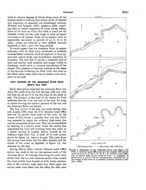
The first survey of the area was made during July<br />
and August 1869, when the U.S. General Land Office<br />
laid out the section lines south of the river. In the<br />
course of this survey a meander line was run which<br />
was intended to depict the ordinary high-water line<br />
and the sinuosities of the river. This was accomplished<br />
by starting at a known point where the section line<br />
intersected the river and chaining from this point on<br />
a stated bearing to another station located on the<br />
ordinary high-water line. A total of 14 such points,<br />
shown on figure 1A, w.ere so located. The notes from<br />
this survey were taken into the office, plotted, and the<br />
course of the river, as depicted in figure 1A, was<br />
sketched on the plat.<br />
During March 1882 a similar General Land Office ·<br />
survey was made to lay out the sections north of the<br />
Arkansas River. No meander line along the north bank<br />
of the river was run, but wherever section lines crossed<br />
the river, points were located on both banks, presumably<br />
at the ordinary high-water line. Here again the<br />
survey notes were taken into the offic~~ th~ data were<br />
x 1869 meander point<br />
EXPLANATION<br />
o 1882 ordinary high water point<br />
FIGURE 1.-Meanders of the Arkansas River near Bent's Old<br />
Fort. A, General Land Office plat of July-August 1869 survey<br />
south of river in T. 23 S., R. 54 W.; B, General Land Office<br />
plat of March 1882 survey north of river; 0, composite of<br />
points from A and B with an interpretation (sketched in) of<br />
the course of the river as it probably actually existed at that<br />
time ( 1869).<br />
+


