

RESEARCH· ·1970·
RESEARCH· ·1970·
RESEARCH· ·1970·

You also want an ePaper? Increase the reach of your titles
YUMPU automatically turns print PDFs into web optimized ePapers that Google loves.
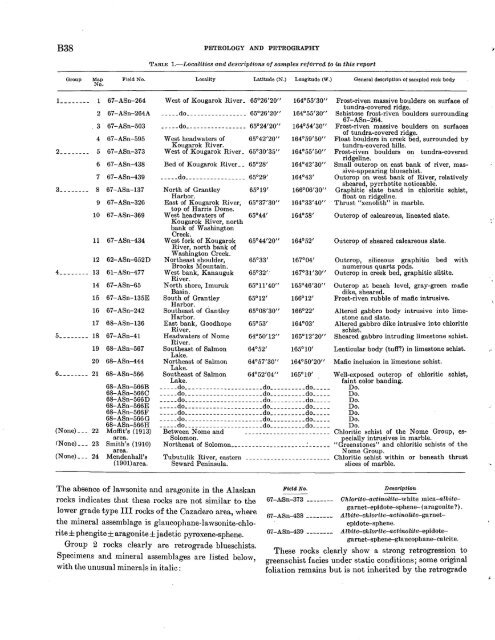
B38<br />
PETROLOGY AND PETROGRAPHY<br />
TABLE 1.-Localities and descriptions of samples referred to in this report<br />
Group<br />
Map<br />
No ..<br />
Field No.<br />
Locality Latitude (N .) Longitude (W .)<br />
General description of sampled rock body<br />
L _ _ _ __ __ 1 67-ASn-264<br />
2 67-ASn-264A<br />
3 67-ASn-503<br />
4 67-ASn-595<br />
2 ________ 5 67-ASn-373<br />
6 67-ASn-438<br />
7 67-ASn-439<br />
3________ 8 67-ASn-137<br />
9 67-ASn-326<br />
10 67-ASn-369<br />
11 67-ASn-434<br />
12 62-ASn-652D<br />
4 ________ 13 61-ASn-477<br />
14 67-ASn-65<br />
15 67-ASn-135E<br />
16 67-ASn-242<br />
17 68-ASn-136<br />
5 ________ 18 67-ASn-41<br />
19 68-ASn-567<br />
20 68-ASn-444<br />
6 ____ ---- 21 68-ASn-566<br />
68-ASn-566B<br />
68-ASn-566C<br />
68-ASn-566D<br />
68-ASn-566E<br />
68-ASn-566F<br />
68-ASn-566 G<br />
68-ASn-566H<br />
(None) ___ 22 Moffit's (1913)<br />
area.<br />
fNone) ___ 23 Smith's (1910)<br />
area.<br />
(None)___ 24 Mendenhall's<br />
(1901)area.<br />
West of Kougarok River_ 65°26'20"<br />
_____ do _________________ 65°26'20"<br />
_____ do _________________ 65°24'20"<br />
164°55'30"<br />
164°55'30"<br />
164°54'30"<br />
West headwaters of 65°42'20" 164°59'50"<br />
Kougarok River.<br />
West of Kougarok River_ 65°30'35" 164°55'50"<br />
Bed of Kougarok River__ 65°28'<br />
_____ do _________________ 65°29'<br />
164°42'30"<br />
164°43'<br />
North of Grantley 65°19' 166°06'30"<br />
Harbor.<br />
East of Kougarok River, 65°37'30" 164°33' 40"<br />
top of Harris Dome.<br />
West headwaters of 65°44' 164°58'<br />
Kougarok River, north<br />
bank of Washington<br />
Creek.<br />
West fork of Kougarok 65°44'20" 164°52'<br />
River, north bank of<br />
Washington Creek.<br />
Northeast shoulder, 65°33' 167°04'<br />
Brooks Mountain.<br />
West bank, Kanauguk 65°32',· 167°31'30"<br />
River.<br />
North shore, Imuruk 65°11'40" 165°46'30"<br />
Basin.<br />
South of Grantley 65°12' 166°12'<br />
Harbor.· .<br />
Southeast of Gantley 65°08'30" 166°22'<br />
Harbor.<br />
East bank, Goodhope 65°53' 164°03'<br />
River.<br />
Headwaters of Nome 64°50'12" 165°12'20"<br />
River.<br />
Southeast of Salmon 64°52' 165°10'<br />
Lake.<br />
Northeast of Salmon 64°57'30" 164°50'20"<br />
Lake.<br />
Southeast of Salmon 64°52'04" 165°10'<br />
Lake.<br />
_____ do ______________________ do __________ do ____ _<br />
_____ do ______________________ do __________ do ____ _<br />
_____ do ______________________ do __________ do ____ _<br />
_____ do ______________________ do __________ do ____ _<br />
_____ do ______________________ do __________ do ____ _<br />
_____ do ______________________ do __________ do ____ _<br />
_____ do ______________________ do __________ do ____ _<br />
Between N orne and _______________________ _<br />
Solomon.<br />
Northeast of Solomon _____________________ ~ _____ _<br />
Tubutulik River, eastern<br />
Seward Peninsula.<br />
Frost-riven massive boulders on surface of<br />
tundra-covered ridge.<br />
Schistose frost-riven boulders surrounding<br />
67-ASn-264.<br />
Frost-riven massive boulders on surfaces<br />
of tundra-covered ridge.<br />
Float boulders in creek bed, surrounded by<br />
tundra-covered hills.<br />
Frost-riven boulders on tundra-covered<br />
ridgeline.<br />
Small outcrop on east bank of river, massive-appearing<br />
blueschist.<br />
Outcrop on west bank of River, relatively<br />
sheared, pyrrhotite noticeable.<br />
Graphitic slate band in chloritic schist,<br />
float on ridgeline.<br />
Thrust "xenolith" in marble.<br />
Outcrop of calcareous, lineated slate.<br />
Outcrop of sheared calcareous slate.<br />
Outcrop, siliceous graphitic bed with<br />
numerous quartz pods.<br />
Outcrop in creek bed, graphitic siltite.<br />
Outcrop at beach level, gray-green mafic<br />
dike, sheared.<br />
Frost-riven rubble of mafic intrusive.<br />
Altered gabbro body intrusive into limestone<br />
and slate.<br />
Altered gabbro dike intrusive into chloritic<br />
schist.<br />
Sheared gabbro intruding limestone schist.<br />
Lenticular body (tuff?) in limestone schist.<br />
Mafic inclusion in limestone schist.<br />
Well-exposed outcrop of chloritic schist,<br />
faint color banding.<br />
Do.<br />
Do.<br />
Do.<br />
Do.<br />
Do.<br />
Do.<br />
Do.<br />
Chloritic schist of the N orne Group, especially<br />
intrusives in marble.<br />
"Greenstones" and chloritic schists of the<br />
Nome Group.<br />
Chloritic schist within or beneath thrust<br />
slices of marble.<br />
The absence of lawsonite and aragonite in the Alaskan<br />
rocks indicates that these rocks are not similar to the<br />
lower grade type III rocks of the Cazadero area, where<br />
the mineral assemblage is glaucophane-lawsonite-chlorite±phengite±aragonite±jadetic<br />
pyroxene-sphene.<br />
Group 2 rocks clearly are retrograde blueschists.<br />
Specimens and mineral assemblages are listed below,<br />
with the unusu'al minerals in italic:<br />
FieZa No.<br />
67-ASn-373 --------<br />
67-ASn-438 ________<br />
67-ASn-439 --------<br />
Description<br />
Chlorite-actinolite-white mica-albitegarnet-epidote-sphene-(aragonite?).<br />
Albite-chlorite-act·inolite-garnetepidote-sphene.<br />
Albite-chlorite-actinolite-epidotegarnet-sphene-glaucophane-calcite.<br />
These rocks clearly show a strong retrogression to<br />
greenschist facies under static conditions; some original<br />
foliation remains but is not inherited by the retrograde<br />
.;


