

RESEARCH· ·1970·
RESEARCH· ·1970·
RESEARCH· ·1970·

Create successful ePaper yourself
Turn your PDF publications into a flip-book with our unique Google optimized e-Paper software.
B202<br />
GROUND-WATER RECHARGE<br />
Water is unconfined in the upper part of the aquifer<br />
near the Jordan Narrows, and it is poorly confined in<br />
the lower part by thin discontinuous beds of silty and<br />
sandy clay. The confining beds themselves are moderately<br />
permeable, however, and there is appreciable<br />
movement of water between the upper and lower parts<br />
of ~he aquifer. The ground-water surface (figs. 1 and<br />
2) shows that the water is moving from Utah Valley<br />
toward the Jordan Valley. Some of the water is discharged<br />
by wells, evapotranspiration, and springs<br />
north of the Jordan Narrows, however, before it<br />
reaches the main artesian aquifer in the Jordan Valley.<br />
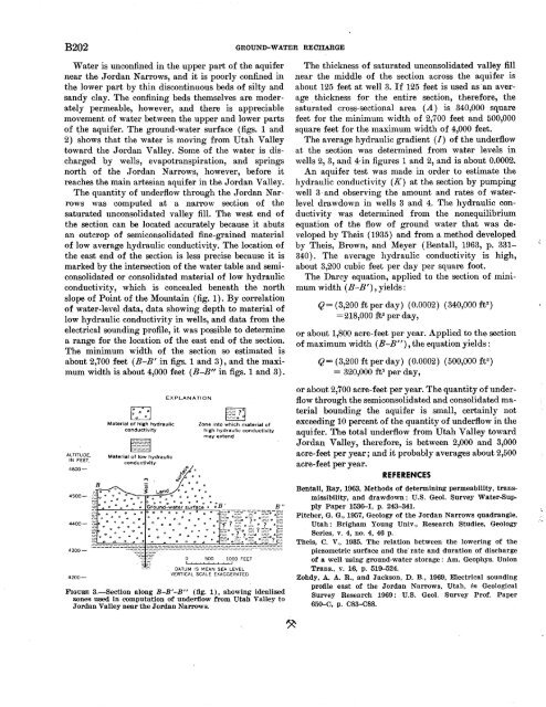
The quantity of underflow through the Jordan N arrows<br />
was computed at a narrow section of the<br />
saturated unconsolidated valley fill. The west end of<br />
the section can be located accurately because it abuts<br />
an outcrop of semiconsolidated fine-grained material<br />
of low average hydraulic conductivity. The location of<br />
the east end of the section is less precise because it is<br />
marked by the intersection of the water table and semiconsolidated<br />
or consolidated material of low hydraulic<br />
conductivity, which is concealed beneath the north<br />
slope of Point of the Mountain (fig. 1). By correlatio~<br />
of water-level data, data showing depth to material of<br />
low hydraulic conductivity in wells, and data from the<br />
electrical sounding profile, it was possible to determine<br />
a range for the location of the east end of the section.<br />
The minimum width of the section so estimated is<br />
about 2,700 feet (B-B' in figs. 1 and 3), and the maximum<br />
width is about 4,000 feet (B-B" in figs. 1 and 3).<br />
ALTITUDE,<br />
IN FEET.<br />
4600-<br />
4200-<br />
t><br />
D<br />
0<br />
Material of high hydraulic<br />
conductivity<br />
Material of low hydraulic<br />
conductivity·<br />
EXPLANATION<br />
Zone into which material of<br />
high hydraulic conductivity<br />
may extend<br />
0<br />
• • 0<br />
0 500 1000 FEET<br />
DATUM IS MEAN SEA LEVEL<br />
VERTICAL SCALE EXAGGERATED<br />
FIGURE 3.-Section along B-B '-B" (fig. 1), showing idealized<br />
zones used in computation of underflow from Utah Valley to<br />
Jordan Valley near the Jordan Narrows.<br />
The thickness of saturated unconsolidated valley fill<br />
near the middle of the section across the aquifer is<br />
about 125 feet at well 3. If 125 feet is used as·an average<br />
. thic~ness for the entire section, therefore, the<br />
saturated cross-sectional area (A) is 340,000 square<br />
feet for the minimum width of 2,700 feet and 500,000<br />
square feet for the maximum width of 4,000 feet.<br />
The average hydraulic gradient (/) of the underflow<br />
at the section was determined from water levels in<br />
wells 2, 3, and 4· in figures 1 and 2, and is about 0.0002.<br />
An aquifer test was made in order to estimate the<br />
hydraulic conductivity (K) at the section by pumping<br />
well 3 · and observing the amount and rates of waterlevel<br />
dra wdown in wells 3 and 4. The hydraulic conductivity<br />
was determined from the nonequilibrium<br />
equation of the flow of ground water that was developed<br />
by Theis ( 1935) and from a. method developed<br />
by Theis, Brown, and Meyer (Bentall, 1963, p. 331-<br />
340). The average hydraulic conductivity is high,<br />
about 3,200 cubic feet per day per square foot.<br />
The Darcy equation, applied to the section of minimum<br />
width (B-B'), yields:<br />
Q= (3,200 ft per day) (0.0002) (340,000 ft 2 )<br />
=218,000 ft 3 per day,<br />
or about 1,800 acre-feet per year. Applied to the section<br />
of maximum width ( B-B"), the equation yields:<br />
Q = ( 3,200 ft per day) ( 0.0002) ( 500,000 ft 2 )<br />
= 320,000 ft 3 per day,<br />
or about 2,700 acre-feet per year. The quantity of underflow<br />
through the semiconsolidated and consolidated material<br />
bounding the aquifer is small, certainly not<br />
exceeding 10 percent of the quantity of underflow in the<br />
aquifer. The total underflow from Utah Valley toward<br />
Jordan Valley, therefore, is between 2,000 and 3,000<br />
acre-feet per year; and it probably averages about 2,500<br />
acre-feet per year.<br />
REFERENCES<br />
Bentall, Ray, 1963, Methods of determining permeability, transmissibility,<br />
and drawdown: U.S. Geol. Survey Water-Supply<br />
Paper 1536--1, p. 243-341.<br />
Pitcher, G. G., 1957, Geology of the Jordan Narrows quadrangle,<br />
Utah: Brigham Young Univ., Research Studies, Geology<br />
Series, v. 4, no. 4, 46 p.<br />
Theis, C. V., 1935. The relation between the lowering of the<br />
piezometric surface and the· rate and duration of discharge<br />
of a well using ground-water storage : Am. Geophys. Union<br />
Trans., v. 16, p. 519-524.<br />
Zohdy, A. A. R., and Jackson, D. B., 1969, Electrical sounding<br />
profile east of the Jordan Narrows, Utah, in Geological<br />
Survey Research 1969: U.S. Geol. Survey Prof. Paper<br />
650-C, p. 083-088.


