- Page 1 and 2: . ., GEOLOGICAL SURVEY RESEARCH·
- Page 3 and 4: CONTENTS GEOLOGIC STUDIES Petrology
- Page 5 and 6: GEOLOGICAL SURVEY RESEARCH 1970 Geo
- Page 7 and 8: B2 PETROLOGY AND PETROGRAPHY for bi
- Page 9 and 10: B4 PETROLOGY AND PETROGRAPHY has be
- Page 11 and 12: B6 PETROLOGY AND PETROGRAPHY. 32
- Page 13 and 14: B8 PETROLOGY AND PETROGRAPHY TABLE
- Page 15 and 16: BlO · PETROLOGY AND PETROGRAPHY EX
- Page 17 and 18: B12 PETROLOGY AND PETROGRAPHY TABLE
- Page 19 and 20: GE,OLOGICAL SURVEY RESEA·RCH 1970
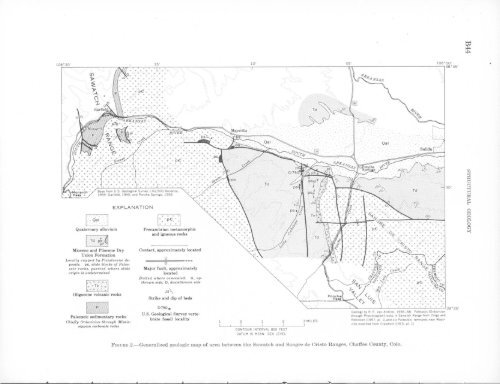
- Page 21 and 22: B16 PETROLOGY AND PETROGRAPHY Sprin
- Page 23 and 24: B18 PETROLOGY AND PETROGRAPHY TABLE
- Page 25 and 26: B20 PETROLOGY AND PETROGRAPHY Sigva
- Page 27 and 28: B22 PETROLOGY AND PETROGRAPHY EXPLA
- Page 29 and 30: B24 PE~ROLOGY AND PETROGRAPHY schis
- Page 31 and 32: B26 PETROLOGY AND PETROGRAPHY TABLE
- Page 33 and 34: B28 PETROLOGY AND PETROGRAPHY sg•
- Page 35 and 36: B30 PETROLOGY AND PETROGRAPHY Detri
- Page 37 and 38: B32 PETROLOGY AND PETROGRAPHY place
- Page 39 and 40: B34 PETROLOGY AND PETROGRAPHY 66 '
- Page 41 and 42: B36 PETROLOGY AND PETROGRAPHY Post-
- Page 43 and 44: B38 PETROLOGY AND PETROGRAPHY TABLE
- Page 45 and 46: B40 PETROLOGY AND PETROGRAPHY did n
- Page 47: B42 PETROLOGY AND PETROGRAPHY Creta
- Page 51 and 52: B46 STRUCTURAL GEOLOGY FIGURE 4.-Vi
- Page 53 and 54: B48 STRUCTURAL GEOLOGY FIGURE 6.-An
- Page 55 and 56: B50 STRUCTURAL GEOLOGY clined slide
- Page 57 and 58: GE,OLOGICAL SURVEY RESEARCH 1970 CA
- Page 59 and 60: B54 GEOPHYSICS (1950), Domzalski (1
- Page 61 and 62: B56 GEOPHYSICS STRATIGRAPHY AND LIT
- Page 63 and 64: B58 GEOPHYSICS STRATIGRAPHY AND LIT
- Page 65 and 66: B60 GEOPHYSICS value. A normal free
- Page 67 and 68: B62 GEOPHYSICS Hammer, Sigmund, 193
- Page 69 and 70: B64 110°45' GEOPHYSICS L I I \ "'\
- Page 71 and 72: GE·OLOGICAL SURVEY RESEA·RCH 1970
- Page 73 and 74: B68 GEOPHYSICS A' San 0 p A c I F I
- Page 75 and 76: B70 GEOPHYSICS lies occur over rela
- Page 77 and 78: B72 GEOPHYSICS 36° 00' A' 40___./
- Page 79 and 80: B74 GEOPHYSICS igneous massif is co
- Page 81 and 82: B76 GEOPHYSICS A 50 Bouguer gravity
- Page 83 and 84: GE·OLOGICAL SURVEY RESEARCH 1970 R
- Page 85 and 86: B80 GEOPHYSICS FIGURE 1.-Bouguell'
- Page 87 and 88: B82 GEOPHYSICS J I 37·~~------~~--
- Page 89 and 90: B84 GEOPHYSICS B 600 B' 500 400 (/)
- Page 91 and 92: GE,OLOGICAL SURVEY RESEA·RCH 1970
- Page 93 and 94: EXPLANATION Pikes Peak • batholit
- Page 95 and 96: DISTRIBUTION OF URANIUM IN URANIUM-
- Page 97 and 98: B92 GEOCHRONOLOGY Fleischer, R. L.,
- Page 99 and 100:
B94 ECONOMIC GEOLOGY 103° 35' w 1/
- Page 101 and 102:
'B96 ECONOMIC ·GEOLOGY 0 500 FEET
- Page 103 and 104:
B98 ECONOMIC GEOLOGY TABLE !.-Summa
- Page 105 and 106:
BlOO ECONOMIC GEOLOGY surface seems
- Page 107 and 108:
GE 1 0LOGICAL SURVEY RESEA·RCH 197
- Page 109 and 110:
B104 EJrucJh of the four samples wa
- Page 111 and 112:
B106 ECONOMIC GEOLOGY R. 56 E. R. 5
- Page 113 and 114:
B108 ECONOMIC GEOLOGY outcrop under
- Page 115 and 116:
BllO Brady, of the Museum of Northe
- Page 117 and 118:
Bll2 PALEONTOLOGY FIGURE 1.-ProtobZ
- Page 119 and 120:
B114 PALEONTOLOGY c .,;# I I ' ' lO
- Page 121 and 122:
B116 PALEONTOLOGY ments, the larges
- Page 123 and 124:
GErOLOGICAL SURVEY RESEA·RCH 1970
- Page 125 and 126:
B120 L xMH 'xE soo~~B_R~I __ T_I __
- Page 127 and 128:
B122 PALEONTOLOGY Tetrataxis sp. Te
- Page 129 and 130:
GE~OLOGICAL SURVEY RESEARCH 1970 TR
- Page 131 and 132:
Bl26 PALEONTOLOGY TABLE 2.-Ranges o
- Page 133 and 134:
B128 PALEONTOLOGY l
- Page 135 and 136:
BI30 PALEONTOLOGY Ocmt/rrence.-P. m
- Page 137 and 138:
Bl32 PALEONTOLOGY proximately 5.7 m
- Page 139 and 140:
Bl34 PALEONTOLOGY a b c d e f g - D
- Page 141 and 142:
Bl36 PALEONTOLOGY --- 1963. The ori
- Page 143 and 144:
B138 PALEONTOLOGY core are m1ssmg,
- Page 145 and 146:
B140 PALEONTOLOGY death assemblage:
- Page 147 and 148:
Bl42 STRATIGRAPHY EXPLANATION l:.\.
- Page 149 and 150:
B144 STRATIGRAPHY ver. We do not in
- Page 151 and 152:
B146 STRATIGRAPHY age. A stratigrap
- Page 153 and 154:
B148 5 10 15 20 X X Plntygonus Pla.
- Page 155 and 156:
GE~OLOGICAL SURVEY RESEARCH 1970 CL
- Page 157 and 158:
B152 STRATIGRAPHY at a depth of 58
- Page 159 and 160:
••••• 0 .... ••••
- Page 161 and 162:
B156 STRATIGRAPHY REFERENCES Brown,
- Page 163 and 164:
B158 STRATIGRAPHY In what follows,
- Page 165 and 166:
Bi60 STRATIGRAPHY TABLE !.-Stratigr
- Page 167 and 168:
B162 SEDIMENTATION with increasing
- Page 169 and 170:
llj ...... ~ TABLE 2.-Specific grav
- Page 171 and 172:
B166 TABLE 3.-Settling time for a 1
- Page 173 and 174:
Bl68 GEOMORPHOLOGY 74° 44° YERMON
- Page 175 and 176:
B170 GEOMORPHOLOGY have also been r
- Page 177 and 178:
B172 GEOMORPHOLOGY end of Long Isla
- Page 179 and 180:
GEOLOGICAL SURVEY RESEARCH 1970 DET
- Page 181 and 182:
~ooo ______________ B176 ANALYTICAL
- Page 183 and 184:
B178 terranes where the search for
- Page 185 and 186:
B180 Reproducibility Replicate anal
- Page 187 and 188:
B182 ANALYTICAL METHODS in the aque
- Page 189 and 190:
GEOLOGICAL SURVEY RESEARCH 1970 CHE
- Page 191 and 192:
B186 ANALYTICAL METHODS 3.31 percen
- Page 193 and 194:
Bl88 ANALYTICAL METHODS 3" 2%" Oute
- Page 195 and 196:
GEOLOGICAL SURVEY RESEA~RCH 1970 TR
- Page 197 and 198:
B192 GROUND-WATER RECHARGE I T I 14
- Page 199 and 200:
B194 GROUND-WATER RECHARGE Therefor
- Page 201 and 202:
GEOLOGICAL SURVEY RESEARCH 1970 PRE
- Page 203 and 204:
B198 GROUND-WATER RECHARGE the basi
- Page 205 and 206:
B200 GROUND-WATER RECHARGE t \ \)
- Page 207 and 208:
B202 GROUND-WATER RECHARGE Water is
- Page 209 and 210:
B204 GROUND-WATER CONTAMINATION rv
- Page 211 and 212:
B206 GROUND-WATER CONTAMINATION TAB
- Page 213 and 214:
B208. GROUND-WATER CONTAMINATION fa
- Page 215 and 216:
GEOLOGICAL SURVEY RESEARCH 1970 MEA
- Page 217 and 218:
B212 SURFACE WATER plotted, and the
- Page 219 and 220:
GEOLOGICAL SURVEY RESEA·RCH 1970 T
- Page 221 and 222:
B216 SURFACE WATER however, if the
- Page 223 and 224:
B218 SURFACE WATER TABLE 4.-Variati
- Page 225 and 226:
B220 RELATION· BETWEEN GROUND eral
- Page 227 and 228:
B222 -0.010 f -0.005 (i) RELATION B
- Page 229 and 230:
GEOLOGICAL SURVEY RESEARCH 1970 THE
- Page 231 and 232:
'B226 RELATION BETWEEN GROUND WATER
- Page 233 and 234:
B228 RELATION, BETWEEN GROUND WATER
- Page 235 and 236:
B230 RELATION BETWEEN GROUND WATER
- Page 237 and 238:
GEOLOGICAL SURVEY RESEARCH 1970 HYD
- Page 239 and 240:
B234 EROSION AND SEDIMENTATION side
- Page 241 and 242:
B236 EROSION AND SEDIMENTATION s·o
- Page 243 and 244:
B238 EROSION AND SEDIMENTATION Cont
- Page 245 and 246:
B240 EROSION AND SEDIMENTATION 2 3
- Page 247 and 248:
GEOLOGICAL SURVEY RESEARCH 1970 SPE
- Page 249 and 250:
B244 GEOCHEMISTRY OF WATER REFERENC
- Page 251 and 252:
B246 HYDROLOGIC TECHNIQUES The upla
- Page 253 and 254:
B248 HYDROLOGIC TECHNIQUES type in
- Page 255 and 256:
GEOLOGICAL SURVEY RESEARCH 1970 ,,.
- Page 257 and 258:
B252 formula may also be useful in
- Page 259 and 260:
GEO'LOGICAL SURVEY RESEARCH 1970 CO
- Page 261 and 262:
B256 randomly fluctuating component
- Page 263 and 264:
B258 HYDROLOGIC TECHNIQUES 1.0 ~ Qj
- Page 265 and 266:
~ B260 HYDROLOGIC TECHNIQUES 1-3, f
- Page 267 and 268:
I B262 HYDROLOGIC TECHNIQUES REFERE
- Page 269 and 270:
,' B264 Page Gravitational sliding,
- Page 271 and 272:
., / )